跳至內容

File:Tembin Aug 20 2012 0235Z (alternate).jpg

頁面內容不支援其他語言。
這個檔案來自維基共享資源
維基百科,自由的百科全書

原始檔案 (5,200 × 6,800 像素,檔案大小:8.61 MB,MIME 類型:image/jpeg


摘要

描述
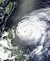
English: After four other Typhoons—Saola, Damrey, Haikui, and Kai-tak—made landfall in eastern China in just three weeks, Typhoon Tembin appeared ready to do the same. Tembin formed as a tropical depression over the western Pacific Ocean on August 19, 2012, and strengthened to a typhoon the next day.

The Moderate Resolution Imaging Spectroradiometer (MODIS) on NASA’s Terra satellite captured this natural-color image on August 20. Sporting a well-defined eye, Tembin hovered over the ocean just east of the Philippine island of Luzon. Although next to the Philippines, Tembin was not actually forecast to make landfall there. The U.S. Navy’s Joint Typhoon Warning Center (JTWC) forecast that Tembin would head northward before turning west and coming ashore in Taiwan and China. Focus Taiwan News Channel reported that Tembin might make landfall on Taiwan’s east coast on August 23.

The same day that MODIS took this picture, the JTWC reported that Tembin was a powerful storm. Located about 320 nautical miles (595 kilometers) northeast of Manila, Tembin had maximum sustained winds of 95 knots (175 kilometers per hour) and gusts up to 115 knots (215 kilometers per hour). Over the next 36 hours, Tembin was expected to strengthen, developing maximum sustained winds of 120 knots (220 kilometers per hour) and gusts up to 145 knots (270 kilometers per hour).
日期
來源 http://lance-modis.eosdis.nasa.gov/wms/?zoom=5&lat=-16.87793&lon=160.16895&layers=B0000FFFFT&datum1=08/20/2012
作者 LANCE MODIS Rapid Response Team at NASA.
授權許可
(重用此檔案)

Public Domain

Public domain 本作品由NASA創作,屬於公有領域。根據NASA的版權政策:“NASA的創作除非另有聲明否則不受版權保護。”(參見:Template:PD-USGov/zhNASA版權政策JPL圖像使用政策
警告:

說明

添加單行說明來描述出檔案所代表的內容

在此檔案描寫的項目

描繪內容

檔案歷史

點選日期/時間以檢視該時間的檔案版本。

日期/時間縮⁠圖尺寸使用者備⁠註
目前2012年10月29日 (一) 12:56於 2012年10月29日 (一) 12:56 版本的縮圖5,200 × 6,800(8.61 MB)Earth100Best Image
2012年8月20日 (一) 05:21於 2012年8月20日 (一) 05:21 版本的縮圖5,604 × 6,729(10.04 MB)Earth100

全域檔案使用狀況

以下其他 wiki 使用了這個檔案:

詮釋資料