
File:California US Congressional District 25 (since 2013).tif

此 TIF 檔案的 PNG 預覽的大小:800 × 396 像素。 其他解析度:320 × 158 像素 | 640 × 317 像素 | 1,024 × 507 像素 | 2,016 × 998 像素。
原始檔案 (2,016 × 998 像素,檔案大小:2.69 MB,MIME 類型:image/tiff)
摘要
| 描述 |
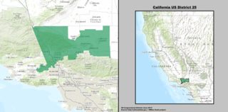
English: Map of the 25th Congressional District, representing part of northern Los Angeles County and part of eastern Ventura County, in Southern California.
Español: Mapa del 25.º Distrito Congresional de California— en Condados de Los Angeles y Ventura. |
| 日期 | |
| 來源 | GIS shapefile data created by the United States Department of the Interior, as part of the "1 Million Scale" geospatial data project. Retrieved from: http://nationalatlas.gov/atlasftp-1m.html?openChapters=#chpbound |
| 作者 | 1: GIS (congressional districts, 2013) shapefile data was created by the United States Department of the Interior. 2: Data was rendered using ArcGIS® software by Esri. 3: File developed for use on Wikipedia and elsewhere by 7partparadigm. |
授權條款
本地圖取自美國國家地圖集的某個版本。國家地圖集的絕大多數作品是美國聯邦政府的作品,因此屬於公有領域。
連結網址︰ NationalAtlas.gov | 1970年印刷版︰ 國會檔案館, Perry-Castañeda圖書館
|
en:California's 25th congressional district es:25.º distrito congresional de California
檔案歷史
點選日期/時間以檢視該時間的檔案版本。
| 日期/時間 | 縮圖 | 尺寸 | 用戶 | 備註 | |
|---|---|---|---|---|---|
| 目前 | 2014年3月22日 (六) 03:18 |  | 2,016 × 998(2.69 MB) | 7partparadigm | User created page with UploadWizard |
檔案用途
下列頁面有用到此檔案:
全域檔案使用狀況
以下其他 wiki 使用了這個檔案:
- en.wikipedia.org 的使用狀況
- fr.wikipedia.org 的使用狀況
- hu.wikipedia.org 的使用狀況
- tr.wikipedia.org 的使用狀況
- www.wikidata.org 的使用狀況