
File:French Hercynian massifs EN.svg

此 SVG 檔案的 PNG 預覽的大小:800 × 555 像素。 其他解析度:320 × 222 像素 | 640 × 444 像素 | 1,024 × 711 像素 | 1,280 × 888 像素 | 2,560 × 1,777 像素 | 850 × 590 像素。
原始檔案 (SVG 檔案,表面大小:850 × 590 像素,檔案大小:274 KB)
摘要
| 描述 |
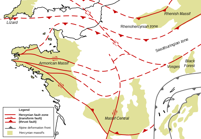
English: Structural geologic map of the north of France, showing Hercynian massifs and structures. Based on figures and information in the following literature:
|
| 日期 | |
| 來源 | 自己的作品 |
| 作者 | Woudloper |
| 其他版本 |
 |
授權條款
| 我,此作品的版權所有人,釋出此作品至公共領域。此授權條款在全世界均適用。 這可能在某些國家不合法,如果是的話: 我授予任何人有權利使用此作品於任何用途,除受法律約束外,不受任何限制。 |
檔案歷史
點選日期/時間以檢視該時間的檔案版本。
| 日期/時間 | 縮圖 | 尺寸 | 用戶 | 備註 | |
|---|---|---|---|---|---|
| 目前 | 2008年11月27日 (四) 21:37 | | 850 × 590(274 KB) | Woudloper | {{Information |Description={{en|1=Structural geologic map of the north of France, showing Hercynian massifs and structures. Based on figures and information in the following literature: *{{aut|Service Géologique National}}; '''1996''': ''Carte géologiqu |
檔案用途
下列頁面有用到此檔案:
全域檔案使用狀況
以下其他 wiki 使用了這個檔案:
- en.wikipedia.org 的使用狀況
- ja.wikipedia.org 的使用狀況
- ro.wikipedia.org 的使用狀況
- uk.wikipedia.org 的使用狀況