
File:GlenHelenGorge NorthernTerritory Panorama.jpg

原始檔案 (10,609 × 2,340 像素,檔案大小:17.6 MB,MIME 類型:image/jpeg)
|

This image was selected as picture of the day on Wikimedia Commons for 1 July 2010. It was captioned as follows: English: Today is "Territory Day" in the Northern Territory of Australia, and marks the commencement of self-government in the Territory on 1st July 1978. This photograph is of the western wall of the Glen Helen Gorge, part of the West MacDonnell Ranges in the Northern Territory. These ranges were formed when the Alice Springs Orogeny pushed a 12km thick slab of rock vertical, running roughly east-west for 644km. Other languages:
Afrikaans: Vandag is dit "Territory Day" (d.w.s. "Territoriumdag") in die Australiese Noordelike Territorium, 'n dag wat geskiedkundig beskou word as die dag waarop die territorium selfbestuur verkry het, naamlik 1 Julie 1978. Die foto toon die westelike rand van die Glen Helen Kloof in die MacDonnellgebergte. Die gebergte bestaan uit 'n aantal ewewydig gerangskikte bergkettings in die territorium. Dit is gevorm toe die Alice Springs orogenese ('n bergvorming vernoem na die gelyknamige dorp) oor 'n lengte van 644km 'n laag rots van 12km dikte, rofweg van oos na wes, vertikaal omhoog gedruk het. Čeština: Západní stěna Glen Helen Gorge, části pohoří MacDonnell Ranges v australském Severním teritoriu; dnes se v Severním teritoriu slaví výročí získání autonomie 1. července 1978 Dansk: I dag er det "Territory Day" i Northern Territory i Australien til minde om indførelsen af selvstyre for territoriet 1. juli 1978. Dette foto viser vestsiden af Glen Helen Gorge, der er en del af MacDonnell Ranges i Northern Territory. Deutsch: Heute ist "Territory Day" in den australischen Northern Territory. Das Datum markiert den Beginn der Selbstverwaltung dieses Territoriums am 1. Juli 1978. Dieses Foto zeigt die Westwand der Glen Helen Gorge, ein Teil der West MacDonnell Ranges. Diese Gebirgszüge wurden gebildet, als sich während der Orogenese von Alice Springs eine 12km dicke Felsplatte vertikal verschob. Sie verläuft etwa 644km in Ost/West-Richtung. English: Today is "Territory Day" in the Northern Territory of Australia, and marks the commencement of self-government in the Territory on 1st July 1978. This photograph is of the western wall of the Glen Helen Gorge, part of the West MacDonnell Ranges in the Northern Territory. These ranges were formed when the Alice Springs Orogeny pushed a 12km thick slab of rock vertical, running roughly east-west for 644km. Español: La pared occidental del Glen Helen Gorge, en la cadena montañosa de 640 km de longitud del West MacDonnell Ranges en el Territorio del Norte, Australia. Esta fracturada montaña se formó durante la orogenésis de Alice Springs, un evento tectónico ocurrido hace entre 450 y 300 millones de años en Australia Central. Hoy es el Territory Day (‘día del territorio’) en el Territorio del Norte, el aniversario de la institución del gobierno federal (1 de julio de 1978). Italiano: La parete occidentale del Glen Helen Gorge, nella catena montuosa (640 km di lunghezza) dei West MacDonnell Ranges nel Territorio del Nord, in Australia. Queste frastagliate montagne si sono formate durante l'orogenesi di Alice Springs, un evento tettonico intercorso tra i 450 e i 300 Ma fa nell'Australia Centrale. Oggi è il “Territory Day” («giorno del territorio») nel Territorio del Nord, l'anniversario dell'istituzione del governo federale (1º luglio 1978). Magyar: A mai nap az ausztráliai Northern Territoryban a Territory Day ünnepe, a Territory önkormányzatának 1978. július 1-jei születésére emlékezik. A fotón a Glen Helen Gorge nyugati fala látható Nederlands: Vandaag is het "Territory Day" ("Territoriumdag") in het Australische Noordelijk Territorium, historisch gezien de dag waarop het territorium zelfbestuur verkreeg op 1 juli 1978. De foto toont de westelijke rand van de Glen Helen Gorge, een kloof in het MacDonnellgebergte. Dit gebergte bestaat uit een aantal evenwijdig aan elkaar gelegen bergketens in het territorium die werden gevormd toen de Orogenese van Alice Springs (naar het gelijknamige stadje) over een lengte van 644 kilometer een 12 kilometer dikke laag rots verticaal omhoog drukte, grofweg in oost-westelijke richting. Norsk bokmål: I dag er det «Territory Day» i Nordterritoriet i Australia til minne om innførselen av selvstyre for territoriet 1. juli 1978. Dette bildet viser vestsiden av Glen Helen Gorge, som er en del av MacDonnell Ranges i Nordterritoriet. Македонски: Западниот бедем на клисурата Глен Хелен на планинскиот венец Вест Макдонел во Северната Територија, Австралија. বাংলা : আজ অস্ট্রেলিয়ার নর্দার্ন টেরিটতে আজকে ‘টেরিটরি দিবস’। এই দিনে এখানে ১৯৭৮ সালের ১ জুলাই পাওয়া স্বায়ত্বশাসন উদযাপন করা হয়। এই আলোকচিত্রে গ্লেন হেলেন জর্জের পশ্চিম দিকের দেওয়ালটি ফুটিয়ে তোলা হয়েছে। এটি নর্দার্ন টেরিটরির পশ্চিম ম্যাকডানেল রেঞ্জের অংশ। 日本語: 今日7月1日はノーザンテリトリー(オーストラリア)の「テリトリー・デー」。ノーザンテリトリーは準州として1978年7月1日に自治権を獲得した。写真は同テリトリーに位置する西マクドネル山脈の一部をなすグレン・ヘレン峡谷の西壁。マクドネル山脈はアリススプリングス造山運動の際、概ね東西方向644kmにわたる厚さ12kmの岩盤が押されることで形成されたものである。 中文: 澳大利亚北领地麦克唐奈尔山脉格兰海伦峡谷风景。这些山脉因艾丽丝泉造山运动形成12公里厚的垂直岩石板,延绵644公里。 中文(繁體): 澳洲北領地麥克唐奈爾山脈格蘭海倫峽谷風景。這些山脈因艾麗絲泉造山運動形成12公里厚的垂直岩石板,延綿644公里。 |
摘要
| 描述 |
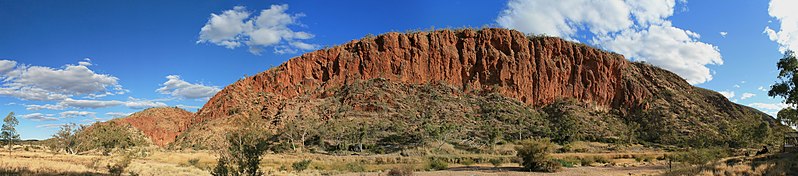
English: A panoramic view of the western wall of the Glen Helen Gorge in the late afternoon. The Gorge itself can be seen in between peaks on the left. The Finke river, with its mostly dry river bed and glimpses of water, can be seen in the foreground. The trees along the river bed are primarily River Red Gums. The cloud cover is the start of an infrequent dry season cold front which brought rains to the region.
This geological formation is part of the West MacDonnell Ranges in Australia's Northern Territory. The layers once lay horizontal at the bottom of the Amadeus basin. The Alice Springs orogeny pushed a 12km thick slab vertical, running roughly east-west for 644km. This gorge is primarily formed of red quartzite, which withstood subsequent erosion better than the softer layers around it. The entire Ranges have been classified as National Park. Français : Vue panoramique du bord ouest de la gorge Glen Helen en fin d'après-midi. La gorge elle même est visible entre les sommets sur la gauche de l'image. Le lit de la rivière Finke, avec un peu d'eau, est au premier plan. Les arbres qui la bordent sont principalement des Gommiers rouges. Les nuages annoncent un front froid porteur de pluie, un évènement peu fréquent durant la saison sèche. Cette formation géologique fait partie de la chaine des West MacDonnell dans le Territoire du Nord australien. L'orogénie d'Alice Springs a redressé une dalle de 12 km de quartzites rouges sur une longueur de 644 km. La gorge a été creusée dans cette dalle, qui a mieux supporté l'érosion que les roches plus tendres qui l'entouraient au moment de l'orogénie. La chaine est totalement incluse dans un parc national. |
| 日期 | |
| 來源 | 自己的作品 |
| 作者 | Toby Hudson |
| 其他版本 |
 |
_WV_banner.jpg)
| 拍攝地點 | | 位於此地的本圖片與其他圖片: OpenStreetMap |
|---|
授權條款
- 您可以自由:
- 分享 – 複製、發佈和傳播本作品
- 重新修改 – 創作演繹作品
- 惟需遵照下列條件:
- 姓名標示 – 您必須指名出正確的製作者,和提供授權條款的連結,以及表示是否有對內容上做出變更。您可以用任何合理的方式來行動,但不得以任何方式表明授權條款是對您許可或是由您所使用。
- 相同方式分享 – 如果您利用本素材進行再混合、轉換或創作,您必須基於如同原先的相同或兼容的條款,來分布您的貢獻成品。

|
已授權您依據自由軟體基金會發行的無固定段落、封面文字和封底文字GNU自由文件授權條款1.2版或任意後續版本,對本檔進行複製、傳播和/或修改。該協議的副本列在GNU自由文件授權條款中。 |
| 註解 | 該圖片含有註解:在維基媒體共享資源上查看註解 |
檔案歷史
點選日期/時間以檢視該時間的檔案版本。
| 日期/時間 | 縮圖 | 尺寸 | 用戶 | 備註 | |
|---|---|---|---|---|---|
| 目前 | 2009年10月29日 (四) 21:24 | 10,609 × 2,340(17.6 MB) | Sting | Same image but with sRGB color profile embedded | |
| 2009年10月23日 (五) 14:04 | 10,609 × 2,340(17.29 MB) | 99of9 | Resaved with EXIF data embedded and cloned dark regions of upper left sky (per User:Sting, thanks again!) | ||
| 2009年10月23日 (五) 07:00 | 10,609 × 2,340(17.37 MB) | 99of9 | {{Information |Description={{en|1=A panoramic view of the western wall of the Glen Helen Gorge in the late afternoon. The Gorge itself can be seen in between peaks on the left. The Finke river, with its mostly dry river bed, and glimpses of water can be |
檔案用途
下列3個頁面有用到此檔案:
全域檔案使用狀況
以下其他 wiki 使用了這個檔案:
- bn.wikipedia.org 的使用狀況
- ca.wikipedia.org 的使用狀況
- ceb.wikipedia.org 的使用狀況
- crh.wikipedia.org 的使用狀況
- cv.wikipedia.org 的使用狀況
- en.wikipedia.org 的使用狀況
- en.wikivoyage.org 的使用狀況
- es.wikipedia.org 的使用狀況
- eu.wikipedia.org 的使用狀況
- hu.wikipedia.org 的使用狀況
- it.wikivoyage.org 的使用狀況
- ko.wikipedia.org 的使用狀況
- krc.wikipedia.org 的使用狀況
- lbe.wikipedia.org 的使用狀況
- mg.wikipedia.org 的使用狀況
- mk.wikipedia.org 的使用狀況
- ml.wikipedia.org 的使用狀況
- os.wikipedia.org 的使用狀況
- pl.wikipedia.org 的使用狀況
- pt.wikipedia.org 的使用狀況
- ru.wikipedia.org 的使用狀況
- ru.wikinews.org 的使用狀況
- sah.wikipedia.org 的使用狀況
- uk.wikipedia.org 的使用狀況
- vi.wikipedia.org 的使用狀況
- www.wikidata.org 的使用狀況
- xal.wikipedia.org 的使用狀況