
File:Great Lakes from space.jpg

預覽大小:800 × 485 像素。 其他解析度:320 × 194 像素 | 640 × 388 像素 | 900 × 546 像素。
原始檔案 (900 × 546 像素,檔案大小:147 KB,MIME 類型:image/jpeg)
摘要
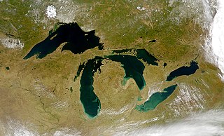
| 描述 | Satellite image of the Great Lakes from space |
| 日期 | |
| 來源 | http://visibleearth.nasa.gov/view_rec.php?id=793 |
| 作者 | SeaWiFS Project, NASA/Goddard Space Flight Center, and ORBIMAGE. |
| 其他版本 |
  |
授權條款
| This image is from the Sea-viewing Wide Field-of-view Sensor (SeaWiFS) Project and more than 5 years old.
Satellite data captured by the SeaWIFS sensor are released into the public domain 5 years after capture. Data less than five years old can be re-used only for educational or scientific purposes; any commercial use of such images must be coordinated with GeoEye. [1] |
| This work has been released into the public domain by its copyright holder, GeoEye. This applies worldwide. 這可能在某些國家不合法,如果是的話: GeoEye授予任何人有權利使用此作品於任何用途,除受法律約束外,不受任何限制。
|
檔案歷史
點選日期/時間以檢視該時間的檔案版本。
| 日期/時間 | 縮圖 | 尺寸 | 用戶 | 備註 | |
|---|---|---|---|---|---|
| 目前 | 2010年9月22日 (三) 15:22 | | 900 × 546(147 KB) | Floydian | Reverted to version as of 03:45, 19 March 2005. Upload under a new filename, some pages depend on the former image showing the surroundings of the lakes (eg. Lake Nipigon) |
| 2010年9月6日 (一) 16:02 |  | 5,200 × 4,000(3.77 MB) | Anirudh Emani | High Resolution + Improved Image Quality | |
| 2005年3月19日 (六) 03:45 |  | 900 × 546(147 KB) | Fanghong | from en wiki |
檔案用途
下列35個頁面有用到此檔案:
全域檔案使用狀況
以下其他 wiki 使用了這個檔案:
- af.wikipedia.org 的使用狀況
- als.wikipedia.org 的使用狀況
- an.wikipedia.org 的使用狀況
- arc.wikipedia.org 的使用狀況
- ar.wikipedia.org 的使用狀況
- arz.wikipedia.org 的使用狀況
- be-tarask.wikipedia.org 的使用狀況
- bg.wikipedia.org 的使用狀況
- br.wikipedia.org 的使用狀況
- ca.wikipedia.org 的使用狀況
- co.wikipedia.org 的使用狀況
- cs.wikipedia.org 的使用狀況
- da.wikipedia.org 的使用狀況
- de.wikipedia.org 的使用狀況
- en.wikipedia.org 的使用狀況
- en.wikibooks.org 的使用狀況
- eo.wikipedia.org 的使用狀況
- es.wikipedia.org 的使用狀況
- et.wikipedia.org 的使用狀況
- eu.wikipedia.org 的使用狀況
- fa.wikipedia.org 的使用狀況
檢視此檔案的更多全域使用狀況。