跳至內容

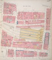
File:Insurance Plan of City of London Vol. I; sheet 23 (BL 150118).tiff

頁面內容不支援其他語言。
這個檔案來自維基共享資源
維基百科,自由的百科全書

原始檔案 (3,159 × 3,693 像素,檔案大小:33.38 MB,MIME 類型:image/tiff


摘要

標題
Insurance Plan of City of London Vol. I: sheet 23
描寫文
English: This detailed 1886 plan of London is one of a series of twenty-five sheets in an atlas originally produced to aid insurance companies in assessing fire risks. The building footprints, their use (commercial, residential, educational, etc.), the number of floors and the height of the building, as well as construction materials (and thus risk of burning) and special fire hazards (chemicals, kilns, ovens) were documented in order to estimate premiums. Names of individual businesses, property lines, and addresses were also often recorded. Together these maps provide a rich historical shapshot of the commercial activity and urban landscape of towns and cities at the time. The British Library holds a comprehensive collection of fire insurance plans produced by the London-based firm Charles E. Goad Ltd. dating back to 1885. These plans were made for most important towns and cities of the British Isles at the scales of 1:480 (1 inch to 40 feet), as well as many foreign towns at 1:600 (1 inch to 50 feet).
日期
來源
Catalogue: http://www.bl.uk/onlinegallery/onlineex/firemaps/england/london/itov/mapsu145ubu22u1uf023r.html
Viewer: http://www.bl.uk/onlinegallery/onlineex/firemaps/england/london/itov/zoomify150118.html
創作作者
Chas E Goad Limited
 Geotemporal data
描繪日期
地圖位置 London and South East
比例尺 Inches [1:480]. 40 ft = 1 inch. and [1:2400]. 200 ft = 1 inch.
地理參考 地理參考Wikimaps Warper中的地圖 如果不合適,請設定「warp_status = skip」為隱藏。
 Bibliographic data
出版商
Chas E Goad Limited
 Archival data
The British Library
登錄號
Maps 145.b.22.(.1)
表現方法 Image
備註 Content-id: 150118


授權條款

Public domain

本作品在其來源國以及其他版權期限是作者逝世後100年或以下的國家與地區屬於公有領域


這個作品在美利堅合眾國屬於公有領域,因為它首次發布早於1929年1月1日,或於該日期之前在美國著作權局登記。

此作品無已知的著作權限制,亦不受所有相關和鄰接的權利限制。

說明

添加單行說明來描述出檔案所代表的內容

在此檔案描寫的項目

描繪內容

沼澤門站 中文 (已轉換拼寫)

檔案歷史

點選日期/時間以檢視該時間的檔案版本。

日期/時間縮⁠圖尺寸用戶備⁠註
目前2017年3月24日 (五) 18:39於 2017年3月24日 (五) 18:39 版本的縮圖3,159 × 3,693(33.38 MB)British Library Fire insurance maps, #313, http://www.bl.uk/onlinegallery/onlineex/firemaps/england/london/itov/mapsu145ubu22u1uf023r.html

下列頁面有用到此檔案:

全域檔案使用狀況

以下其他 wiki 使用了這個檔案:

詮釋資料