
File:NYCS map 1.svg

此 SVG 檔案的 PNG 預覽的大小:490 × 599 像素。 其他解析度:196 × 240 像素 | 393 × 480 像素 | 628 × 768 像素 | 838 × 1,024 像素 | 1,676 × 2,048 像素 | 648 × 792 像素。
原始檔案 (SVG 檔案,表面大小:648 × 792 像素,檔案大小:464 KB)
摘要
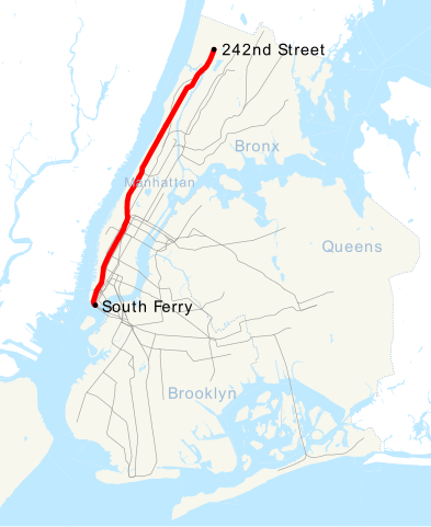
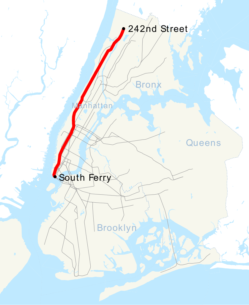
| 描述 | This is a map showing the New York City Subway's 1 service. It was created with TIGER/Line GIS data (water and boundaries) and my own data (subway lines and stations, traced on TIGER/Line road data). If you would like a copy of the subway data, email me. |
| 日期 | 2007年四月30日 (原始上傳日期) |
| 來源 | 无法识别来源。根据版权声明推断为其自己的作品。 |
| 作者 | 无法识别作者。根据版权声明推断作者为NE2。 |
授權條款
| 我,此作品的版權所有人,釋出此作品至公共領域。此授權條款在全世界均適用。 這可能在某些國家不合法,如果是的話: 我授予任何人有權利使用此作品於任何用途,除受法律約束外,不受任何限制。 |
檔案歷史
點選日期/時間以檢視該時間的檔案版本。
| 日期/時間 | 縮圖 | 尺寸 | 用戶 | 備註 | |
|---|---|---|---|---|---|
| 目前 | 2016年3月18日 (五) 21:45 | | 648 × 792(464 KB) | PrecipiceofDuck | Map updated to include 7 line extension. |
| 2011年10月29日 (六) 11:01 |  | 648 × 792(462 KB) | Robot8A | text to path because you can't see it properly on article | |
| 2008年6月27日 (五) 17:51 |  | 648 × 792(389 KB) | Imdanumber1~commonswiki | Reverted to version as of 23:33, 30 April 2007; what the heck happened? | |
| 2008年6月27日 (五) 17:50 |  | 648 × 792(416 KB) | Imdanumber1~commonswiki | == Summary == This is a map showing the New York City Subway's 1 service. It was created with TIGER/Line GIS data (water and boundaries) and my own data (subway lines and stations, traced on TIGER/Line road data). If you would like a copy of the subway da | |
| 2007年4月30日 (一) 23:33 |  | 648 × 792(389 KB) | NE2 | == Summary == This is a map showing the New York City Subway's 1 service. It was created with TIGER/Line GIS data (water and boundaries) and my own data (subway lines and stations, traced on TIGER/Line road data). If you would like a copy of the subway da |
檔案用途
下列頁面有用到此檔案:
全域檔案使用狀況
以下其他 wiki 使用了這個檔案:
- az.wikipedia.org 的使用狀況
- be.wikipedia.org 的使用狀況
- ca.wikipedia.org 的使用狀況
- de.wikipedia.org 的使用狀況
- en.wikipedia.org 的使用狀況
- es.wikipedia.org 的使用狀況
- fi.wikipedia.org 的使用狀況
- fr.wikipedia.org 的使用狀況
- he.wikipedia.org 的使用狀況
- id.wikipedia.org 的使用狀況
- ja.wikipedia.org 的使用狀況
- ko.wikipedia.org 的使用狀況
- lmo.wikipedia.org 的使用狀況
- nl.wikipedia.org 的使用狀況
- no.wikipedia.org 的使用狀況
- pl.wikipedia.org 的使用狀況
- pt.wikipedia.org 的使用狀況
- ru.wikipedia.org 的使用狀況
- tr.wikipedia.org 的使用狀況
- www.wikidata.org 的使用狀況