
File:Thermopylae shoreline changes map.png
此為最大尺寸。
Thermopylae_shoreline_changes_map.png (542 × 417 像素,檔案大小:88 KB,MIME 類型:image/png)
摘要
| 描述 |
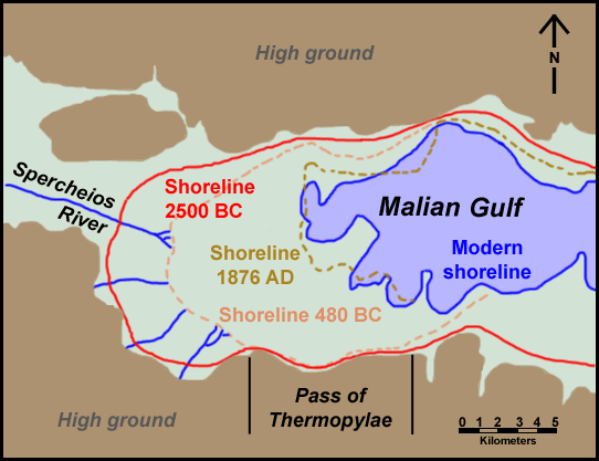
English: Map of Thermopylae area with modern shoreline and reconstructed shorelines of 1872 AD, 480 BC and 2500 BC. Loosely based on figure 3.19 in Geoarchaeology: The Earth-science Approach to Archaeological Interpretation, p. 96. George Robert Rapp, Christopher L. Hill. Yale University Press, 2006. ISBN 0300109660 |
| 日期 | |
| 來源 | 自己的作品 |
| 作者 | ChrisO |
| 授權許可 (重用此檔案) |
Public domain |
授權條款
| 我,此作品的版權所有人,釋出此作品至公共領域。此授權條款在全世界均適用。 這可能在某些國家不合法,如果是的話: 我授予任何人有權利使用此作品於任何用途,除受法律約束外,不受任何限制。 |
檔案歷史
點選日期/時間以檢視該時間的檔案版本。
| 日期/時間 | 縮圖 | 尺寸 | 用戶 | 備註 | |
|---|---|---|---|---|---|
| 目前 | 2011年6月12日 (日) 08:27 | | 542 × 417(88 KB) | Cplakidas | minor corrections on names |
| 2008年10月1日 (三) 00:00 |  | 542 × 417(31 KB) | ChrisO | {{Information |Description={{en|1=Map of Thermopylae area with modern shoreline and reconstructed shorelines of 1872 AD, 480 BC and 2500 BC. Loosely based on figure 3.19 in ''Geoarchaeology: The Earth-science Approach to Archaeological Interpretation'', p |
檔案用途
下列頁面有用到此檔案:
全域檔案使用狀況
以下其他 wiki 使用了這個檔案:
- ar.wikipedia.org 的使用狀況
- azb.wikipedia.org 的使用狀況
- br.wikipedia.org 的使用狀況
- ca.wikipedia.org 的使用狀況
- da.wikipedia.org 的使用狀況
- de.wikipedia.org 的使用狀況
- el.wikipedia.org 的使用狀況
- en.wikipedia.org 的使用狀況
- fi.wikipedia.org 的使用狀況
- fr.wikipedia.org 的使用狀況
- hr.wikipedia.org 的使用狀況
- hu.wikipedia.org 的使用狀況
- id.wikipedia.org 的使用狀況
- la.wikipedia.org 的使用狀況
- mk.wikipedia.org 的使用狀況
- ru.wikipedia.org 的使用狀況
- sh.wikipedia.org 的使用狀況
- simple.wikipedia.org 的使用狀況
- sr.wikipedia.org 的使用狀況
- tr.wikipedia.org 的使用狀況
- uk.wikipedia.org 的使用狀況
- vi.wikipedia.org 的使用狀況