
File:BritishEmpire1919.png
預覽大小:800 × 409 像素。 其他解析度:320 × 163 像素 | 640 × 327 像素 | 1,425 × 728 像素。
原始檔案 (1,425 × 728 像素,檔案大小:52 KB,MIME 類型:image/png)

|
本圖片是以PNG、GIF或JPEG格式上傳。然而,其中包含的資料或訊息,應該重新建立成可縮放向量圖形(SVG)檔案,以更有效率或更準確的方式儲存。如有可能,請上傳本圖片的SVG格式版本。在上傳之後,請修改維基各姊妹計畫中所有使用舊版圖片的條目(列在圖像連結章節中),替換為新版圖片,並在舊圖片的描述頁中加入{{Vector version available|新圖片名稱.svg}}模板,同時移除本模板。
|
摘要
| 描述 |
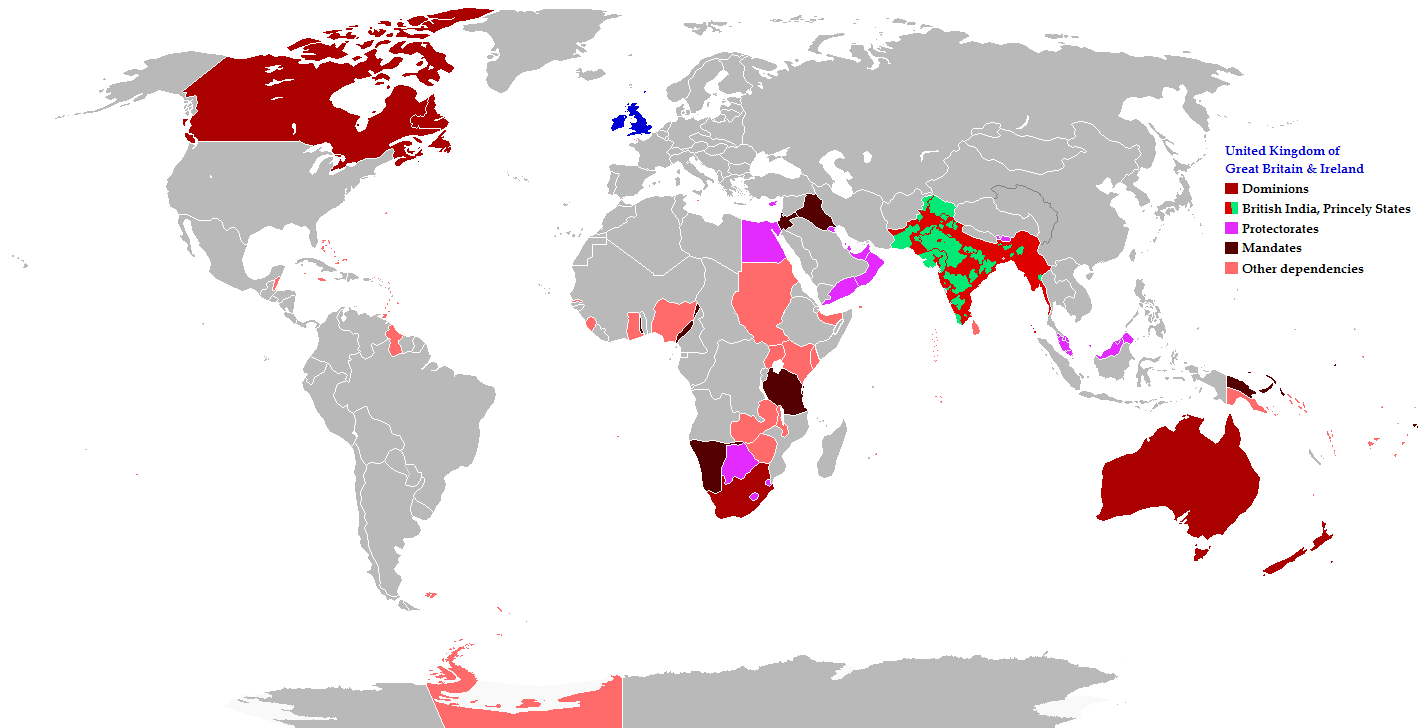
English: Map of the British Empire in 1919 showing all the territories, including the dominions, colonies, protectorates and mandates, ruled or administered by the United Kingdom and its successor states during that year.
Français : Carte de l'Empire britannique en 1919 illustrant tous les territoires, tels que les dominions, colonies, protectorats et mandats, gouvernés ou administrés par le Royaume-Uni ou ses États successeurs cette année-là.
Español: Un mapa de todas las afirmaciones oficiales territorial del Imperio Británico que se celebró en 1919 que identifica qué tipo de celebración estaba presente en todas las posesiones durante ese año.
Deutsch: Eine Karte aller offiziellen territorialen Ansprüche des Britischen Empire, die es im Jahre 1919 hatte, nach Art der Besitzungen in diesem Jahr.
فارسی: نقشه بیمورد از همه ادعاهای ارضی رسمی امپراطوری بریتانیا که در سال 1919 که برای شناسایی نوع برگزاری در حال حاضر تمام اموال در آن سال برگزار شد.
Português: Mapa de todos os territórios reclamados pelo Império Britânico, em 1919, que identifica o tipo de presença britânica no local naquele ano. |
| 日期 | |
| 來源 |
The following: |
| 作者 | Maps & Lucy |
| 授權許可 (重用此檔案) |
Released into the public domain (by the author). |
| 其他版本 | العربيَّة |
Legend
Deutsch (de):
授權條款
此檔案採用創用CC 姓名標示-相同方式分享 2.5 通用版授權條款。
- 您可以自由:
- 分享 – 複製、發佈和傳播本作品
- 重新修改 – 創作演繹作品
- 惟需遵照下列條件:
- 姓名標示 – 您必須指名出正確的製作者,和提供授權條款的連結,以及表示是否有對內容上做出變更。您可以用任何合理的方式來行動,但不得以任何方式表明授權條款是對您許可或是由您所使用。
- 相同方式分享 – 如果您利用本素材進行再混合、轉換或創作,您必須基於如同原先的相同或兼容的條款,來分布您的貢獻成品。
檔案歷史
點選日期/時間以檢視該時間的檔案版本。
| 日期/時間 | 縮圖 | 尺寸 | 用戶 | 備註 | |
|---|---|---|---|---|---|
| 目前 | 2021年10月31日 (日) 08:26 | | 1,425 × 728(52 KB) | Randomastwritter | jubaland |
| 2014年11月17日 (一) 20:43 |  | 1,425 × 728(61 KB) | GrenaderGD44 | Убраны артефакты с карты в районе Антарктиды | |
| 2014年11月17日 (一) 01:40 |  | 1,425 × 728(65 KB) | GrenaderGD44 | Бутан - протекторат с 1910 года | |
| 2014年3月9日 (日) 18:36 |  | 1,425 × 625(39 KB) | Htonl | Bechuanaland, Basutoland and Swaziland were protectorates | |
| 2011年6月18日 (六) 20:02 |  | 1,425 × 625(55 KB) | Maps & Lucy | The British Empire, Mongolia and the Soviet Union all recognized Tibet as an independent state and the British Empire via British India were heavily involved in Tibet's independence. | |
| 2011年5月7日 (六) 19:05 |  | 1,425 × 625(58 KB) | Quigley | Correct China's borders closer to what was internationally recognized at the time | |
| 2010年12月15日 (三) 23:55 |  | 1,425 × 625(55 KB) | Maps & Lucy | Added protectorates and Princely States | |
| 2010年12月10日 (五) 22:47 |  | 1,425 × 625(53 KB) | Maps & Lucy | Papua was a colony not a dominion, Gold Coast did not include British Togoland and British Togoland was a mandate. | |
| 2010年11月7日 (日) 18:20 |  | 1,425 × 625(59 KB) | Spesh531 | fix mistake in botswana | |
| 2010年11月7日 (日) 18:19 |  | 1,425 × 625(56 KB) | Spesh531 | really a way to revert. use this version |
檔案用途
下列2個頁面有用到此檔案:
全域檔案使用狀況
以下其他 wiki 使用了這個檔案:
- af.wikipedia.org 的使用狀況
- ar.wikipedia.org 的使用狀況
- azb.wikipedia.org 的使用狀況
- az.wikipedia.org 的使用狀況
- ba.wikipedia.org 的使用狀況
- be-tarask.wikipedia.org 的使用狀況
- be.wikipedia.org 的使用狀況
- bg.wikipedia.org 的使用狀況
- bs.wikipedia.org 的使用狀況
- bxr.wikipedia.org 的使用狀況
- cdo.wikipedia.org 的使用狀況
- de.wikipedia.org 的使用狀況
- el.wikipedia.org 的使用狀況
- en.wikipedia.org 的使用狀況
- eo.wikipedia.org 的使用狀況
- fiu-vro.wikipedia.org 的使用狀況
- fi.wikipedia.org 的使用狀況
- fr.wikipedia.org 的使用狀況
- he.wikipedia.org 的使用狀況
- hif.wikipedia.org 的使用狀況
- hr.wikipedia.org 的使用狀況
- hy.wikipedia.org 的使用狀況
- ia.wikipedia.org 的使用狀況
- id.wikipedia.org 的使用狀況
- is.wikipedia.org 的使用狀況
- ja.wikipedia.org 的使用狀況
- kk.wikipedia.org 的使用狀況
- krc.wikipedia.org 的使用狀況
- lez.wikipedia.org 的使用狀況
- lo.wikipedia.org 的使用狀況
- lv.wikipedia.org 的使用狀況
- ms.wikipedia.org 的使用狀況
- mwl.wikipedia.org 的使用狀況
- my.wikipedia.org 的使用狀況
- nl.wikipedia.org 的使用狀況
- nn.wikipedia.org 的使用狀況
- pnb.wikipedia.org 的使用狀況
- qu.wikipedia.org 的使用狀況
- ru.wikipedia.org 的使用狀況
檢視此檔案的更多全域使用狀況。