
File:Chinese civil war map 02.jpg

預覽大小:786 × 599 像素。 其他解析度:315 × 240 像素 | 630 × 480 像素 | 1,007 × 768 像素 | 1,141 × 870 像素。
原始檔案 (1,141 × 870 像素,檔案大小:183 KB,MIME 類型:image/jpeg)
摘要

|
This map has been uploaded by Electionworld from en.wikipedia.org to enable the |
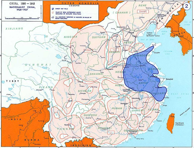
Overview map of Kuomingtang control over China.
From the History Department of the US Military Academy West Point - https://www.westpoint.edu/sites/default/files/inline-images/academics/academic_departments/history/Chinese%20civil%20war/ChineseCivilWar02.pdf
授權條款
此作品在美國屬於公有領域,因為其是由美國政府的官員或僱員,基於其個人公務目的製作的作品,參考美國法典第17篇第1章第105條。
注意︰本模板僅適用於美國聯邦政府的原創作品,不適用於任何美國州、屬地、聯邦個體、縣、市或任何次級政府的作品。本模板也不適用於1978年以後由美國郵政署出版的郵票圖案(參看美國版權局實踐綱領第313.6(C)(1)條)。也不適用於部分美國硬幣;參看美國鑄幣局使用條款。 |
 | |
| 此作品無已知的著作權限制,亦不受所有相關和鄰接的權利限制。 | ||
檔案歷史
點選日期/時間以檢視該時間的檔案版本。
| 日期/時間 | 縮圖 | 尺寸 | 用戶 | 備註 | |
|---|---|---|---|---|---|
| 目前 | 2006年12月16日 (六) 14:19 | | 1,141 × 870(183 KB) | Electionworld | {{ew|en|ChrisO}} Overview map of {{link|Kuomingtang}} control over China. From the History Department of the US Military Academy West Point - http://www.dean.usma.edu/history/web03/atlases/chinese%20civil%20war/chinese%20civil%20war%20pages/chinese%2 |
檔案用途
全域檔案使用狀況
以下其他 wiki 使用了這個檔案:
- ca.wikipedia.org 的使用狀況
- el.wikipedia.org 的使用狀況
- en.wikipedia.org 的使用狀況
- fi.wikipedia.org 的使用狀況
- ja.wikipedia.org 的使用狀況
- ko.wikipedia.org 的使用狀況
- lv.wikipedia.org 的使用狀況
- mk.wikipedia.org 的使用狀況
- ms.wikipedia.org 的使用狀況
- my.wikipedia.org 的使用狀況
- nl.wikipedia.org 的使用狀況
- sv.wikipedia.org 的使用狀況
- vi.wikipedia.org 的使用狀況