
File:Pollution over east China.jpg

預覽大小:782 × 600 像素。 其他解析度:313 × 240 像素 | 626 × 480 像素 | 1,002 × 768 像素 | 1,280 × 981 像素 | 2,560 × 1,963 像素 | 6,000 × 4,600 像素。
原始檔案 (6,000 × 4,600 像素,檔案大小:2.12 MB,MIME 類型:image/jpeg)
摘要
| 描述 |
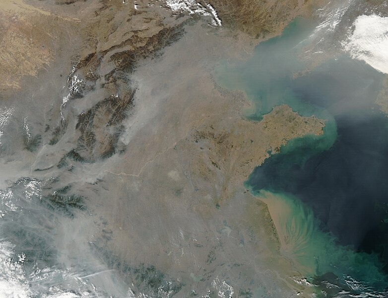
This true-color image over eastern China was acquired by the Moderate Resolution Imaging Spectroradiometer (MODIS), flying aboard NASA’s Aqua satellite, on Oct. 16, 2002 [1]. The scene reveals dozens of fires burning on the surface (red dots) and a thick pall of smoke and haze (greyish pixels) filling the skies overhead. Notice in the high-resolution version of this image how the smog fills the valleys and courses around the contours of the terrain in China’s hilly and mountainous regions. The terrain higher in elevation is less obscured by the smog than the lower lying plains and valleys in the surrounding countryside. This scene spans roughly from Beijing (near top center) to the Yangtze River, the mouth of which can be seen toward the bottom right. Toward the upper right corner, the Bo Hai Bay is rather obscured by the plume of pollution blowing eastward toward Korea and the Pacific Ocean. Toward the bottom right, the Yangtze River is depositing its brownish, sediment-laden waters into the Yellow Sea. |
| 來源 | |
| 作者 |
授權條款
| 本作品由NASA創作,屬於公有領域。根據NASA的版權政策:“NASA的創作除非另有聲明否則不受版權保護。”(參見:Template:PD-USGov/zh,NASA版權政策或JPL圖像使用政策) | ||
 |
警告:
|
原始上傳日誌
The original description page was here. All following user names refer to en.wikipedia.
- 2007-03-16 02:27 Kgrr 6000×4600×8 (2227952 bytes) This true-color image over eastern China was acquired by the Moderate Resolution Imaging Spectroradiometer (MODIS), flying aboard NASA’s Aqua satellite, on Oct. 16, 2002 [http://earthobservatory.nasa.gov/Newsroom/NewImages/images.php3?img_id=10795]. Th
檔案歷史
點選日期/時間以檢視該時間的檔案版本。
| 日期/時間 | 縮圖 | 尺寸 | 用戶 | 備註 | |
|---|---|---|---|---|---|
| 目前 | 2007年3月23日 (五) 10:52 | | 6,000 × 4,600(2.12 MB) | Liftarn | {{Information |Description=This true-color image over eastern China was acquired by the Moderate Resolution Imaging Spectroradiometer (MODIS), flying aboard NASA’s Aqua satellite, on Oct. 16, 2002 [http://earthobservatory.nasa.gov/Newsroom/NewImages/ima |
檔案用途
下列3個頁面有用到此檔案:
全域檔案使用狀況
以下其他 wiki 使用了這個檔案:
- ar.wikipedia.org 的使用狀況
- arz.wikipedia.org 的使用狀況
- ast.wikipedia.org 的使用狀況
- ca.wikipedia.org 的使用狀況
- cs.wikipedia.org 的使用狀況
- en.wikipedia.org 的使用狀況
- es.wikipedia.org 的使用狀況
- eu.wikipedia.org 的使用狀況
- fa.wikipedia.org 的使用狀況
- fi.wikipedia.org 的使用狀況
- fr.wikipedia.org 的使用狀況
- fy.wikipedia.org 的使用狀況
- id.wikipedia.org 的使用狀況
- it.wikipedia.org 的使用狀況
- ml.wikipedia.org 的使用狀況
- nl.wikipedia.org 的使用狀況
- no.wikipedia.org 的使用狀況
- oc.wikipedia.org 的使用狀況
- pl.wikipedia.org 的使用狀況
- pt.wikipedia.org 的使用狀況
- si.wikipedia.org 的使用狀況
- sq.wikibooks.org 的使用狀況
- ta.wikipedia.org 的使用狀況