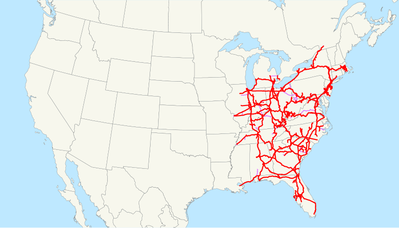
File:CSX Transportation system map.svg
外观

此SVG文件的PNG预览的大小:800 × 457像素。 其他分辨率:320 × 183像素 | 640 × 366像素 | 1,024 × 585像素 | 1,280 × 731像素 | 2,560 × 1,463像素 | 1,400 × 800像素。
原始文件 (SVG文件,尺寸为1,400 × 800像素,文件大小:1.31 MB)
文件历史
点击某个日期/时间查看对应时刻的文件。
| 日期/时间 | 缩略图 | 大小 | 用户 | 备注 | |
|---|---|---|---|---|---|
| 当前 | 2009年2月23日 (一) 13:05 |  | 1,400 × 800(1.31 MB) | NE2 | Changed the display of lines owned by the government for the purposes of passenger rail, so that if CSX is the primary freight operator it is not shown as trackage rights. |
| 2009年1月28日 (三) 13:53 |  | 1,400 × 800(1.29 MB) | NE2 | == Summary == This is a map of CSX Transportation as of 2009, with trackage rights in purple. Some minor lines are missing. Email me if you would like a copy of the GIS data I created (modified from Bureau |
文件用途
以下页面使用本文件:
全域文件用途
以下其他wiki使用此文件:
- da.wikipedia.org上的用途
- de.wikipedia.org上的用途
- en.wikipedia.org上的用途
- es.wikipedia.org上的用途
- fi.wikipedia.org上的用途
- fr.wikipedia.org上的用途
- hu.wikipedia.org上的用途
- id.wikipedia.org上的用途
- it.wikipedia.org上的用途
- ja.wikipedia.org上的用途
- ko.wikipedia.org上的用途
- nl.wikipedia.org上的用途
- no.wikipedia.org上的用途
- pt.wikipedia.org上的用途
- ru.wikipedia.org上的用途
- simple.wikipedia.org上的用途
- www.wikidata.org上的用途

