
File:Gibraltar map-en-edit2.svg

此SVG文件的PNG预览的大小:385 × 600像素。 其他分辨率:154 × 240像素 | 308 × 480像素 | 493 × 768像素 | 657 × 1,024像素 | 1,314 × 2,048像素 | 1,000 × 1,558像素。
原始文件 (SVG文件,尺寸为1,000 × 1,558像素,文件大小:1.46 MB)
摘要
|
| 相机位置 | | 在以下服务上查看本图像和附近其他图像: OpenStreetMap |
|---|
| 描述 |
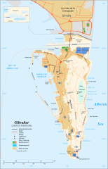
English: Map in English of Gibraltar
Français : Carte en anglais de Gibraltar |
| 日期 | |
| 来源 |
English: adapted from: Image:Gibraltar map-en.svg
Français : Création personnelle ;
|
| 作者 | Original by Eric Gaba (Sting), label/legend edits by Jeff Dahl |
| 授权 (二次使用本文件) |
Attribution and Share-Alike required |
| 其他版本 |
|


|
This SVG file contains embedded text that can be translated into your language, using any capable SVG editor, text editor or the SVG Translate tool. For more information see: About translating SVG files. |
许可协议
我,本作品著作权人,特此采用以下许可协议发表本作品:

|
已授权您依据自由软件基金会发行的无固定段落及封面封底文字(Invariant Sections, Front-Cover Texts, and Back-Cover Texts)的GNU自由文件许可协议1.2版或任意后续版本的条款,复制、传播和/或修改本文件。该协议的副本请见“GNU Free Documentation License”。 |
This file is licensed under the Creative Commons Attribution-Share Alike 4.0 International, 3.0 Unported, 2.5 Generic, 2.0 Generic and 1.0 Generic license.
- 您可以自由地:
- 共享 – 复制、发行并传播本作品
- 修改 – 改编作品
- 惟须遵守下列条件:
- 署名 – 您必须对作品进行署名,提供授权条款的链接,并说明是否对原始内容进行了更改。您可以用任何合理的方式来署名,但不得以任何方式表明许可人认可您或您的使用。
- 相同方式共享 – 如果您再混合、转换或者基于本作品进行创作,您必须以与原先许可协议相同或相兼容的许可协议分发您贡献的作品。
您可以选择您需要的许可协议。
文件历史
点击某个日期/时间查看对应时刻的文件。
| 日期/时间 | 缩略图 | 大小 | 用户 | 备注 | |
|---|---|---|---|---|---|
| 当前 | 2017年4月5日 (三) 16:36 | | 1,000 × 1,558(1.46 MB) | RaviC | + University, Ferry terminal (& Route), Cathedral |
| 2007年12月11日 (二) 18:52 |  | 1,000 × 1,558(1.79 MB) | Jeff Dahl | resized 1200 down to 1000px wide, minor label fixes | |
| 2007年12月10日 (一) 17:08 |  | 1,200 × 1,870(1.78 MB) | Jeff Dahl | {{inkscape}} {{Location|36|08|00|N|5|21|00|W|type:city_scale:50000}} {{Information |Description=Map in English of Gibraltar |Source=adapted from: Image:Gibraltar map-en.svg <br/>Map created using screenshots of [[:en:Google Ea |
文件用途
全域文件用途
以下其他wiki使用此文件:
- af.wikipedia.org上的用途
- ar.wikipedia.org上的用途
- av.wikipedia.org上的用途
- azb.wikipedia.org上的用途
- bg.wikipedia.org上的用途
- bn.wikipedia.org上的用途
- bs.wikipedia.org上的用途
- ceb.wikipedia.org上的用途
- Plantilya:Location map Gibraltar
- Signal Hill
- White Rock
- Sandy Bay
- Roca Blanca
- Ailsa Craig
- Passage Point
- El Peñón
- The Rock
- Middle Hill
- Gibraltar (pagklaro)
- Rock of Gibraltar
- Deadmans Beach
- Eastern Beach
- Western Beach
- Punta Pasaje
- Punta Europa
- La Roca
- Governor’s Beach
- Camp Bay
- Europa Point
- Gibraltar Bay
- Cerro de Enmedio
- Blackstrap Bay
- Caledonian Canal
- Great Europa Point
- Gibilterra
- White Rock (bato sa Gyibraltar)
- Western Beach (lapyahan sa Gyibraltar)
- Signal Hill (bungtod sa Gyibraltar)
- Sandy Bay North
- Sandy Bay (luuk)
- Saint Michael's Cave
- Saint Abb's Head
- North Gorge
- Middle Hill (bungtod sa Gyibraltar)
- Mediterranean Steps
- Martin's Cave
- Europa Point (punta sa Gyibraltar)
- The Lido
- Levant Cave
- H.M.S. Rooke
查看本文件的更多全域用途。