跳转到内容

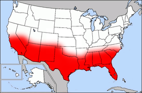
File:Map of USA highlighting Sun Belt.png

页面内容不支持其他语言。
这个文件来自维基共享资源
维基百科,自由的百科全书

Map_of_USA_highlighting_Sun_Belt.png (280 × 183像素,文件大小:40 KB,MIME类型:image/png


Public domain map courtesy of The General Libraries, The University of Texas at Austin, modified (by • Benc • 00:36, 13 Aug 2004 (UTC) to highlight regions.

Originally uploaded onto English Wikipedia 00:36, 13 August 2004 by Benc

English: This map come from the map collection of University of Texas, specifically from: [{{{url}}} {{{title}}}, from {{{origin}}}]. It is in the public domain (http://www.lib.utexas.edu/maps/faq.html#3.html).
Français : Cette carte est issue issu de la collection de cartes de l'université du Texas et plus précisément de celle-ci : [{{{url}}} {{{title}}}, from {{{origin}}}]. Elle se trouve dans dans le domaine public (http://www.lib.utexas.edu/maps/faq.html#3.html).
Nederlands: Deze afbeelding is afkomstig uit de kaartencollectie van de University of Texas. Deze kaarten bevinden zich in het publiek domein (http://www.lib.utexas.edu/maps/faq.html#3.html).
Public domain

本作品在其来源国以及其他著作权期限是作者逝世后70年或以下的国家和地区属于公有领域


你必须增加美国公有领域标签显示为何这个作品在美国属于公有领域。
本文件已被确认为免除已知的著作权法限制(包括所有相关权利)。

文件历史

点击某个日期/时间查看对应时刻的文件。

日期/时间缩⁠略⁠图大小用户备注
当前2006年9月27日 (三) 17:412006年9月27日 (三) 17:41版本的缩略图280 × 183(40 KB)Mr Bullitt~commonswikiPublic domain map courtesy of [http://www.lib.utexas.edu/ The General Libraries, The University of Texas at Austin], modified (by • Benc • 00:36, 13 Aug 2004 (UTC)) to highlight regions. Originally uploaded

没有页面使用本文件。

全域文件用途

以下其他wiki使用此文件: