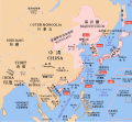
File:Mengjiang map 1939.svg
外观

此SVG文件的PNG预览的大小:634 × 387像素。 其他分辨率:320 × 195像素 | 640 × 391像素 | 1,024 × 625像素 | 1,280 × 781像素 | 2,560 × 1,563像素。
原始文件 (SVG文件,尺寸为634 × 387像素,文件大小:2.23 MB)
文件历史
点击某个日期/时间查看对应时刻的文件。
| 日期/时间 | 缩略图 | 大小 | 用户 | 备注 | |
|---|---|---|---|---|---|
| 当前 | 2023年9月16日 (六) 14:43 |  | 634 × 387(2.23 MB) | KajenCAT | File uploaded using svgtranslate tool (https://svgtranslate.toolforge.org/). Added translation for ca. |
| 2023年9月16日 (六) 13:08 |  | 634 × 387(2.23 MB) | KajenCAT | File uploaded using svgtranslate tool (https://svgtranslate.toolforge.org/). Added translation for ca. | |
| 2021年11月2日 (二) 17:25 |  | 634 × 387(2.2 MB) | Nv7801 | Chungking, Hainan | |
| 2021年11月2日 (二) 17:22 |  | 634 × 387(2.2 MB) | Nv7801 | Saipan | |
| 2010年8月27日 (五) 01:39 |  | 634 × 387(2.21 MB) | Splittist | No reason for Xinjiang to have separate borders from China | |
| 2009年5月30日 (六) 23:35 |  | 634 × 387(2.21 MB) | SelfQ~commonswiki | Cluttering and removal of key elements is not acceptable. If you want a Chineese version please upload on under its own file name. | |
| 2009年5月17日 (日) 10:43 |  | 1,300 × 1,201(864 KB) | Xiamipi | 增加中文说明 | |
| 2008年8月21日 (四) 02:58 |  | 634 × 387(2.21 MB) | Emok | {{Information |Description={{en|1=A map of Mengjiang, 1939-09-01. Dates shown indicate the approximate year that the various powers gain control of their possessions. Japanese control of territory in China was tenuous.}} |Source=*[[:Image:Pacific_Area_-_T |
文件用途
以下页面使用本文件:
全域文件用途
以下其他wiki使用此文件:
- ca.wikipedia.org上的用途
- cs.wikipedia.org上的用途
- de.wikipedia.org上的用途
- en.wikipedia.org上的用途
- fi.wikipedia.org上的用途
- id.wikipedia.org上的用途
- it.wikipedia.org上的用途
- mk.wikipedia.org上的用途
- nl.wikipedia.org上的用途
- no.wikipedia.org上的用途
- pl.wikipedia.org上的用途
- simple.wikipedia.org上的用途


