
File:Plan Centre Spatial Guyanais-en.svg

此SVG文件的PNG预览的大小:648 × 599像素。 其他分辨率:260 × 240像素 | 519 × 480像素 | 831 × 768像素 | 1,108 × 1,024像素 | 2,215 × 2,048像素 | 1,060 × 980像素。
原始文件 (SVG文件,尺寸为1,060 × 980像素,文件大小:472 KB)

|
This SVG file contains embedded text that can be translated into your language, using any capable SVG editor, text editor or the SVG Translate tool. For more information see: About translating SVG files. |
摘要
| 描述 |
[]
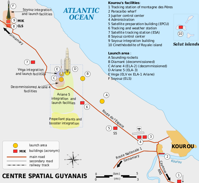
Català: Mapa de la infraestructura dels llançadors Ariane i Vega al port espacial europeu (Centre Spatial Guyanais o CSG), Kourou, Guaiana Francesa Deutsch: Karte der Infrastruktur der Ariana- und Vega-Startrampen auf dem Weltraumbahnhof Kourou, Französisch-Guayana English: Map of the infrastructure for the Ariane and Vega launchers at the Europe's Spaceport (Centre Spatial Guyanais or CSG) , Kourou, French Guiana Français : Carte des installations du Centre Spatial Guyanais (CSG) de Kourou, Guyane Francaise (France) Magyar: A Guyanai Űrközpont térképe Nederlands: Kaart van de Europese lanceerbasis (Centre Spatial Guyanais of CSG) in Kourou, Frans Guiana Русский: План космодрома «Куру» во Французской Гвиане |
||
| 日期 | |||
| 来源 | 自己的作品 | ||
| 作者 | Pline | ||
| 其他版本 |
[]
|


许可协议
我,本作品著作权人,特此采用以下许可协议发表本作品:

|
已授权您依据自由软件基金会发行的无固定段落及封面封底文字(Invariant Sections, Front-Cover Texts, and Back-Cover Texts)的GNU自由文件许可协议1.2版或任意后续版本的条款,复制、传播和/或修改本文件。该协议的副本请见“GNU Free Documentation License”。 |
- 您可以自由地:
- 共享 – 复制、发行并传播本作品
- 修改 – 改编作品
- 惟须遵守下列条件:
- 署名 – 您必须对作品进行署名,提供授权条款的链接,并说明是否对原始内容进行了更改。您可以用任何合理的方式来署名,但不得以任何方式表明许可人认可您或您的使用。
- 相同方式共享 – 如果您再混合、转换或者基于本作品进行创作,您必须以与原先许可协议相同或相兼容的许可协议分发您贡献的作品。
您可以选择您需要的许可协议。
文件历史
点击某个日期/时间查看对应时刻的文件。
| 日期/时间 | 缩略图 | 大小 | 用户 | 备注 | |
|---|---|---|---|---|---|
| 当前 | 2016年3月4日 (五) 18:08 | | 1,060 × 980(472 KB) | Manlleus | Sorry again! |
| 2016年3月4日 (五) 18:06 |  | 1,060 × 980(524 KB) | Manlleus | Reverted to version as of 13:37, 13 April 2009 (UTC) - Sorry, was a big error! | |
| 2016年2月1日 (一) 20:51 |  | 1,060 × 980(524 KB) | Manlleus | Editing SVG source code using User:Rillke/SVGedit.js; upload handled by User:Rillke/MwJSBot.js | |
| 2009年4月13日 (一) 13:37 |  | 1,060 × 980(524 KB) | Pline | {{Information |Description={{en|1=Map of the infrastructure for the Ariane and Vega launchers at the Europe's Spaceport (Centre Spatial Guyanais or CSG) , Kourou, French Guiana}} {{fr|1=Carte des installations du Centre Spatial Guyanais (CSG) de Kourou, G |
文件用途
以下页面使用本文件:
全域文件用途
以下其他wiki使用此文件:
- el.wikipedia.org上的用途
- en.wikipedia.org上的用途
- eo.wikipedia.org上的用途
- es.wikipedia.org上的用途
- et.wikipedia.org上的用途
- fi.wikipedia.org上的用途
- he.wikipedia.org上的用途
- id.wikipedia.org上的用途
- it.wikipedia.org上的用途
- ja.wikipedia.org上的用途
- kn.wikipedia.org上的用途
- lv.wikipedia.org上的用途
- ms.wikipedia.org上的用途
- no.wikipedia.org上的用途
- ro.wikipedia.org上的用途
- sk.wikipedia.org上的用途
- sl.wikipedia.org上的用途
- sr.wikipedia.org上的用途
- uk.wikipedia.org上的用途
- vi.wikipedia.org上的用途