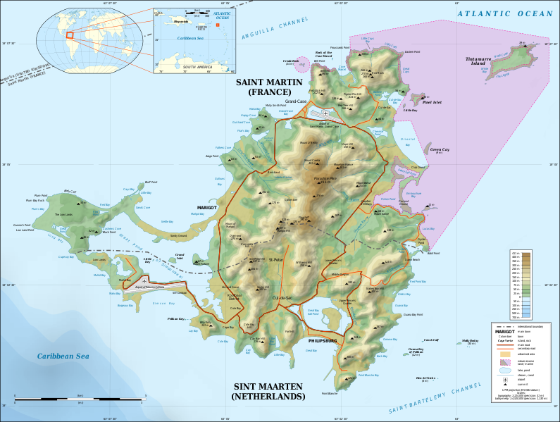
File:Saint-Martin Island topographic map-en.svg

此SVG文件的PNG预览的大小:795 × 599像素。 其他分辨率:319 × 240像素 | 637 × 480像素 | 1,019 × 768像素 | 1,280 × 965像素 | 2,560 × 1,930像素 | 2,600 × 1,960像素。
原始文件 (SVG文件,尺寸为2,600 × 1,960像素,文件大小:1.57 MB)
文件历史
点击某个日期/时间查看对应时刻的文件。
| 日期/时间 | 缩略图 | 大小 | 用户 | 备注 | |
|---|---|---|---|---|---|
| 当前 | 2015年10月17日 (六) 22:55 |  | 2,600 × 1,960(1.57 MB) | Sting | Using NASA SRTM 1 topographic data ; now only the shaded relief is raster |
| 2009年5月5日 (二) 20:39 |  | 2,600 × 1,960(1.45 MB) | Sting | == Summary == {{Location|18|04|00|N|63|03|30|W|scale:100000}} <br/> {{Information |Description={{en|Topographic map in English of the Caribbean island of Saint-Martin / Sint Maarten, divided between French and Dutch halves.<br/> ''Not |
文件用途
以下页面使用本文件:
全域文件用途
以下其他wiki使用此文件:
- ar.wikipedia.org上的用途
- bn.wikipedia.org上的用途
- bs.wikipedia.org上的用途
- el.wikipedia.org上的用途
- en.wikipedia.org上的用途
- eo.wikipedia.org上的用途
- es.wikipedia.org上的用途
- es.wikivoyage.org上的用途
- fa.wikipedia.org上的用途
- gl.wikipedia.org上的用途
- hr.wikipedia.org上的用途
- hu.wikipedia.org上的用途
- ia.wikipedia.org上的用途
- id.wikipedia.org上的用途
- is.wikipedia.org上的用途
- it.wikipedia.org上的用途
- ka.wikipedia.org上的用途
- nl.wikipedia.org上的用途
- pt.wikipedia.org上的用途
- ru.wikipedia.org上的用途
- sl.wikipedia.org上的用途
- sr.wikipedia.org上的用途
- su.wikipedia.org上的用途
- sw.wikipedia.org上的用途
- ta.wikipedia.org上的用途
- uk.wikipedia.org上的用途
- xmf.wikipedia.org上的用途
- zea.wikipedia.org上的用途


