
File:Saint Helena Island.jpg

原始文件 (1,440 × 1,080像素,文件大小:634 KB,MIME类型:image/jpeg)
摘要

|
根据最有价值图像标准,这张图像被评定为在Saint Helena Island范畴内最有价值的共享资源图像。你可以在Commons:Valued image candidates/Saint Helena Island.jpg参看它的提名。 |
| 描述 |
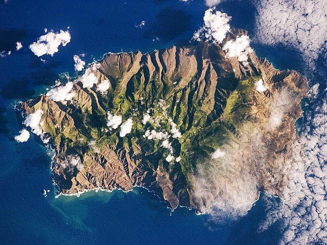
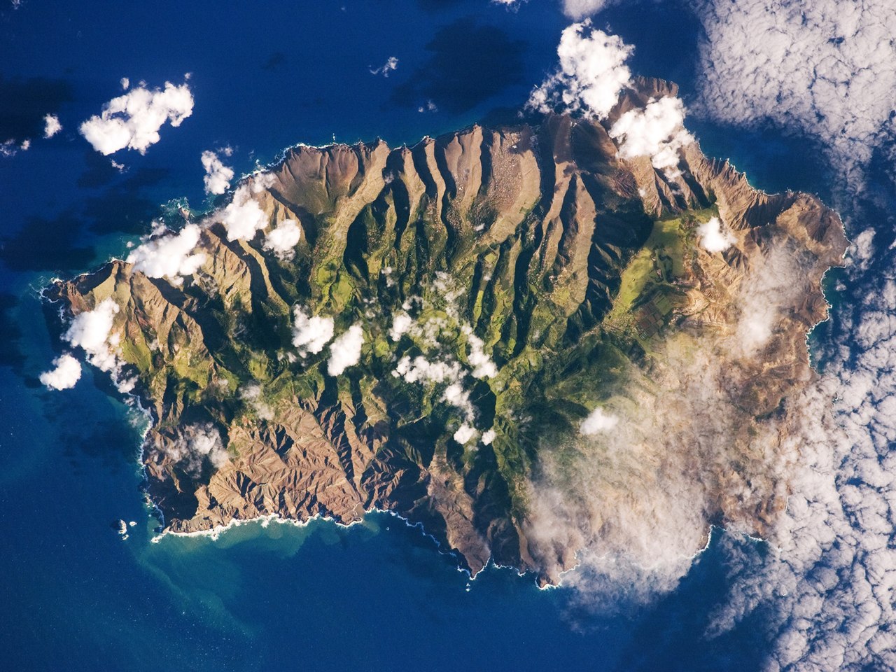
English: This astronaut photograph shows the island’s sharp peaks and deep ravines; the rugged topography results from erosion of the volcanic rocks that make up the island. The change in elevation from the coast to the interior creates a climate gradient. The higher, wetter centre is covered with green vegetation, whereas the lower coastal areas are drier and hotter, with little vegetation cover.
Français : Photo de l'île de Sainte Hélène prise par un astronaute de la NASA. On peut voir les pics élevés de l'île et ses ravines profondes. Cette topographie accidentée résulte de l'action de l'érosion sur les roches volcaniques dont l'île est constituée. Le changement d'élévation entre la périphérie et le centre de l'île créé un gradient climatique: le sommet est plus frais et humide, il est couvert de végétation. Les côtes, plus chaudes et sèches, laissent apparaitre la roche nue.
|
||||||||||||||||||||||||||||||||||||||||||||||||||||||
| 日期 | |||||||||||||||||||||||||||||||||||||||||||||||||||||||
| 来源 | NASA Earth Observatory | ||||||||||||||||||||||||||||||||||||||||||||||||||||||
| 作者 | This image was taken by the NASA Expedition 19 crew. | ||||||||||||||||||||||||||||||||||||||||||||||||||||||
| 其他版本 |
|
||||||||||||||||||||||||||||||||||||||||||||||||||||||

| 相机位置 | | 在以下服务上查看本图像和附近其他图像: OpenStreetMap |
|---|
This photograph was acquired with a Nikon 2DXs digital camera fitted with a 400 mm lens, and is provided by the ISS Crew Earth Observations experiment and Image Science & Analysis Laboratory, Johnson Space Centre.
Deutsch: Dieses Bild wurde als Bild der Woche auf der tschechischen Wikipedia für die 5 Woche ausgewählt, 2016. English: This image was selected as a picture of the week on the Czech Wikipedia for 5th week, 2016. Français : Cette image est sélectionnée en tant qu’image de la semaine sur la Wikipédia Tchèque pour la 5e semaine de 2016. Italiano: Questa immagine è stata selezionata come Immagine della settimana su Wikipedia in ceco per la V settimana del 2016. Македонски: Сликава е избрана за слика на неделата на чешката Википедија за V недела од 2016 година. Русский: Эта иллюстрация была выбрана изображением недели в чешском разделе «Википедии» для недели номер 5 2016 года. Українська: Ця ілюстрація була вибрана зображенням тижня в чеському розділі «Вікіпедії» для тижня номер 5, 2016 року. |
许可协议
| 本文件完全由NASA创作,在美国属于公有领域。根据NASA的版权方针,NASA的材料除非另有声明否则不受版权保护。(参见Template:PD-USGov/zh、NASA版权方针页面或JPL图片使用方针。) | ||
 |
警告:
|
| 注解 | 该图片含有注解:在维基媒体共享资源上查看注解 |
文件历史
点击某个日期/时间查看对应时刻的文件。
| 日期/时间 | 缩略图 | 大小 | 用户 | 备注 | |
|---|---|---|---|---|---|
| 当前 | 2015年3月23日 (一) 11:28 | | 1,440 × 1,080(634 KB) | Julian Herzog | Reverted to version as of 18:00, 19 March 2015, rotation was done then. |
| 2015年3月20日 (五) 08:00 |  | 1,440 × 1,080(634 KB) | SteinsplitterBot | Bot: Image rotated by 180° | |
| 2015年3月19日 (四) 18:00 |  | 1,440 × 1,080(634 KB) | SteinsplitterBot | Bot: Image rotated by 180° | |
| 2009年6月15日 (一) 09:40 |  | 1,440 × 1,080(622 KB) | Originalwana | {{Information |Description={{en|1=This astronaut photograph shows the island’s sharp peaks and deep ravines; the rugged topography results from erosion of the volcanic rocks that make up the island. The change in elevation from the coast to the interior |
文件用途
以下3个页面使用本文件:
全域文件用途
以下其他wiki使用此文件:
- als.wikipedia.org上的用途
- ar.wikipedia.org上的用途
- arz.wikipedia.org上的用途
- ast.wikipedia.org上的用途
- az.wikipedia.org上的用途
- be.wikipedia.org上的用途
- bg.wikipedia.org上的用途
- br.wikipedia.org上的用途
- bs.wikipedia.org上的用途
- ca.wikipedia.org上的用途
- ceb.wikipedia.org上的用途
- ce.wikipedia.org上的用途
- co.wikipedia.org上的用途
- cs.wikipedia.org上的用途
- da.wikipedia.org上的用途
- de.wikipedia.org上的用途
- en.wikipedia.org上的用途
- en.wikiversity.org上的用途
- eo.wikipedia.org上的用途
- es.wikipedia.org上的用途
- es.wiktionary.org上的用途
- fi.wiktionary.org上的用途
- frp.wikipedia.org上的用途
- fr.wikipedia.org上的用途
- fr.wikivoyage.org上的用途
- ga.wikipedia.org上的用途
- gl.wikipedia.org上的用途
- he.wikipedia.org上的用途
- hy.wikipedia.org上的用途
- ig.wikipedia.org上的用途
- it.wikipedia.org上的用途
查看本文件的更多全域用途。