跳转到内容

File:Arab population israel 2000 en.png

页面内容不支持其他语言。
这个文件来自维基共享资源
维基百科,自由的百科全书

原始文件 (692 × 1,575像素,文件大小:182 KB,MIME类型:image/png


摘要

描述
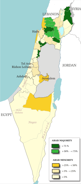
English: Map of the officials 50 "natural regions" of Israel, with their proportions of arab population. The map includ the Golan heights and east Jerusalem, two areas annexed by Israel, annexions not recognize by UNO. The map is based on the demographic situation 2000, and is based upon the arab population in Israel [PDF], a publication (Statistilite N°27) of the israeli Center Bureau of Statistics (CBS) diffused in november 2002.
Français : Carte des 50 "régions naturelles" officiellement reconnues par l'état, subdivision des 15 sous-districts, avec la proportion de population arabe. Cette carte inclue Jérusalem-Est et le plateau du Golan, tous deux annexés par Israël, mais dont l'annexion n'est pas reconnue par l'ONU. La carte est basée sur la situation de la population en l'an 2000, et est inspirée de the arab population in Israel [PDF], une publication (Statistilite N°27) du Center Bureau of Statistics israélien (CBS) diffusée en novembre 2002.
日期
来源 Own work, derivative work of: File:Israel population density.png
作者 Christophe cagé
其他版本 File:Arabe population israel 2000 fr.png

许可协议

© 本文件的著作权人,Israel Central Bureau of Statistics,允许任何人在适当地表明著作权人的姓名的前提下,以任何目的使用本文件。传播,演绎作品,商业用途及所有其他用途被允许。
署名:
The Central Bureau of Statistics (CBS), {{{filename}}}, ({{{access-date}}}), [{{{link}}} available online] copied and distributed as is in accordance with the CBS license.

{{{template}}} According to the CBS license, you may not make the following use of the Information, whether by positive act or by omission:
  • present the Information in a misleading manner;
  • present the Information in a way that suggests that the Central Bureau of Statistics, or the State of Israel, supports or endorses you or your use of the Information;
  • make use of the Information in a manner that breaches any applicable law;
  • make use of the Information in a manner that infringes a person's privacy, including merging the Information with other sources of information with the intent of attempting to identify any individual person, business or organization;
  • present the Information in such a manner that gives the appearance that you may have received, or had access to, information held by the Office about any identifiable individual person, business or organization.
我,本作品著作权人,特此采用以下许可协议发表本作品:
GNU head 已授权您依据自由软件基金会发行的无固定段落及封面封底文字(Invariant Sections, Front-Cover Texts, and Back-Cover Texts)的GNU自由文件许可协议1.2版或任意后续版本的条款,复制、传播和/或修改本文件。该协议的副本请见“GNU Free Documentation License”。
w:zh:知识共享
署名 相同方式共享
本文件采用知识共享署名-相同方式共享3.0 未本地化版本2.5 通用2.0 通用1.0 通用许可协议授权。
您可以自由地:
  • 共享 – 复制、发行并传播本作品
  • 修改 – 改编作品
惟须遵守下列条件:
  • 署名 – 您必须对作品进行署名,提供授权条款的链接,并说明是否对原始内容进行了更改。您可以用任何合理的方式来署名,但不得以任何方式表明许可人认可您或您的使用。
  • 相同方式共享 – 如果您再混合、转换或者基于本作品进行创作,您必须以与原先许可协议相同或相兼容的许可协议分发您贡献的作品。
您可以选择您需要的许可协议。

说明

添加一行文字以描述该文件所表现的内容

此文件中描述的项目

描绘内容

创作作者 简体中文(已转写)

某些值没有维基数据项目

客体角色 简体中文(已转写):​摄影师 简体中文(已转写)
维基媒体用户名 简体中文(已转写):​Christophe cagé
作者姓名字符串 简体中文(已转写):​Christophe cagé

版权状态 简体中文(已转写)

版权所有 简体中文(已转写)

媒体类型 简体中文(已转写)

image/png

校验和 简体中文(已转写)

5afc0b91dfe8d983a85af862f3a58ec981a8a743

断定方法:​SHA-1 简体中文(已转写)

数据大小 简体中文(已转写)

186,138 字节

1,575 像素

692 像素

文件历史

点击某个日期/时间查看对应时刻的文件。

日期/时间缩⁠略⁠图大小用户备注
当前2014年7月15日 (二) 13:482014年7月15日 (二) 13:48版本的缩略图692 × 1,575(182 KB)Hruska~commonswikiReverted to version as of 08:23, 22 February 2009
2014年7月15日 (二) 13:472014年7月15日 (二) 13:47版本的缩略图692 × 1,575(182 KB)Hruska~commonswikiReverted to version as of 08:23, 22 February 2009 Revert Edit, The Golan and East Jerusalem de facto Israel, Syria giving Status qo
2014年7月15日 (二) 13:462014年7月15日 (二) 13:46版本的缩略图692 × 1,575(182 KB)Hruska~commonswikiReverted to version as of 08:23, 22 February 2009
2009年4月21日 (二) 15:382009年4月21日 (二) 15:38版本的缩略图692 × 1,575(165 KB)MeteorMaker~commonswiki{{Information |Description={{en|1=Map of the officials 50 "natural regions" of Israel, with their proportions of arab population. The map includ the Golan heights and east Jerusalem, two areas annexed by Israel, annexions not recognize by UNO. The map is
2009年2月22日 (日) 08:232009年2月22日 (日) 08:23版本的缩略图692 × 1,575(182 KB)Christophe cagé{{Information |Description={{en|1=x}} {{fr|1=x}} |Source=travail personnel (own work) |Author=Christophe cagé |Date=22 february 2009 |Permission=SEE LICENSE |other_versions= }} <!--{{ImageUpload|full}}-->

以下页面使用本文件:

全域文件用途

以下其他wiki使用此文件:

元数据