
File:Curtis and Cheeseman Islands from north.png

本预览的尺寸:800 × 170像素。 其他分辨率:1,050 × 223像素。
原始文件 (1,050 × 223像素,文件大小:317 KB,MIME类型:image/png)
摘要
| 描述 |
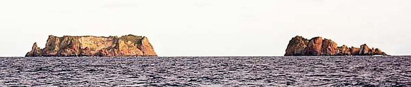
English: Picture of Curtis and Cheeseman Islands, Kermadec Islands, north of New Zealand |
| 日期 | |
| 来源 | Sailing Directions (Enroute), Pub 127 Pacific West |
| 作者 | National Geospatial-Intelligence Agency |
许可协议
This image is a work of the United States National Geospatial-Intelligence Agency or one of its predecessor agencies. As a work of the U.S. federal government, the image is in the public domain.
|
 |
文件历史
点击某个日期/时间查看对应时刻的文件。
| 日期/时间 | 缩略图 | 大小 | 用户 | 备注 | |
|---|---|---|---|---|---|
| 当前 | 2009年12月6日 (日) 21:44 | 1,050 × 223(317 KB) | Ratzer | {{Information |Description={{en|1=picture of Curtis and Cheeseman Islands, Kermadec Islands, north of New Zealand}} |Source=Sailing Directions (Enroute), Pub 127 Pacific West |Author=National Geospatial-Intelligence Agency |Date=2000 |Permission= |other_v |
文件用途
全域文件用途
以下其他wiki使用此文件:
- ceb.wikipedia.org上的用途
- de.wikipedia.org上的用途
- en.wikipedia.org上的用途
- fa.wikipedia.org上的用途
- fr.wikipedia.org上的用途
- it.wikipedia.org上的用途
- www.wikidata.org上的用途