跳转到内容

File:Mjo north america rain.png

页面内容不支持其他语言。
这个文件来自维基共享资源
维基百科,自由的百科全书

原始文件(556 × 749像素,文件大小:28 KB,MIME类型:image/png


描述
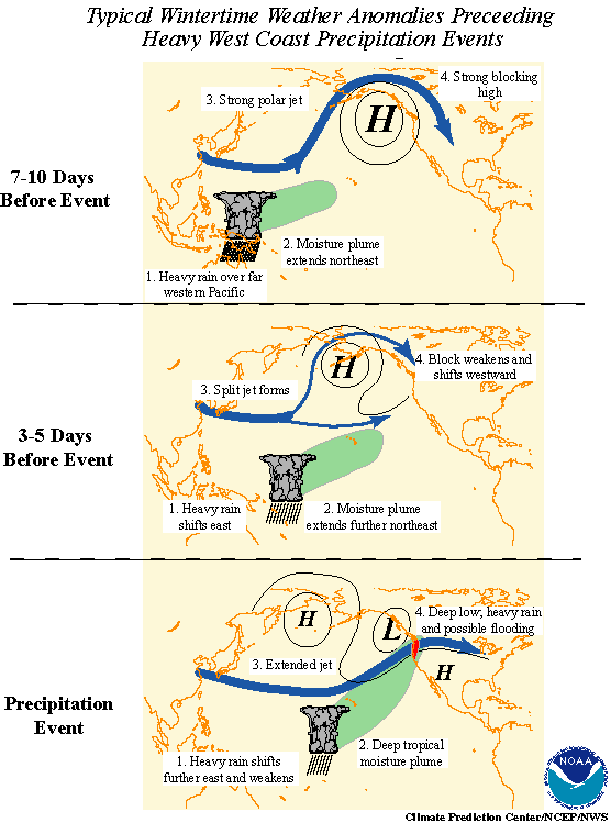
English: Madden-Julian oscillation effects upon North American weather patterns. Eastward-moving tropical rainfall circulation drives north Pacific Ocean atmospheric circulation changes.

Here are the 3 progressive steps:

  • 7-10 days prior to the heavy precipitation event, heavy tropical rainfall associated with the MJO shifts eastward from the eastern Indian Ocean to the western tropical Pacific. A moisture plume extends northeastward from the western tropical Pacific towards the general vicinity of the Hawaiian Islands. A strong blocking anticyclone is located in the Gulf of Alaska with a strong polar jet stream around its northern flank.
  • 3-5 days prior to the heavy precipitation event, heavy tropical rainfall shifts eastward towards the date line and begins to diminish. The associated moisture plume extends further to the northeast, often traversing the Hawaiian Islands. The strong blocking high weakens and shifts westward. A split in the North Pacific jet stream develops, characterized by an increase in the amplitude and areal extent of the upper tropospheric westerly zonal winds on the southern flank of the block and a decrease on its northern flank. The tropical and extratropical circulation patterns begin to "phase", allowing a developing midlatitude trough to tap the moisture plume extending from the deep tropics.
  • As the pattern of enhanced tropical rainfall continues to shift further to the east and weaken, the deep tropical moisture plume extends from the subtropical central Pacific into the midlatitude trough now located off the west coast of North America. The jet stream at upper levels extends across the North Pacific with the mean jet position entering North America in the northwestern United States. Deep low pressure located near the Pacific Northwest coast can bring up to several days of heavy rain and possible flooding. These events are often referred to as "pineapple express" events, so named because a significant amount of the deep tropical moisture traverses the Hawaiian Islands on its way towards western North America.
日期
来源 NOAA in article Monitoring Interseasonal Oscillations
作者 Pierre_cb
授权
(二次使用本文件)
Public domain
本图像属于公有领域,因该作品最初来自于美国国家海洋和大气管理局职员的职务作品。

العربية  čeština  Deutsch  Zazaki  English  español  eesti  suomi  français  hrvatski  magyar  italiano  日本語  한국어  македонски  മലയാളം  Plattdüütsch  Nederlands  polski  português  română  русский  sicilianu  slovenščina  Türkçe  Tiếng Việt  简体中文  繁體中文  +/−

其他版本 French in File:Mjo north america rain f.png.
此图片可使用矢量图形重新创建为SVG文件。这具有很多好处;更多信息请参见共享资源:待清理媒体。如果存在此图片的SVG格式,请将其上传,然后将此模板替换为{{vector version available|新图片名称}}


建议您将SVG命名为“Mjo north america rain.svg”,这样在使用Vector version available(或Vva)模板时就不需要填写新图片名称参数。

文件历史

点击某个日期/时间查看对应时刻的文件。

日期/时间缩⁠略⁠图大小用户备注
当前2010年8月25日 (三) 16:012010年8月25日 (三) 16:01版本的缩略图556 × 749(28 KB)Pierre cbEnglish version
2006年12月24日 (日) 01:352006年12月24日 (日) 01:35版本的缩略图557 × 667(50 KB)Pierre cb{{Information |Description=Madden-Julian oscillation effects upon North American weather patterns. Eastward-moving tropical rainfall circulation drives north Pacific Ocean atmospheric circulation changes. |Source= [http://www.cpc.ncep.noaa.gov/p

以下页面使用本文件:

全域文件用途

以下其他wiki使用此文件: