
File:Yom Kippur War map.svg

此SVG文件的PNG预览的大小:398 × 599像素。 其他分辨率:159 × 240像素 | 319 × 480像素 | 510 × 768像素 | 680 × 1,024像素 | 1,361 × 2,048像素 | 400 × 602像素。
原始文件 (SVG文件,尺寸为400 × 602像素,文件大小:43 KB)
摘要
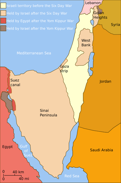
| 描述 | Self-made line drawing of a map of Israel's territories before and after the Yom Kippur War. |
| 日期 | |
| 来源 | Source of line drawing: Now-deleted image Jom kippur war.jpg which was originally uploaded to the polish Wikipedia at Jom kippur war.jpg -- Ministerstwo Spraw Zagranicznych Izraela, za zgodÄ… Ambasady Izraela w Polsce. -- Ministry of Foreign Affairs of Israel, with the permission of Israel Embassy in Poland |
| 作者 | Raul654 |
| 其他版本 |
[]
|
| SVG开发 |


|
This SVG file contains embedded text that can be translated into your language, using any capable SVG editor, text editor or the SVG Translate tool. For more information see: About translating SVG files. |
许可协议
本文件采用知识共享署名-相同方式共享 2.5 通用许可协议授权。
- 您可以自由地:
- 共享 – 复制、发行并传播本作品
- 修改 – 改编作品
- 惟须遵守下列条件:
- 署名 – 您必须对作品进行署名,提供授权条款的链接,并说明是否对原始内容进行了更改。您可以用任何合理的方式来署名,但不得以任何方式表明许可人认可您或您的使用。
- 相同方式共享 – 如果您再混合、转换或者基于本作品进行创作,您必须以与原先许可协议相同或相兼容的许可协议分发您贡献的作品。
文件历史
点击某个日期/时间查看对应时刻的文件。
| 日期/时间 | 缩略图 | 大小 | 用户 | 备注 | |
|---|---|---|---|---|---|
| 当前 | 2010年7月3日 (六) 14:35 | | 400 × 602(43 KB) | ChrisO | |
| 2010年2月20日 (六) 12:52 |  | 400 × 602(43 KB) | Hohum | Added border lines. | |
| 2009年5月31日 (日) 13:42 |  | 400 × 602(46 KB) | Hohum | Fixed Golan Heights colour. | |
| 2009年5月31日 (日) 13:39 |  | 400 × 602(46 KB) | Hohum | Adjusted colours to be less garish, more map-like. | |
| 2009年4月9日 (四) 11:32 |  | 400 × 602(45 KB) | Kordas | colours fixed | |
| 2008年5月15日 (四) 23:23 |  | 400 × 602(46 KB) | Kordas | Updated version (Added "West Bank" and seas names' in white) | |
| 2007年10月3日 (三) 04:11 |  | 400 × 602(46 KB) | Andrew Hampe | Removed line referencing external jpeg image. | |
| 2007年10月3日 (三) 03:58 |  | 400 × 602(45 KB) | Raul654 | Standard svg | |
| 2007年10月3日 (三) 03:55 |  | 400 × 602(45 KB) | Raul654 | Self-made line drawing of a map of Israel's territories before and after the Yom Kippur War. Source of line drawing: Now-deleted image Image:Jom kippur war.jpg {{cc-by-sa}} |
文件用途
以下页面使用本文件:
全域文件用途
以下其他wiki使用此文件:
- ar.wikipedia.org上的用途
- ca.wikipedia.org上的用途
- ckb.wikipedia.org上的用途
- en.wikipedia.org上的用途
- fa.wikipedia.org上的用途
- fr.wikipedia.org上的用途
- fr.wikiversity.org上的用途
- he.wikipedia.org上的用途
- hy.wikipedia.org上的用途
- id.wikipedia.org上的用途
- it.wikipedia.org上的用途
- ja.wikipedia.org上的用途
- jv.wikipedia.org上的用途
- mzn.wikipedia.org上的用途
- no.wikipedia.org上的用途
- pt.wikipedia.org上的用途
- ro.wikipedia.org上的用途
- sh.wikipedia.org上的用途
- tg.wikipedia.org上的用途
- www.wikidata.org上的用途