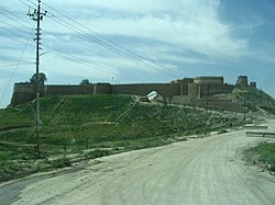
塔阿法
外觀
| 塔阿法 تلعفر 或 تل عفر Tal Afar或Tel Afer | |
|---|---|
 | |
| 坐標:36°22′45″N 42°26′59″E / 36.3792°N 42.4497°E | |
| 國 | |
| 省 | 尼尼微省 |
| 海拔 | 1,350 英尺(410 公尺) |
| 人口(2014年) | |
| • 總計 | 200,000[1]人 |

塔阿法(Tal Afar)是伊拉克的城市,位於該國北部,由尼尼微省負責管轄,處於首府摩蘇爾以西約60公里,鄰近與敘利亞接壤的邊境,2014年人口約20萬,其中四分之三居民信奉遜尼派。
伊斯蘭國於2014年攻佔塔阿法,直至2017年8月方為伊拉克政府收復。[2]
參考文獻
[編輯]- ^ ISIS control of Iraq spreads with major northern city capture. [2016-10-19]. (原始內容存檔於2016-01-12).
- ^ 伊拉克军收复泰勒阿费尔 攻破IS在伊最后主要据点. 中新網. 2017-08-28 [2017-08-28]. (原始內容存檔於2017-08-28).
外部連結
[編輯]- Iraq Image - Tal Afar Satellite Observation
- "Troops blitz Iraq's 'funnel of death'" (頁面存檔備份,存於網際網路檔案館) (The Daily Telegraph, Sept. 11, 2005)
- "Iraqis in former rebel stronghold now cheer American soldiers" (頁面存檔備份,存於網際網路檔案館) (The Daily Telegraph, Dec. 19, 2005)
- "Bomber attacks 'model Iraqi city'" (頁面存檔備份,存於網際網路檔案館) (BBC News, Oct. 7, 2006)
- TIME Magazine Photo Essay of Operation Restoring Rights (頁面存檔備份,存於網際網路檔案館)
- District map of Tal Afar (頁面存檔備份,存於網際網路檔案館)
- Tall 'Afar at Global Security (頁面存檔備份,存於網際網路檔案館)
| 這是一篇伊拉克地理小作品。您可以透過編輯或修訂擴充其內容。 |

