
File:Near east lrg.jpg

預覽大小:451 × 599 像素。 其他解析度:181 × 240 像素 | 361 × 480 像素 | 578 × 768 像素 | 771 × 1,024 像素 | 1,542 × 2,048 像素 | 2,987 × 3,967 像素。
原始檔案 (2,987 × 3,967 像素,檔案大小:2.62 MB,MIME 類型:image/jpeg)
| 描述 |
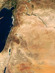
This true-color image of the region was taken on September 10, 2000, by the MODerate-resolution Imaging Spectroradiometer (MODIS) flying aboard NASA's Terra spacecraft. The image shows the lands of Israel along the eastern shore of the Mediterranean Sea, with the countries of Jordan to the southeast and Syria to the Northeast. The region known as the West Bank lies between the two countries. Running from north to south, the Jordan River links the Sea of Galilee to the Dead Sea. Click the image to enlarge it, and to see the borders drawn in. Image courtesy Jacques Descloitres, MODIS Land Group, NASA GSFC |
| 日期 | image taken on 10. Sep. 2000 |
| 來源 | http://earthobservatory.nasa.gov/Newsroom/NewImages/Images/modis_near_east_lrg.jpg |
| 作者 | NASA, earthobservatory, http://earthobservatory.nasa.gov/ |
| 授權許可 (重用此檔案) |
PD-USGov-NASA |
| 本作品由NASA創作,屬於公有領域。根據NASA的版權政策:“NASA的創作除非另有聲明否則不受版權保護。”(參見:Template:PD-USGov/zh,NASA版權政策或JPL圖像使用政策) | ||
 |
警告:
|
檔案歷史
點選日期/時間以檢視該時間的檔案版本。
| 日期/時間 | 縮圖 | 尺寸 | 使用者 | 備註 | |
|---|---|---|---|---|---|
| 目前 | 2015年2月5日 (四) 20:27 | | 2,987 × 3,967(2.62 MB) | Capricorn4049 | Cropped < 1 % horizontally and 1 % vertically using CropTool with precise mode. |
| 2005年6月5日 (日) 09:29 |  | 3,002 × 4,002(1.96 MB) | Prolineserver | near east, PD-USGov-NASA |
檔案用途
全域檔案使用狀況
以下其他 wiki 使用了這個檔案:
- ar.wikipedia.org 的使用狀況
- arz.wikipedia.org 的使用狀況
- ast.wikipedia.org 的使用狀況
- ba.wikipedia.org 的使用狀況
- ca.wikipedia.org 的使用狀況
- ckb.wikipedia.org 的使用狀況
- el.wikipedia.org 的使用狀況
- en.wikipedia.org 的使用狀況
- eo.wikipedia.org 的使用狀況
- eo.wikiquote.org 的使用狀況
- es.wikipedia.org 的使用狀況
- eu.wikipedia.org 的使用狀況
- fa.wikipedia.org 的使用狀況
- fr.wikipedia.org 的使用狀況
- gl.wikipedia.org 的使用狀況
- he.wikipedia.org 的使用狀況
- id.wikipedia.org 的使用狀況
- is.wikipedia.org 的使用狀況
- it.wikipedia.org 的使用狀況
- ja.wikipedia.org 的使用狀況
- kbp.wikipedia.org 的使用狀況
- ko.wikipedia.org 的使用狀況
檢視此檔案的更多全域使用狀況。