使用者:Addis-Bot/20140530/List of airports in Sierra Leone
外觀

This is a list of airports in Sierra Leone, sorted by location.
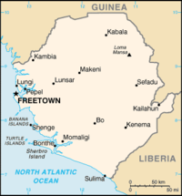
Sierra Leone, officially the Republic of Sierra Leone, is a country in West Africa. It is bordered by Guinea to the north, Liberia to the southeast, and the Atlantic Ocean to the southwest. Sierra Leone covers a total area of 71,740 km2(27,699 sq mi) and has a population estimated at 6.4 million. The country is a constitutional republic comprising three provinces and the Western Area, which are further divided into fourteen districts. The capital and largest city of Sierra Leone is Freetown.
Airports
[編輯]Names shown in bold indicate the airport has scheduled passenger service on commercial airlines.
| Location served | ICAO | IATA | Airport name |
|---|---|---|---|
| Bo | GFBO | KBS | Bo Airport |
| Sherbro, Bonthe | GFBN | BTE | Sherbro International Airport |
| Freetown | GFHA | HGS | Hastings Airport |
| Freetown | GFLL | FNA | Lungi International Airport |
| Gbangbatok | GFGK | GBK | Gbangbatok Airport |
| Kabala | GFKB | KBA | Kabala Airport |
| Kenema | GFKE | KEN | Kenema Airport |
| Yengema | GFYE | WYE | Yengema Airport |
See also
[編輯]- Transport in Sierra Leone
- List of airports by ICAO code: G#GF - Sierra Leone
- Wikipedia: WikiProject Aviation/Airline destination lists: Africa#Sierra Leone
References
[編輯]- ICAO Location Indicators by State (PDF). International Civil Aviation Organization. 2006-01-12.
- UN Location Codes: Sierra Leone. UN/LOCODE 2009-1. UNECE. 2009-09-23. - includes IATA codes
- Great Circle Mapper: Airports in Sierra Leone - IATA and ICAO codes, coordinates
