
File:Italy c 1810-es.png

本预览的尺寸:415 × 600像素。 其他分辨率:166 × 240像素 | 332 × 480像素 | 531 × 768像素 | 1,249 × 1,805像素。
原始文件 (1,249 × 1,805像素,文件大小:320 KB,MIME类型:image/png)
| 描述 |
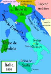
Political map of Italy in the years around 1810, during the Napoleonic era, created by MapMaster. This is a companion map to Image:Italy 1796.png and Image:Italy 1494_v2.png. Mapa político de Italia alrededor del año 1810, durante la era Napoleónica, creado por MapMaster (traducido por Aibdescalzo). Mapas relacionados: Image:Italy 1796.png y Image:Italy 1494_v2.png.
|
| 日期 | (UTC) |
| 来源 | |
| 作者 |
|
| 其他版本 |
[]
|


我,本作品著作权人,特此采用以下许可协议发表本作品:

|
已授权您依据自由软件基金会发行的无固定段落及封面封底文字(Invariant Sections, Front-Cover Texts, and Back-Cover Texts)的GNU自由文件许可协议1.2版或任意后续版本的条款,复制、传播和/或修改本文件。该协议的副本请见“GNU Free Documentation License”。 |
| 本文件采用知识共享署名-相同方式共享 3.0 未本地化版本许可协议授权。 | ||
| ||
| 本许可协议标签作为GFDL许可协议更新的组成部分被添加至本文件。 |
原始上传日志
This image is a derivative work of the following images:
- File:Italy_c_1810.png licensed with GFDL, GFDL/en
- 2006-10-19T04:01:10Z MapMaster 1251x1814 (394066 Bytes) Further improvements to bring it into line with [[:Image:Italy 1796.png]]
- 2006-10-13T12:41:34Z MapMaster 1251x1814 (412811 Bytes) Map was slightly improved.
- 2006-10-13T12:00:36Z MapMaster 1265x1816 (411395 Bytes) Political map of Italy in the years around 1810, during the Napoleonic era, created by MapMaster.
Uploaded with derivativeFX
文件历史
点击某个日期/时间查看对应时刻的文件。
| 日期/时间 | 缩略图 | 大小 | 用户 | 备注 | |
|---|---|---|---|---|---|
| 当前 | 2009年1月11日 (日) 01:15 | | 1,249 × 1,805(320 KB) | VanKleinen | {{Information |Description=Political map of Italy in the years around 1810, during the Napoleonic era, created by MapMaster. This is a companion map to Image:Italy 1796.png and Image:Italy 1494_v2.png. ---- Mapa político de Italia alrededor |
文件用途
没有页面链接到本图像。
全域文件用途
以下其他wiki使用此文件:
- es.wikipedia.org上的用途
- gl.wikipedia.org上的用途
- it.wikipedia.org上的用途