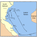
File:MaddoxTonkin1.svg
外观

此SVG文件的PNG预览的大小:608 × 599像素。 其他分辨率:244 × 240像素 | 487 × 480像素 | 779 × 768像素 | 1,039 × 1,024像素 | 2,078 × 2,048像素 | 685 × 675像素。
原始文件 (SVG文件,尺寸为685 × 675像素,文件大小:73 KB)
文件历史
点击某个日期/时间查看对应时刻的文件。
| 日期/时间 | 缩略图 | 大小 | 用户 | 备注 | |
|---|---|---|---|---|---|
| 当前 | 2007年10月15日 (一) 02:46 |  | 685 × 675(73 KB) | Interiot~commonswiki | fix tipo: "Golf"=>"Gulf" |
| 2007年10月15日 (一) 02:41 |  | 685 × 675(73 KB) | Interiot~commonswiki | delineate countries on the left better | |
| 2007年10月15日 (一) 02:22 |  | 685 × 675(57 KB) | Interiot~commonswiki | oops, add title back in | |
| 2007年10月15日 (一) 02:17 |  | 685 × 675(56 KB) | Interiot~commonswiki | make it clear that this is a river, and not a country boundary that splits Vietnam in half | |
| 2007年10月15日 (一) 02:07 |  | 685 × 675(56 KB) | Interiot~commonswiki | {{Information |Description=Chart showing the US Navy's interpretation of the events of the first part of the Gulf of Tonkin incident. |Source=http://www.history.navy.mil/photos/images/h96000/h96348.jpg |Date= |Author=Created by the U.S. Navy, and converte |
文件用途
以下3个页面使用本文件:
全域文件用途
以下其他wiki使用此文件:
- cs.wikipedia.org上的用途
- en.wikipedia.org上的用途
- es.wikipedia.org上的用途
- fi.wikipedia.org上的用途
- hu.wikipedia.org上的用途
- it.wikipedia.org上的用途
- ja.wikipedia.org上的用途
- ko.wikipedia.org上的用途
- pl.wikipedia.org上的用途
- pt.wikipedia.org上的用途
- ro.wikipedia.org上的用途
- sk.wikipedia.org上的用途
- uk.wikipedia.org上的用途
- vi.wikipedia.org上的用途


