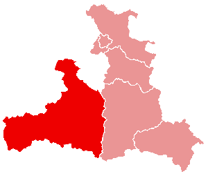
File:Salzburg Pinzgau.png
外观
Salzburg_Pinzgau.png (300 × 255像素,文件大小:2 KB,MIME类型:image/png)
文件历史
点击某个日期/时间查看对应时刻的文件。
| 日期/时间 | 缩略图 | 大小 | 用户 | 备注 | |
|---|---|---|---|---|---|
| 当前 | 2005年7月8日 (五) 22:55 |  | 300 × 255(2 KB) | Nikai | * Map of Salzburg (state), Pinzgau highlighted * Original by de:Benutzer:Butterbur, 6. März 2005 * compressed with pngcrush {{GFDL}} Category:Maps of Austria Category:Salzburg |
文件用途
以下页面使用本文件:
全域文件用途
以下其他wiki使用此文件:
- da.wikipedia.org上的用途
- de.wikipedia.org上的用途
- eo.wikipedia.org上的用途
- es.wikipedia.org上的用途
- fa.wikipedia.org上的用途
- fr.wikipedia.org上的用途
- Saalfelden
- Zell am See
- Saalbach-Hinterglemm
- District de Zell am See
- Kaprun
- Leogang
- Lofer (Autriche)
- Modèle:Palette District de Zell am See
- Krimml
- Rauris
- Bramberg am Wildkogel
- Hollersbach im Pinzgau
- Lend
- Maishofen
- Maria Alm
- Bruck an der Großglocknerstraße
- Dienten am Hochkönig
- Fusch an der Großglocknerstraße
- Mittersill
- Niedernsill
- Piesendorf
- St. Martin bei Lofer
- Stuhlfelden
- Neukirchen am Großvenediger
- Taxenbach
- Unken
- Uttendorf
- Viehhofen
- Wald im Pinzgau
- Weißbach bei Lofer
- Königsleiten
- fur.wikipedia.org上的用途
- hr.wikipedia.org上的用途
- ja.wikipedia.org上的用途
- nn.wikipedia.org上的用途
- no.wikipedia.org上的用途
- pl.wikipedia.org上的用途
- ru.wikipedia.org上的用途
- sh.wikipedia.org上的用途
- uz.wikipedia.org上的用途
- vi.wikipedia.org上的用途
- war.wikipedia.org上的用途


