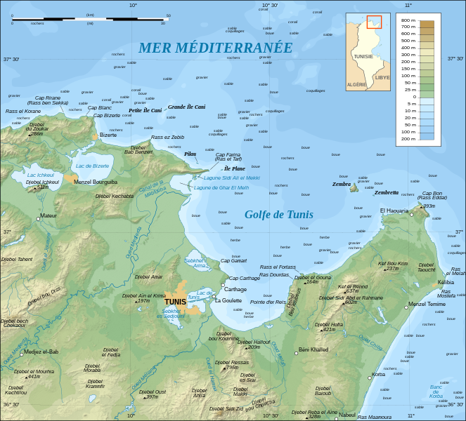
File:Tunis Gulf topo map-fr.svg
外观

此SVG文件的PNG预览的大小:663 × 600像素。 其他分辨率:265 × 240像素 | 531 × 480像素 | 849 × 768像素 | 1,132 × 1,024像素 | 2,264 × 2,048像素 | 1,990 × 1,800像素。
原始文件 (SVG文件,尺寸为1,990 × 1,800像素,文件大小:2.58 MB)
文件历史
点击某个日期/时间查看对应时刻的文件。
| 日期/时间 | 缩略图 | 大小 | 用户 | 备注 | |
|---|---|---|---|---|---|
| 当前 | 2008年9月1日 (一) 00:31 |  | 1,990 × 1,800(2.58 MB) | Sting | New standard colors |
| 2007年10月25日 (四) 22:16 |  | 1,990 × 1,800(2.57 MB) | Sting | Zembra / Zembretta islands correction ; + nature of the sea bottom indications | |
| 2007年10月25日 (四) 20:42 |  | 1,990 × 1,800(2.52 MB) | Sting | {{Information |Description=Topographic map in French of the Gulf of Tunis, Tunisia |Source=Own work ;<br/>Topographic map : [http://www2.jpl.nasa.gov/srtm NASA Shuttle Radar Topography Mission] (SRTM3 v.2) (public domain) edited with |
文件用途
以下页面使用本文件:
全域文件用途
以下其他wiki使用此文件:
- da.wikipedia.org上的用途
- de.wikipedia.org上的用途
- en.wikipedia.org上的用途
- es.wikipedia.org上的用途
- fr.wikipedia.org上的用途
- Province d'Afrique
- Utilisateur:Pline/création article
- Liste des golfes de Tunisie
- Golfe de Tunis
- Utilisateur:Urban/cartes
- Site archéologique de Carthage
- Utilisateur:Pradigue/Byrsa
- Église du prêtre Félix et baptistère de Kélibia
- Wikipédia:Atelier graphique/Cartes/Archives/Demandes mises en sommeil/Monde
- Discussion utilisateur:Sting/Archive 17
- Phare de Sidi Bou Saïd
- Phare de Zembretta
- Phare du Cap Bon
- fy.wikipedia.org上的用途
- he.wikipedia.org上的用途
- hr.wikipedia.org上的用途
- id.wikipedia.org上的用途
- ja.wikipedia.org上的用途
- ko.wikipedia.org上的用途
- lt.wikipedia.org上的用途
- mg.wikipedia.org上的用途
- nl.wikipedia.org上的用途
- no.wikipedia.org上的用途
- oc.wikipedia.org上的用途
- pl.wikipedia.org上的用途
- pl.wiktionary.org上的用途
- pt.wikipedia.org上的用途
- sl.wikipedia.org上的用途
- sv.wikipedia.org上的用途


