马哈达翁达:修订间差异
外观
删除的内容 添加的内容
小 机器人: 尚未清空的已重定向分类(CAT:马德里共同体市镇→CAT:马德里自治区市镇) |
翻译外文链接 内容扩充 |
||
| 第6行: | 第6行: | ||
| imagesize = |
| imagesize = |
||
| image_caption = |
| image_caption = |
||
| image_flag = |
| image_flag = Bandera_de_Majadahonda.png |
||
| flag_size = |
| flag_size = |
||
| image_shield = |
| image_shield = Escudo_de_Majadahonda.svg |
||
| shield_size = |
| shield_size = |
||
| pushpin_map = Spain |
| pushpin_map = Spain |
||
| pushpin_label_position = |
| pushpin_label_position = |
||
| pushpin_map_caption = 在西班牙的位置 |
| pushpin_map_caption = 在西班牙的位置 |
||
| |
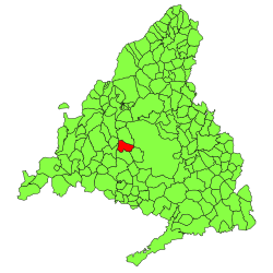
| image_map = Majadahonda_(Madrid)_mapa.svg |
||
| coordinates = {{coord|40|28|22|N|3|52|20|W|region:ES|display=inline}} |
|||
| longd = 3 |longm =52 |longs =20 |longEW = W |
|||
| coordinates_type = region:ES_type:city |
|||
| coordinates_display = inline,title |
|||
| subdivision_type = 国家 |
| subdivision_type = 国家 |
||
| subdivision_name = |
| subdivision_name = {{ESP}} |
||
| subdivision_type1 = [[西班牙行政区划|自治区]] |
| subdivision_type1 = [[西班牙行政区划|自治区]] |
||
| subdivision_name1 = [[马德里自治区]] |
| subdivision_name1 = {{Flagicon|Madrid}} [[马德里自治区]] |
||
| subdivision_type2 = [[省 (西班牙)|省]] |
| subdivision_type2 = [[省 (西班牙)|省]] |
||
| subdivision_name2 = 马德里省 |
| subdivision_name2 = 马德里省 |
||
| area_total_km2 = 39 |
| area_total_km2 = 39 |
||
| elevation_m = |
| elevation_m = |
||
| population_total = |
| population_total = 71299 |
||
| population_as_of = |
| population_as_of = 2017 |
||
| population_density_km2 = auto |
| population_density_km2 = auto |
||
| timezone1 = [[欧洲中部时间|CET]] |
| timezone1 = [[欧洲中部时间|CET]] |
||
| 第33行: | 第31行: | ||
| utc_offset1_DST = +2 |
| utc_offset1_DST = +2 |
||
| postal_code_type = 邮编 |
| postal_code_type = 邮编 |
||
| postal_code = |
| postal_code = 28220, 28221, 28222 |
||
| area_code_type = |
| area_code_type = |
||
| area_code = |
| area_code = |
||
| website = |
| website = {{Official website|http://www.majadahonda.org}} |
||
| footnotes = |
| footnotes = |
||
}} |
}} |
||
'''马哈达翁达'''( |
'''马哈达翁达'''({{lang-es|Majadahonda}};{{IPA-es|maxaðaˈonda}}),是[[西班牙]][[马德里自治区]]的一个[[市镇 (西班牙)|市镇]],距离[[马德里]]18公里。总面积39平方公里,总人口71,299人(2017年),人口密度1300人/平方公里。 |
||
==人口== |
|||
<center>{{Vertical bar chart|type=demography|width=635|color_13=blue|1900|822|1910|1067|1920|1094|1930|1233|1940|968|1950|1152|1960|2916|1970|5077|1981|22852|1991|33574|2001|50683|2011|70076|2017| 71299|note=<small> |
|||
来源:INE<ref>{{Cite web|url=http://www.ine.es/intercensal/intercensal.do?search=1&cmbTipoBusq=0&textoMunicipio=majadahonda&btnBuscarDenom=Consultar+selecci%F3n|title=Alteraciones de los municipios en los Censos de Población desde 1842 - Majadahonda|editor=Instituto Nacional de Estadística (España)|accessdate= 2012-12-04}}</ref><ref>{{cite web|url=http://www.ine.es/pob_xls/pobmun11.xls|title=Cifras oficiales de población resultantes de la revisión del Padrón municipal a 1 de enero de 2011|editor=Instituto Nacional de Estadística}}</ref>}} |
|||
</center> |
|||
==友好城市== |
|||
<center> |
|||
{| class="wikitable toc" cellpadding="0" cellspacing="2" width="720px" style="float:center; margin: 0.5em 0.5em 0.5em 1em; padding: 0.5e text-align:left;clear:all; margin-left:3px; font-size:90%" Green |
|||
|colspan=5 style="background:#black; color:white; font-size:120%" align=center bgcolor="black"|'''友好城市''' |
|||
|- bgcolor=silver |
|||
! <center> '''国家''' </center> |
|||
! <center> '''城市''' </center> |
|||
! <center> '''徽章''' </center> |
|||
! <center> '''图片''' </center> |
|||
|-bgcolor="#f0f0f0" |
|||
|align="left"| {{Flag|FRA}} |
|||
| <center>[[克拉马尔]]<ref name=femp>{{cite web|author=Federación Española de Municipios y Provincias|title=Listado de corporaciones locales españolas hermanadas con Europa|url=http://www.femp.es/files/566-1113-File/LISTADO%20HERMANAMIENTOS%20CON%20EUROPA.pdf|date=2013-01-01}}</ref></center> |
|||
| <center>[[File:Blason ville fr Clamart (Hauts-de-Seine).svg|45px|center]]</center> |
|||
| <center>[[File:Mairie de clamart.jpg|120px]]</center> |
|||
|- |
|||
|align="left"| {{Flag|HUN}} |
|||
| <center>[[弗朗茨城]]<ref name=femp /><br/>([[布达佩斯]])</center> |
|||
| <center>[[File:Coa Hungary Town Budapest 9th big.svg|80px]]</center> |
|||
| <center>[[File:Kálvin Tower and Budapest AEGON Center. - Kálvin Square, Budapešť 1252.jpg|120px]]</center> |
|||
|- |
|||
|}</center> |
|||
==参考文献== |
==参考文献== |
||
{{reflist}} |
{{reflist}} |
||
{{马德里大都市区}} |
|||
{{Authority control}} |
|||
[[Category:马德里自治区市镇]] |
[[Category:马德里自治区市镇]] |
||
2018年10月31日 (三) 13:06的版本
| 马哈达翁达 Majadahonda | |||
|---|---|---|---|
| 市镇 | |||
 | |||
| |||
 | |||
| 坐标:40°28′22″N 3°52′20″W / 40.47278°N 3.87222°W | |||
| 国家 | |||
| 自治区 | |||
| 省 | 马德里省 | ||
| 面积 | |||
| • 总计 | 39 平方公里(15 平方英里) | ||
| 人口(2017) | |||
| • 總計 | 71,299人 | ||
| • 密度 | 1,828人/平方公里(4,735人/平方英里) | ||
| 时区 | CET(UTC+1) | ||
| • 夏时制 | CEST(UTC+2) | ||
| 邮编 | 28220, 28221, 28222 | ||
| 網站 | 官方网站 | ||
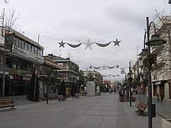
马哈达翁达(西班牙語:Majadahonda;西班牙語發音:[maxaðaˈonda]),是西班牙马德里自治区的一个市镇,距离马德里18公里。总面积39平方公里,总人口71,299人(2017年),人口密度1300人/平方公里。
人口
| 马哈达翁达 |
 |
友好城市
| 友好城市 | ||||
 | ||||
(布达佩斯) |
 |
 | ||
参考文献
- ^ Instituto Nacional de Estadística (España) (编). Alteraciones de los municipios en los Censos de Población desde 1842 - Majadahonda. [2012-12-04].
- ^ Instituto Nacional de Estadística (编). Cifras oficiales de población resultantes de la revisión del Padrón municipal a 1 de enero de 2011.
- ^ 3.0 3.1 Federación Española de Municipios y Provincias. Listado de corporaciones locales españolas hermanadas con Europa (PDF). 2013-01-01.
| ||||||||||||||||||||||||||||||||||
| |||||||||||||||||


