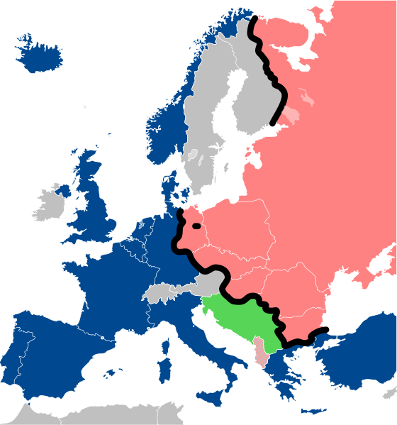
File:Iron Curtain map.svg
外观

此SVG文件的PNG预览的大小:560 × 599像素。 其他分辨率:224 × 240像素 | 449 × 480像素 | 718 × 768像素 | 957 × 1,024像素 | 1,914 × 2,048像素 | 645 × 690像素。
原始文件 (SVG文件,尺寸为645 × 690像素,文件大小:322 KB)
文件历史
点击某个日期/时间查看对应时刻的文件。
| 日期/时间 | 缩略图 | 大小 | 用户 | 备注 | |
|---|---|---|---|---|---|
| 当前 | 2022年12月15日 (四) 13:26 |  | 645 × 690(322 KB) | PhotographyEdits | Extend the Iron Curtain eastwards of Yugoslavia. Even though Yugoslavia was not really considered part of the West, the currenet map gives the false impression that there was a huge gap in the Iron Curtain, which wasn't the case. |
| 2022年7月23日 (六) 00:56 |  | 645 × 690(321 KB) | Kwamikagami | NATO blue, #004990 | |
| 2019年3月30日 (六) 20:30 |  | 645 × 690(321 KB) | Sémhur | Reverted to version as of 07:07, 27 May 2014 (UTC). Albania leaves the Waras Pack in middle of cold war; this is why it's shown wtih stripes. | |
| 2019年3月24日 (日) 09:18 |  | 512 × 548(123 KB) | Hakuli | Albania leaves the Waras Pack in middle of cold war | |
| 2014年5月27日 (二) 07:07 |  | 645 × 690(321 KB) | Sémhur | Valid SVG | |
| 2010年11月16日 (二) 13:51 |  | 645 × 690(321 KB) | Sémhur | Added Iron Curtain between Bulgaria and Greece & Turkey. | |
| 2008年9月27日 (六) 16:57 |  | 645 × 690(321 KB) | Sémhur | Correcting mistake : Austria wasn't in NATO. | |
| 2008年5月31日 (六) 10:51 |  | 645 × 690(330 KB) | Sémhur | {{Information |Description={{en|1=Map of the Iron Curtain in Europe.}} {{fr|1=Carte du rideau de fer en Europe.}} {{es|1=Mapa del Telón de Acero en Europa.}} |Source=Travail personnel (ow |
文件用途
全域文件用途
以下其他wiki使用此文件:
- af.wikipedia.org上的用途
- als.wikipedia.org上的用途
- ar.wikipedia.org上的用途
- ast.wikipedia.org上的用途
- azb.wikipedia.org上的用途
- az.wikipedia.org上的用途
- ba.wikipedia.org上的用途
- be-tarask.wikipedia.org上的用途
- be.wikipedia.org上的用途
- bg.wikipedia.org上的用途
- br.wikipedia.org上的用途
- bs.wikipedia.org上的用途
- ca.wikipedia.org上的用途
- cs.wikipedia.org上的用途
- cy.wikipedia.org上的用途
- da.wikipedia.org上的用途
- de.wikipedia.org上的用途
- el.wikipedia.org上的用途
- el.wiktionary.org上的用途
- en.wikipedia.org上的用途
查看此文件的更多全域用途。

