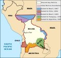
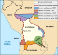
File:Map Bolivia territorial loss-en.svg
外观

此SVG文件的PNG预览的大小:375 × 355像素。 其他分辨率:254 × 240像素 | 507 × 480像素 | 811 × 768像素 | 1,082 × 1,024像素 | 2,163 × 2,048像素。
原始文件 (SVG文件,尺寸为375 × 355像素,文件大小:78 KB)
文件历史
点击某个日期/时间查看对应时刻的文件。
| 日期/时间 | 缩略图 | 大小 | 用户 | 备注 | |
|---|---|---|---|---|---|
| 当前 | 2020年1月1日 (三) 16:19 |  | 375 × 355(78 KB) | Janitoalevic | Added territory ceded to Argentina |
| 2013年12月12日 (四) 18:48 |  | 375 × 355(68 KB) | Pethrus | Fixed ocean name | |
| 2010年5月4日 (二) 16:07 |  | 375 × 355(68 KB) | Naturals | The territory of Paraguay was reversed with the territory of Brazil | |
| 2010年5月3日 (一) 19:06 |  | 375 × 355(69 KB) | Pethrus | Paraguay border fixed | |
| 2010年5月3日 (一) 19:02 |  | 375 × 355(69 KB) | Pethrus | Fixed bugs | |
| 2010年5月3日 (一) 18:56 |  | 375 × 355(79 KB) | Pethrus | Inkscape bugs fixed | |
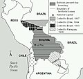
| 2010年5月3日 (一) 18:53 |  | 375 × 355(81 KB) | Pethrus | {{Information |Description={{en|Territorial loss map of Bolivia}} |Source=*File:Bolivia_territorial_loss_map_LOC.jpg |Date=2010-05-03 18:51 (UTC) |Author=*File:Bolivia_territorial_loss_map_LOC.jpg: Library of Congress Country Study on Bolivia |
文件用途
以下页面使用本文件:
全域文件用途
以下其他wiki使用此文件:
- az.wikipedia.org上的用途
- ca.wikipedia.org上的用途
- cs.wikipedia.org上的用途
- da.wikipedia.org上的用途
- de.wikipedia.org上的用途
- en.wikipedia.org上的用途
- eu.wikipedia.org上的用途
- fi.wikipedia.org上的用途
- fr.wikipedia.org上的用途
- hi.wikipedia.org上的用途
- hi.wiktionary.org上的用途
- id.wikipedia.org上的用途
- it.wikipedia.org上的用途
- ja.wikipedia.org上的用途
- ka.wikipedia.org上的用途
- ko.wikipedia.org上的用途
- lt.wikipedia.org上的用途
- nl.wikipedia.org上的用途
- pl.wikipedia.org上的用途
- pt.wikipedia.org上的用途
- sat.wikipedia.org上的用途
- sd.wikipedia.org上的用途
- sk.wikipedia.org上的用途
- te.wikipedia.org上的用途


