跳转到内容

File:Aleutians-space.jpg

页面内容不支持其他语言。
这个文件来自维基共享资源
维基百科,自由的百科全书

原始文件 (3,904 × 3,904像素,文件大小:10.69 MB,MIME类型:image/jpeg


摘要

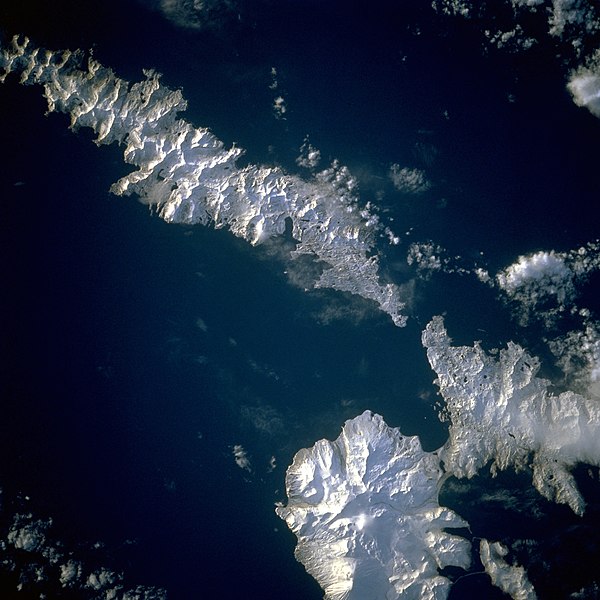
描述 Aleutian Islands from space A photograph of Atka Island, Amlia Island, and other parts of the Aleutian chain, Alaska. Taken on the STS-56 shuttle mission, in April 1993. Image number: STS056-071-031 The oval, snow-covered northern peninsula of Atka Island, a cluster of severely eroded stratovolcanoes and caldera, is part of the Aleutian chain known as the Central Aleutian Islands. Korovin Volcano, near the northern edge of the island, has the highest elevation on the island [5030 feet (1533 meters)] and the most eruptive activity. Elongated, east-west-oriented Amlia Island to the east rises only 2100 feet (640 meters) at its highest elevation.
日期
来源 http://eol.jsc.nasa.gov/sseop/EFS/lores.pl?PHOTO=STS056-71-31
作者 NASA
相机位置52° 50′ 00″ 北, 173° 50′ 00″ 西 Kartographer map based on OpenStreetMap.在以下服务上查看本图像和附近其他图像: OpenStreetMapinfo
本图像或视频收录于美国国家航空航天局 (NASA)某个部门,其照片编号是: STS056-71-31

此标签不表示文件的著作权状态。任何文件在附有此标签的同時还需要一个有效的著作权标签请参阅许可协议说明页面以了解更多信息。
其他语言:

许可协议

Public domain 本文件完全由NASA创作,在美国属于公有领域。根据NASA的版权方针,NASA的材料除非另有声明否则不受版权保护。(参见Template:PD-USGov/zhNASA版权方针页面JPL图片使用方针。)
警告:

说明

添加一行文字以描述该文件所表现的内容

此文件中描述的项目

描绘内容

STS-56 中文(已转写)

52°49'59.999"N, 173°49'59.999"W

image/jpeg

55d9228dfde9af5540c6a32cd45110f94cd1a942

11,211,469 字节

3,904 像素

3,904 像素

文件历史

点击某个日期/时间查看对应时刻的文件。

日期/时间缩⁠略⁠图大小用户备注
当前2010年8月26日 (四) 14:432010年8月26日 (四) 14:43版本的缩略图3,904 × 3,904(10.69 MB)Originalwanahigher res
2004年12月4日 (六) 22:522004年12月4日 (六) 22:52版本的缩略图639 × 639(307 KB)MschlindweinAleutian Islands from space

以下页面使用本文件:

全域文件用途

以下其他wiki使用此文件:

元数据