蒙哥馬利郡
外觀
| Montgomeryshire 威爾斯語:Sir Drefaldwyn | |
|---|---|
 | |
 Ancient extent of Montgomeryshire | |
| 坐標:52°35′00″N 3°30′00″W / 52.5833°N 3.5°W | |
| 面積 | |
| • 1831 | 483,323英畝(1,955.94平方公里) |
| • 2011 | 537,000英畝(2,170平方公里) |
| 人口 | |
| • 1831 | 66,482[1] |
| • 2011 | 63,779 |
| 密度 | |
| • 1831 | 0.1/acre |
| 歷史 | |
| • 繼任 | 波伊斯 |
| Chapman code | MGY |
| 政府 | Montgomeryshire County Council (1889–1974) Montgomeryshire District Council (1974–1996) |
| • 行政中心 | Montgomery |
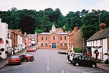
蒙哥馬利郡(威爾斯語:Montgomeryshire,威爾斯語:Sir Drefaldwyn)是威爾斯的13個歷史上的郡之一,郡名來自於郡治蒙哥馬利。現在蒙哥馬利郡是波伊斯的北部地區。據2011年英國人口普查,蒙哥馬利郡有人口63,779人[2],人口密度每平方公里只有29人。
