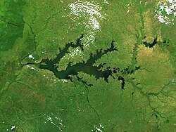
基奧加湖
外觀
| 基奧加湖 | |
|---|---|
 2002年衛星影像 | |
| 座標 | 1°30′N 33°0′E / 1.500°N 33.000°E |
| 集水面積 | 75,000平方公里 |
| 所在國家 | 烏干達 |
| 最大長度 | 約200公里 |
| 表面積 | 1,720平方公里 |
| 最大深度 | 5.7米 |
| 表面海拔 | 914米 |
| 位置 | |
 | |
基奧加湖(英語:Lake Kyoga)是烏干達中部的大型淡水湖,面積1,720平方公里,海拔914米,屬於大湖地區的水體系統。基奧加湖大部分區域的水深大於4米,最大深度約5.7米,水深少於3米的地區長滿睡蓮,紙莎草和鳳眼藍則在沼澤狀的湖邊生長,湖中有46種魚類和少數鱷魚。1997至1998年的厄爾尼諾現象帶來的大量雨水使水位急升,紙莎草和鳳眼藍堵塞湖泊的出口處,湖水氾濫面積580平方公里,2004年埃及政府向烏干達援助13億美元以控制水流。
參考文獻
[編輯]- DWD (2002) El Niño preparedness for Lake Kyoga and other flood prone areas of Uganda. Directorate of Water Development. Ministry of Water, Lands and Environment, Entebbe, Uganda.
- ILM (2004) Support to the Management of Sudd Blockage on Lake Kyoga. Produced for the Integrated Lake Management Project by Environmental Impact Assessment Centre of Finland, EIA Ltd. (online PDF version)
- Twongo, T. (2001) The Fisheries and environment of Kyoga Lakes. Fisheries Resources Research Institute (FIRRI), Jinja, Uganda.
- World Lake Database entry for Lake Kyoga
外部連結
[編輯]- Lakes and rivers in Uganda (頁面存檔備份,存於互聯網檔案館)
- Lake Kyoga (World Lakes Database)
- Modelling Lake Kyoga (Environmental Impact Assessment Centre, Finland)
