格蘭德美爾州立公園
外觀
| 格蘭德美爾州立公園 | |
|---|---|
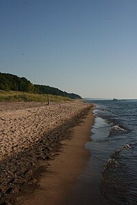
 格蘭德美爾州立公園的一個沙灘 | |
| 位置 | 林肯鎮區 貝林縣 |
| 最近城鎮 | 史蒂芬斯維爾縣 |
| 座標 | 42°00′30″N 86°32′20″W / 42.00833°N 86.53889°WGrand Mere State Park. Geographic Names Information System. United States Geological Survey. |
| 面積 | 985英畝(399公頃) |
| 海拔 | 587英尺(179米) [2] |
| 指定 | 密歇根州立公園 |
| 建立 | 1973[3] |
| 管理者 | 密歇根州自然資源部 |
| 網站 | Grand Mere State Park |
| 評定時間 | 1968 |
格蘭德美爾州立公園 (Grand Mere State Park)是一個位於美國密歇根州史蒂芬斯維爾縣的自然保護及公眾娛樂區。州立公園位於94號州際公路旁,公園西邊的沙丘保護着密歇根湖,令公園具有許多州內其他地方尚未發現的自然景觀[4]。1968年被美國政府指定為美國國家自然地標[5]。
地理
[編輯]格蘭德美爾州立公園佔地985-英畝(3.99-平方公里),大部份佔地被林植覆蓋。原本園內有五個由冰河時期冰層溶化後而成的內陸湖[6],現時因自然流失,只剩三個[7] 。公園的沙丘更創造了一個相對涼爽的環境,令在密歇根州南部不常見的植物得以生存,當中有些植物被歸類為「稀有」或「瀕危」[6]。
活動及設施
[編輯]格蘭德美爾州立公園提供游泳、登山、野餐、船舶下水裝置及越野滑雪設施[4]。公園兩英里外有一個沙灘,徒步走過沙丘便可到達。園內更有多個供登山及越野滑雪用的小徑,但大部份均無人保養或駐守[6],小徑禁止踏單車。小徑地質由散沙至壓土不等。園內有多座山,包括一個曾開放給越野車的大沙丘。但現時沙丘已有欄杆阻隔,大型四輪車已被禁止入內。
參考來源
[編輯]- ^ Grand Mere State Park. Protected Planet. IUCN. [March 27, 2020]. (原始內容存檔於2018-02-19).
- ^ Grand Mere State Park. Geographic Names Information System. United States Geological Survey.
- ^ 3.0 3.1 When were Michigan state parks and recreation areas established? (PDF). Michigan Department of Natural Resources. [March 27, 2020]. (原始內容存檔 (PDF)於2019-04-19).
- ^ 4.0 4.1 4.2 Grand Mere State Park. Michigan Department of Natural Resources. [February 18, 2018]. (原始內容存檔於2019-11-03).
- ^ 5.0 5.1 Grand Mere Lakes. National Natural Landmarks. National Park Service. [February 18, 2018]. (原始內容存檔於2019-07-13).
- ^ 6.0 6.1 6.2 6.3 DuFresne, Jim (2005). The Complete Guide to Michigan Sand Dunes, pp. 30-32. The University of Michigan Press.047203118X
- ^ 7.0 7.1 Grand Mere. Natural Areas. Michigan Department of Natural Resources. [March 27, 2020]. (原始內容存檔於2020-07-20).
外部連結
[編輯]- 格蘭德美爾州立公園網頁 (頁面存檔備份,存於互聯網檔案館)
- 格蘭德美爾州立公園地圖 (頁面存檔備份,存於互聯網檔案館)

