
都特羅尼勒斯桌山群
| 都特羅尼勒斯桌山群 | |
|---|---|
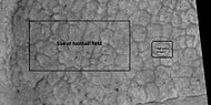
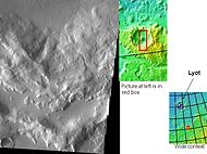
 地圖顯示了普羅敦尼勒斯和都特羅尼勒斯桌山群與鄰近地區的關係,顏色表示高度。 | |
| 坐標 | 43°54′N 337°24′W / 43.9°N 337.4°W座標:43°54′N 337°24′W / 43.9°N 337.4°W |
都特羅尼勒斯桌山群(Deuteronilus Mensae)是火星上一處方圓937公里的區域,其中心坐標為北緯43.9°、西經337.4°處,它東西橫跨西經344°–西經325°,南北覆蓋北緯40°–北緯48°[1]。都特羅尼勒斯桌山群區坐落於阿拉伯台地北部,並被包含在伊斯墨諾斯湖區內。它緊鄰火星南北分界線,處於古老崎嶇的南部高地和北半球低地平原之間。該地區分佈着眾多可能形成於過去某個冰川期的平頂瘤狀地形,東面則是普羅敦尼勒斯桌山群和伊斯墨諾斯槽溝群[2][3]。目前該地區依然存有冰川,據估計至少有一道冰川形成於最近1萬至10萬年前[4],從最近火星勘測軌道飛行器的淺層雷達探測表明,都特羅尼勒斯桌山群部分地區確實蘊藏着水冰[5][6][7]。
都特羅尼勒斯桌山群取名自古典返照率特徵,「都特羅尼勒斯」(Deuteronilus)一詞為拉丁語尼羅河(Nilus)的第二部分的意思。
冰源[編輯]
現在普遍認為,火星上包括都特羅尼勒斯桌山群在內的許多地方都聚積有水冰,當時該行星的軌道傾角與現在大不相同(火星的軸線有相當大幅度的「擺動」,這意味着它的角度會隨着時間而變化)[8][9][10]。幾百萬年前,火星自轉軸的傾角為45度,而非現在的25度。它的傾斜度變化很大,因為它的兩顆小衛星無法像能穩住地球的月球那樣來穩住它。
火星上的許多特徵,包括都特羅尼勒斯桌山群,被認為都含有大量的水冰。有關冰起源最流行的模型是行星自轉軸傾斜度的巨大變化所引起的氣候改變,有時傾斜度甚至超過80度[11][12],傾斜度的巨大變化解釋了火星上許多富冰的地貌特徵。
研究顯示,當火星傾角從目前的25度上升到45度時,兩極的冰就不再穩定[13]。此外,在這種高傾角下,儲存的固體二氧化碳(乾冰)升華,從而增加了大氣壓,而大氣壓的增加又會使更多塵埃滯留在大氣層中,大氣中的水分將以雪或冰的形式附着在塵埃顆粒上。計算表明,這種物質主要集中在中緯度地區[14][15]。
火星大氣層環流模型預測了富冰塵埃聚集於發現富冰特徵的相同區域[16]。當傾斜度開始回復到較低水平時,冰升華(直接轉化為氣體)並留下一層塵埃[17][18]。滯後的沉積層覆蓋了下面的地層,因此在每一輪高傾角循環中,一些富冰層仍被留在下面 [19]。注意,平坦的覆蓋層可能只代表相對較近的地層。
多邊形圖案地[編輯]
在火星某些地區,多邊形圖案地表(Polygonal patterned ground)很常見[20][21][22][23][24][25][26],其原因認為是地面上冰升華所引起。升華是固體冰的直接氣化,類似於地球上乾冰的情況。火星上呈現多邊形地面的地方可能表明未來定居者可在那裏找到水冰。圖案地面形成於在不同氣候,從天空飄落的覆蓋層(稱為緯度相關覆蓋層)[27][28][29][30]。
-
 HiWish計劃下高解像度成像科學設備所看到的高中心多邊形為都特羅尼勒斯桌山群的碎屑圍裙頂部。
 -
 HiWish計劃下高解像度成像科學設備顯示的帶縮放比的高中心多邊形區高空視場特寫。註:黑框區面積與足球場相同
 -
 HiWish計劃下高解像度成像科學設備顯示的高中心多邊形區特寫。註:黑框區面積與足球場相同。
 -
 HiWish計劃下高解像度成像科學設備顯示的高中心多邊形特寫,可清楚地看見多邊形之間的凹槽。
 -
 HiWish計劃下高解像度成像科學設備顯示的高中心多邊形區。


上部平原單元[編輯]
在火星中緯度區發現了一處50-100米厚的殘餘覆蓋層,稱為上部平原單元,首次是在都特羅尼勒斯桌山群區探測到,但其他地方也有出現。該殘餘層由隕石坑和台地上的一系列傾斜層組成[31],這些傾斜層可能有各種大小和形狀,有些看起來像中美洲阿茲特克金字塔。
-
 按照 HiWish 計劃下高解像度成像科學設備顯示的一組小的傾斜層。

這種單元也會退化為腦紋地形,腦紋地形是一種3-5米高的迷宮狀楞脊區。有些山脊可能由冰核構成,因此它們又可能成為未來定居者的水源。
-
 分層特徵和腦紋地形,如 HiWish 計劃下高解像度成像科學設備所顯示,上層平原單元經常會轉變為腦紋地形。

上部平原單元的一些區域顯示出大型裂縫和帶凸起邊緣的凹槽,這些地區被稱為肋狀上層平原(ribbed upper plains)。據信斷裂起始於應力引起的小裂縫,因為當碎屑堆聚集在一起或靠近碎屑堆邊緣時,在此類地點就會產生擠壓應力,這在肋狀上層平原很常見,應力則引發斷裂過程。裂縫暴露了更多的地表,因此地層中更多的冰升華到行星稀薄的大氣層中。最終,小裂縫變成為大峽谷或大槽溝。
-
 發育良好的肋狀上平原地層,它們起始於小裂縫,隨着冰從表面裂縫中升華而擴展。該照片為HiWish 項目指示高解像度成像科學設備拍攝。
 -
 HiWish 計劃也使用高解像度成像科學設備顯示了傾斜層,在圖片右上角可看到肋狀上平原地層,它形成於上部平原單元,反過來又會被侵蝕成腦紋地形。
 -
 應力縫和因升華(冰直接氣化)而擴大的較大裂縫圖,這可能是肋狀地形的開始。
 -
 如HiWish計劃下高解像度成像科學設備所示,應力紋引起的肋狀地形演變-左側的裂縫最終會擴大演變成圖片右側的肋狀地形。
 -
 科羅拉多州紅岩公園的層狀特徵。它的起源與火星上的不同,但形狀類似。紅岩區的地質特徵是由山脈隆起所引起。


小裂縫通常包含小洞坑和洞坑鏈,被認為產生於地表冰的升華[32][33]。 火星表面大部分區域都蘊含了水冰,冰被一層1米厚的塵埃和其他物質所保護。然而,一旦出現地表縫,將會使水冰暴露在稀薄的大氣層中[34][35],在很短時間內,冰將消失在寒冷稀薄的大氣中,這一過程稱為升華,乾冰在地球上也有類似的行為。當鳳凰號火星探測器發現裸露的冰塊在幾天內就消失時,則察覺到了火星上的升華現象[36][37]。此外,高解像度成像科學設備還發現了坑底有冰的新隕坑,但隔了一段時間後,它看到的冰沉積物就已消失無蹤了[38]。
-
![在四天的時間裏,被挖開的「渡渡鳥-金鳳花」溝中模具大小的白色物質消失了,這意味着它們是由冰組成的,冰在暴露後就會升華[37]。](//upload.wikimedia.org/wikipedia/commons/thumb/1/1d/Ice_sublimating_in_the_Dodo-Goldilocks_trench.gif/75px-Ice_sublimating_in_the_Dodo-Goldilocks_trench.gif)
-
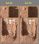 彩色照片顯示了冰的升華,圖片右上角插圖為放大了的挖溝左下角。
![在四天的時間裏,被挖開的「渡渡鳥-金鳳花」溝中模具大小的白色物質消失了,這意味着它們是由冰組成的,冰在暴露後就會升華[37]。](/wiki/File:Ice_sublimating_in_the_Dodo-Goldilocks_trench.gif)

據認為,上部平原單元來自於天空降落的物質,它覆蓋在各種表面上,好似均勻飄落。與其他覆蓋沉積物一樣,上層平原單元具有層狀、細粒度和富含冰,它分佈普遍,似乎沒有來源點。火星某些區域的表面外觀是由於該單元的退化造成的,它也是造成舌狀岩屑坡表面外觀的主要原因[33]。據信,上部平原覆蓋層單元和其他覆蓋層單元的分層是由該行星氣候的重大變化所導致。模型預測,隨着地質時間推移,火星自轉軸傾角或傾斜度可能會從目前的25度改變到超過80度。高傾斜期間將導致火星極地冰蓋中的冰重新分佈,並改變大氣層中的塵埃含量[39][40][41]。
其它圖片[編輯]
-
 2005 年 3 月 14 日拍攝的都特羅尼勒斯桌山群照片。
 -
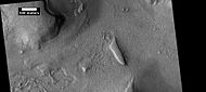
 火星全球探勘者號顯示的都特羅尼勒斯桌山群。
 -
 熱輻射成像系統顯示,都特羅尼勒斯桌山群山脊反映了沉積物的移動。
 -
 熱輻射成像系統顯示的都特羅尼勒斯桌山群中一座隕坑壁中的小山谷。


-

-
 左邊照片中顯示懸崖部分的放大。由火星全球探勘者號(MGS)上高解像度照相機拍攝。
 -
 背景相機拍攝的都特羅尼勒斯桌山群照片,顯示了下二幅照片的位置。
 -
 HiWish計劃下高解像度成像科學設備顯示的都特羅尼勒斯桌山群中的侵蝕地形。
 -
 HiWish計劃下高解像度成像科學設備顯示的另一幅都特羅尼勒斯桌山群侵蝕地形照片。
 -
 背景相機照片顯示了下二幅高解像度成像科學設備拍攝的圖像位置,位於伊斯墨諾斯湖區。
 -
 HiWish計劃下高解像度成像科學設備觀察到的都特羅尼勒斯桌山群中,一座可能是過去冰川末端冰磧的土丘。該圖像的位置是前一圖像中所標註的A框。
 -
 HiWish計劃下高解像度成像科學設備觀察到的都特羅尼勒斯桌山群中,環土丘周邊的複雜表面。該圖像的位置位於上面背景相機照片中標註的B框內。
 -
 高解像度成像科學設備顯示的都特羅尼勒斯桌山群中被掏空的地形。
 -
 高解像度成像科學設備顯示的大群同心裂紋。


另請參閱[編輯]
參考文獻[編輯]
- ^ Patrick Moore; Garry Hunt. The atlas of the solar system. Chancellor. 1997. ISBN 978-0-7537-0014-3.
- ^ Baker, M. et al. 2010. Flow patterns of lobate debris aprons and lineated valley fill north of Ismeniae Fossae, Mars: Evidence for extensive mid-latitude glaciation in the Late Amazonian. Icarus: 207. 186–209.
- ^ 存档副本. [2021-07-31]. (原始內容存檔於2012-10-18).
- ^ Rincon, Paul. 'Active glacier found' on Mars. BBC News. 19 December 2007 [2021-07-31]. (原始內容存檔於2007-12-23).
- ^ 存档副本. [2021-07-31]. (原始內容存檔於2021-03-09).
- ^ http://news.discovery.com/space/mars-ice-sheet-climate.html
- ^ Plaut, J., A. Safaeinili,, J. Holt, R. Phillips, J. Head, J., R. Seu, N. Putzig, A. Frigeri. 2009. Radar evidence for ice in lobate debris aprons in the midnorthern latitudes of Mars. Geophys. Res. Lett. 36. doi:10.1029/2008GL036379.
- ^ Madeleine, J. et al. 2007. Mars: A proposed climatic scenario for northern mid-latitude glaciation. Lunar Planet. Sci. 38. Abstract 1778.
- ^ Madeleine, J. et al. 2009. Amazonian northern mid-latitude glaciation on Mars: A proposed climate scenario. Icarus: 203. 300–405.
- ^ Mischna, M. et al. 2003. On the orbital forcing of martian water and CO2 cycles: A general circulation model study with simplified volatile schemes. J. Geophys. Res. 108. (E6). 5062.
- ^ Touma J. and J. Wisdom. 1993. The Chaotic Obliquity of Mars. Science 259, 1294–1297.
- ^ Laskar, J., A. Correia, M. Gastineau, F. Joutel, B. Levrard, and P. Robutel. 2004. Long term evolution and chaotic diffusion of the insolation quantities of Mars. Icarus 170, 343–364.
- ^ Levy, J., J. Head, D. Marchant, D. Kowalewski. 2008. Identification of sublimation-type thermal contraction crack polygons at the proposed NASA Phoenix landing site: Implications for substrate properties and climate-driven morphological evolution. Geophys. Res. Lett. 35. doi:10.1029/2007GL032813.
- ^ Levy, J., J. Head, D. Marchant. 2009a. Thermal contraction crack polygons on Mars: Classification, distribution, and climate implications from HiRISE observations. J. Geophys. Res. 114. doi:10.1029/2008JE003273.
- ^ Hauber, E., D. Reiss, M. Ulrich, F. Preusker, F. Trauthan, M. Zanetti, H. Hiesinger, R. Jaumann, L. Johansson, A. Johnsson, S. Van Gaselt, M. Olvmo. 2011. Landscape evolution in Martian mid-latitude regions: insights from analogous periglacial landforms in Svalbard. In: Balme, M., A. Bargery, C. Gallagher, S. Guta (eds). Martian Geomorphology. Geological Society, London. Special Publications: 356. 111–131
- ^ Laskar, J., A. Correia, M. Gastineau, F. Joutel, B. Levrard, and P. Robutel. 2004.Long term evolution and chaotic diffusion of the insolation quantities of Mars. Icarus 170, 343–364.
- ^ Mellon, M., B. Jakosky. 1995. The distribution and behavior of Martian ground ice during past and present epochs. J. Geophys. Res. 100, 11781–11799.
- ^ Schorghofer, N., 2007. Dynamics of ice ages on Mars. Nature 449, 192–194.
- ^ Madeleine, J., F. Forget, J. Head, B. Levrard, F. Montmessin. 2007. Exploring the northern mid-latitude glaciation with a general circulation model. In: Seventh International Conference on Mars. Abstract 3096.
- ^ 存档副本 (PDF). [2021-07-31]. (原始內容存檔 (PDF)於2017-08-14).
- ^ Kostama, V.-P., M. Kreslavsky, Head, J. 2006. Recent high-latitude icy mantle in the northern plains of Mars: Characteristics and ages of emplacement. Geophys. Res. Lett. 33 (L11201). doi:10.1029/2006GL025946. K>
- ^ Malin, M., Edgett, K. 2001. Mars Global Surveyor Mars Orbiter Camera: Interplanetary cruise through primary mission. J. Geophys. Res. 106 (E10), 23429–23540.
- ^ Milliken, R., et al. 2003. Viscous flow features on the surface of Mars: Observations from high-resolution Mars Orbiter Camera (MOC) images. J. Geophys. Res. 108 (E6). doi:10.1029/2002JE002005.
- ^ Mangold, N. 2005. High latitude patterned grounds on Mars: Classification, distribution and climatic control. Icarus 174, 336–359.
- ^ Kreslavsky, M., Head, J. 2000. Kilometer-scale roughness on Mars: Results from MOLA data analysis. J. Geophys. Res. 105 (E11), 26695–26712.
- ^ Seibert, N., J. Kargel. 2001. Small-scale martian polygonal terrain: Implications for liquid surface water. Geophys. Res. Lett. 28 (5), 899–902. S
- ^ Hecht, M. 2002. Metastability of water on Mars. Icarus 156, 373–386
- ^ Mustard, J., et al. 2001. Evidence for recent climate change on Mars from the identification of youthful near-surface ground ice. Nature 412 (6845), 411–414.
- ^ Kreslavsky, M.A., Head, J.W., 2002. High-latitude Recent Surface Mantle on Mars: New Results from MOLA and MOC. European Geophysical Society XXVII, Nice.
- ^ Head, J.W., Mustard, J.F., Kreslavsky, M.A., Milliken, R.E., Marchant, D.R., 2003. Recent ice ages on Mars. Nature 426 (6968), 797–802.
- ^ Carr, M. 2001. Mars Global Surveyor observations of martian fretted terrain. J. Geophys. Res. 106, 23571-23593.
- ^ Morgenstern, A., et al. 2007
- ^ 33.0 33.1 Baker, D., J. Head. 2015. Extensive Middle Amazonian mantling of debris aprons and plains in Deuteronilus Mensae, Mars: Implication for the record of mid-latitude glaciation. Icarus: 260, 269–288.
- ^ Mangold, N. 2003. Geomorphic analysis of lobate debris aprons on Mars at Mars Orbiter Camera scale: Evidence for ice sublimation initiated by fractures. J. Geophys. Res. 108, 8021.
- ^ Levy, J. et al. 2009. Concentric
- ^ Bright Chunks at Phoenix Lander's Mars Site Must Have Been Ice (頁面存檔備份,存於互聯網檔案館) – Official NASA press release (19.06.2008)
- ^ 37.0 37.1 存档副本. [2021-07-31]. (原始內容存檔於2016-03-04).
- ^ Byrne, S. et al. 2009. Distribution of Mid-Latitude Ground Ice on Mars from New Impact Craters: 329.1674–1676
- ^ Head, J. et al. 2003.
- ^ Madeleine, et al. 2014.
- ^ Schon, et al. 2009. A recent ice age on Mars: Evidence for climate oscillations from regional layering in mid-latitude mantling deposits. Geophys. Res. Lett. 36, L15202.
| 維基共享資源上的相關多媒體資源:都特羅尼勒斯桌山群 |
外部連結[編輯]
- Views of Deuteronilus Mensae on Mars (頁面存檔備份,存於互聯網檔案館) from Mars Express
- Scarps in Deuteronilus Mensae (頁面存檔備份,存於互聯網檔案館) from HiRISE
- Jeffrey Plaut – Subsurface Ice – 21st Annual International Mars Society Convention (頁面存檔備份,存於互聯網檔案館)
| ||||||||||||||||||||||||||||||||||||||||||||||||||||||||||||||||||||||||||||||||||||||||