
用戶:DDRVIII/新南威爾斯州凱亞馬
凱亞馬是伊拉瓦拉地區的一座海濱城市,位於悉尼南方120公里。凱亞馬噴水洞是此地吸引遊客的主要原因之一。凱亞馬所擁有的若干衝浪海灘和房車公園,以及數個露天咖啡廳和餐館,很受歡迎。靠近悉尼南部使得它吸引了大量單日游和短期遊客人。
歷史[編輯]

Kiama was the site of two strong volcanic flows, called the Gerringong Volcanics, which came out of馬鞍山 Saddleback Mountain, now a collapsed volcanic vent. The Kiama Blowhole is part of an erosion process on the more recent rock, formed into columnar basalt, or latite. Before the cedar-getters (comprising ex-convicts, convicts and runaways, some with cedar licences and many without) arrived in the area around 1810, the local Indigenous Australians, Wodi Wodi of the language group Dharawal, had been using the land for thousands of years, moving every six weeks or so in family groups. This is supported by a midden of shells at nearby Bass Point used for more than 17,000 years. During this time the whole coastal hills was covered in rainforest and cedar brush. There is evidence of a flourishing culture with intricate possum cloaks, a developed song and story cycle, and a deep understanding of the many plants of the rainforest. Only a few remnants of rainforest survive along the escarpment in places like the Minnamurra Rainforest Centre.[1] There is strong evidence of recent sea debris showing a mega-tsunami hit this coast around 1487 A.D according to Dr Ted Bryant of Wollongong University.[2] 喬治·巴斯是第一個探索該地的歐洲人,他在1797年12月6日停留此處並發現了凱亞馬的噴水洞。
在澳大利亞東部的早期開發過程中,與澳大利亞的大部分地區不同,由於土壤因火山而形成且經雨水沖刷,凱亞馬地區由種植小麥的農夫定居。自大約1830至1860年代,早期的詹伯茹成為了人口中心,而當小麥無法繼續種植後,農夫們轉向了乳酪業。在此期間,凱亞馬成為「連鎖移民」的絕佳案例:許多北愛爾蘭人以清算租約方式受協助移民來此;一百年間,幾近半數凱亞馬聖公會教堂里舉行的婚禮是為北愛爾蘭新教徒舉行。凱亞馬是澳大利亞乳酪工業的發源地之一,擁有澳洲第一間乳酪工廠(凱亞馬先驅工廠)和第一家乳酪合作社。此處的三塊原始保留地分屬託馬斯·瑟夫利·肯德爾(已故的傳教士牧師托馬斯·肯德爾之子),米高·海因德馬什和馬修·西格納爾拉,他們的妻子都來自魯特家。其中的肯德爾家是著名的澳洲詩人亨利·肯德爾的表親。時至今日,肯德爾的名字由於一些地點,譬如肯德爾海灘和凱亞馬高地鬼氣森森的肯德爾墓地,而被記住。海因德馬什這一姓氏則因凱亞馬的主要公園,海因德馬什公園,而被人們記住,並且該家族經歷十代之後仍住在他們原來的土地上。
Kiama's next population boom was powered by its quarries, which multiplied rapidly in the early years of the 20th century.[3] Many Irish Catholics worked in the Kiama quarries. The basalt formed by two volcanic eruptions 240 million years and 66 million years ago was a valuable commodity for a growing colony, with the blue metal used to pave Sydney's roads and as ballast for its railways. It was very similar to the basalt found in Northern Ireland, where the Giant's Causeway is a famous example. There are still active quarries in the Kiama area, including the N.S.W. Railway Quarry, and the remnants of earlier quarries are easily visible throughout the town and often have facilities built inside them such as the Kiama Leisure Centre. One particular quarry, the Bombo Headland, is of scientific importance as it is the site of the discovery of the longest known geomagnetic polarity interval called the Kiaman Reverse Superchron.[4]
When Kiama Harbour was hollowed out after 17 years' work, and flooded in 1876, larger steamers such as from the Illawarra Steam Navigation Company could enter and a flourishing sea trade followed. Staithes for loading crushed blue metal stone directly into ships from rail trucks were installed along the eastern end of the harbour, allowing regular shipments to be taken to Sydney for the railways and road construction. The Kiama Pilot's Cottage was finished in 1881 and the Kiama Lighthouse in 1887. Kiama really hit its boom time in this period, from 1890 until the Great Depression in 1927, when many of the quarries closed.[來源請求] It was a prosperous and happy time well recorded in the local newspaper, the Kiama Independent and the photographs of the Cocks Photographic Studio, two valuable resources which tell most of the Kiama story.
Over time tourism and housing growth turned Kiama into a dormitory suburb (where people travelled away to work) and summer tourist spot. Kiama in 2009 is a tourism haven in summer, during which its population triples. The Kiama Pilot's Cottage is now a local history museum. Nearby, on Black Beach, is a memorial to the blue metal freighter SS Bombo, which capsized and sank outside Port Kembla harbour in a huge gale after departing Kiama for Sydney on 24 February 1949. Twelve of the fourteen crew were lost.
Heritage listings[編輯]
Kiama has a number of heritage-listed sites, including:
- 24-40 and 42-44 Collins Street: Collins Street wooden terraces, Kiama[5][6]
- 46 Collins Street: Kiama Masonic Temple[7]
- Illawarra railway: Kiama railway station[8]
- Irvine Street: Kiama Reservoirs[9][10]
- 16-20 Manning Street: CBC Bank Building[11]
- Shoalhaven Street: Scots Presbyterian Church[12]
- 24 Terralong Street: Kiama Post Office[13]
Geography[編輯]
The Kiama area includes many attractions, being situated on the coast south of the Minnamurra River, and to the west lie the foothills of Saddleback Mountain and the smaller less discernible peak of Mount Brandon. Also to the west is the town of Jamberoo with pasture-land in between, which contains many historic buildings and dry stone walls. Also of note is Seven Mile Beach to the south, a protected reserve. Kiama has several well-known surfing beaches, including Surf Beach, 'Mystics' and Boyds' Beach, as well as other more protected swimming beaches situated in coves between headlands such as Black Beach, Easts Beach and Kendalls Beach. Kiama Harbour forms one of several coves between headlands.
Climate[編輯]
Kiama has an oceanic climate (Köppen climate classification Cfb) with warm summers and mild winters. Though with the warmest month mean being at 21.5°C, which is just below the subtropical isotherm of 22°C, this would make the city a borderline humid subtropical climate (Cfa). Rainfall is spread relatively evenly throughout the year with the wettest months being in autumn and the driest in spring.
人口[編輯]
2016年的人口普查顯示凱亞馬人口為7700。
- 澳洲土著和托雷斯群島島民占人口的1.7%。
- 77.2% of people were born in Australia. The most common countries of birth were England 6.8% and New Zealand 1.6%.
- 88.9% of people only spoke English at home.
- The most common responses for religion were No Religion 28.3%, Catholic 24.5% and Anglican 22.2%.
交通[編輯]
The town is served by Kiama railway station, the last electrified station on the South Coast Line; the journey to Sydney takes about 2 hours 15 minutes. By road, Kiama is about 55 minutes from the southern edge of Sydney, and 100 minutes from the city centre, via the Princes Highway.
Attractions[編輯]


The beaches around Kiama offer a large range of surfing conditions. Many surfing competitions are held here every year. These include Boyds Beach – Kiama Downs, Bombo Beach – Bombo, Surf Beach – Kiama, Easts Beach and Caravan Park – Kiama Heights, Kendalls Beach – Kiama and Mystics Beach – Minnamurra River.
The name "Kiama" is derived from the Aboriginal word "kiarama", which means "Place where the sea makes a noise". Kiama is also known as the place where the mountains touch the sea.[14] This is in reference to the Kiama Blowhole which attracts a large number of visitors each year. The "Little Blowhole" is a lesser known blowhole as it does not share the same central location or the scale associated with the larger Kiama Blowhole. The Little Blowhole is on a headland south of the central part of Kiama between Easts and Kendalls Beaches.
Both have areas for viewing, though the Kiama Blowhole attracts more tourists. A coastal walking track currently allows people to walk from Minnamurra to Easts Beach, past both blowholes. A 7 kilometre southern extension to this path has been opened to allow people to walk along the cliffs to Gerringong.
A few kilometres north at Bombo is Cathedral Rocks, a formation well known and visited, with a walk/cycleway going along the Kiama coast. There are other rock formations on these cliff headlands of moderate renown.
The Kiama Post Office, one of many historic buildings, is known for its history and pink colour, although it was repainted in 2012. It is situated near Black Beach.
Kiama has a strip mall of cafés, restaurants, art galleries and shops on Terralong Street. Also on this street is a war memorial, an historic fire station used for exhibits, and a small shopping centre. There is a strong arts following and interest in cultural events in Kiama, and in 2013 an arts trail was introduced to showcase the work of individual artists, together with regular arts events in the area. Food and wine trails are also becoming more popular in the area.
Kiama Lighthouse, on Blowhole Point, was built in 1887[15] and is situated close to the Kiama Blowhole. The point also contains a heritage pilot's cottage and a tourist information centre. North West of the Blowhole is Kiama Harbour, home to fishing boats and seafood market where you can buy local fish. The point also contains seaside cabins and a wonderful rock pool.
A locally famous phenomenon is the local group of Australian Pelicans. The pelicans have been honoured with a metal statue at the harbour.
Seven kilometres southwest of the town is Saddleback Lookout atop the 600-metre high Saddleback Mountain with views over the Illawarra Plains and escarpment and south to Nowra, Pigeon House Mountain and Coolangatta Mountain. Saddleback and Noorinan mountains provide an impressive backdrop to the city.
The Jamberoo Action Park, a mainly ride-orientated water-themed park, is situated 10 minutes inland of Kiama in the small town of Jamberoo.
West of Kiama in the green hills lies Jerrara Dam, built in the 1800s to supply water to the area. It is now a reserve.
North of the Minnamurra River is Killalea Recreation Area, a nature reserve on Bass Point. It is south of Shellharbour.
Kiama Council spent eleven years preparing the construction of the Kiama Coast Walk, a six-kilometre track extending from Loves Bay, north of Kiama, to Werri Lagoon, near Gerringong, south of Kiama. Some coastal land was declared public reserve to allow the public to walk through what was previously private property. The track was scheduled to open in October 2009 and was expected to be a popular drawcard for the public.[16]
教育[編輯]
Kiama is home to several schools, including Kiama High School, Kiama Public School and Ss Peter and Paul Catholic School. Two vocational education and training (VET) providers also have their headquarters in Kiama, the Kiama Community College and National Training Masters. The local TAFE NSW College is located at Shellharbour.
Gallery[編輯]
-
 Cathedral Rock, Kiama, circa 1900
 -
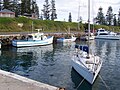 Kiama harbour
 -
 Kiama harbour
 -
 Kiama post office


Notable people[編輯]
- Peter Knott (born 8 August 1956) represented Gilmore from 1993 to 1996 for the Australian Labor Party (ALP).
- Matt Brown (born 1972), member of the New South Wales Legislative Assembly for Kiama[17]
- Charmian Clift (1923–1969), writer and essayist[18]
- Sir George Fuller (1861–1940), Premier of New South Wales[19]
- Orry George Kelly (1897–1964), Academy Award-winning dress designer[20]
- Robbie Maddison (born 1981), freestyle motocross rider[來源請求]
- Josh Morris and Brett Morris, professional rugby league players
- Alfred Percival (Perce) Bullen[21] (1896–1974), circus proprietor
- Charles Edward Devenish Meares[22] (1861–1940), dairy industry organiser
- Frederick Phillimore Howell-Price[23] (1888–1978) soldier
- Joseph Carruthers, Premier of NSW, born in Kiama 1857
References[編輯]
- ^ Budderoo National Park. [12 July 2009]. (原始內容存檔於20 October 2009).
- ^ https://web.archive.org/web/20090321051744/http://www.uow.edu.au/science/eesc/research/UOW002909.html. [12 July 2009]. (原始內容存檔於21 March 2009). 缺少或
|title=為空 (幫助)Missing or empty|title=(help) - ^ Dunn, Elaine M. Kiama: Its region and community 1901 to 1938. ro.uow.edu.au. University of Wollongong. [5 February 2017].
- ^ Cottrell, Rory D.; Tarduno, John A; Roberts, John. The Kiaman Reversed Polarity Superchron at Kiama: Toward a field strength estimate based on single silicate crystals. Physics of the Earth and Planetary Interiors. 2008, 169: 49–58. Bibcode:2008PEPI..169...49C. doi:10.1016/j.pepi.2008.07.041.
- ^ Wooden Terraces. New South Wales State Heritage Register. Department of Planning & Environment. [18 May 2018]. H00472.
 Text is licensed by State of New South Wales (Department of Planning and Environment) under CC-BY 4.0 licence.
- ^ Wooden Terraces. New South Wales State Heritage Register. Department of Planning & Environment. [18 May 2018]. H00473. Text is licensed by State of New South Wales (Department of Planning and Environment) under CC-BY 4.0 licence.
- ^ Masonic Temple. New South Wales State Heritage Register. Department of Planning & Environment. [18 May 2018]. H00474. Text is licensed by State of New South Wales (Department of Planning and Environment) under CC-BY 4.0 licence.
- ^ Kiama Railway Station Group and Turntable. New South Wales State Heritage Register. Department of Planning & Environment. [18 May 2018]. H01176. Text is licensed by State of New South Wales (Department of Planning and Environment) under CC-BY 4.0 licence.
- ^ Kiama Reservoir (WS 0231). New South Wales State Heritage Register. Department of Planning & Environment. [18 May 2018]. H01626. Text is licensed by State of New South Wales (Department of Planning and Environment) under CC-BY 4.0 licence.
- ^ Kiama Reservoir (WS 0232). New South Wales State Heritage Register. Department of Planning & Environment. [18 May 2018]. H01627. Text is licensed by State of New South Wales (Department of Planning and Environment) under CC-BY 4.0 licence.
- ^ CBC Bank (former). New South Wales State Heritage Register. Department of Planning & Environment. [18 May 2018]. H00143. Text is licensed by State of New South Wales (Department of Planning and Environment) under CC-BY 4.0 licence.
- ^ Scots Presbyterian Church, Land and Trees. New South Wales State Heritage Register. Department of Planning & Environment. [18 May 2018]. H00120. Text is licensed by State of New South Wales (Department of Planning and Environment) under CC-BY 4.0 licence.
- ^ Kiama Post Office. New South Wales State Heritage Register. Department of Planning & Environment. [18 May 2018]. H01426. Text is licensed by State of New South Wales (Department of Planning and Environment) under CC-BY 4.0 licence.
- ^ Kiama Ramps additional access ramps Apx E – Visual assessment and urban design strategy
- ^ Template:Cite loa
- ^ Daily Telegraph, 4 September 2009, p.30
- ^ Mr (Matt) Matthew James Brown. Members of Parliament. Parliament of New South Wales. [12 February 2010]. (原始內容存檔於29 March 2010).
- ^ Wheatley, N. The Life and Myth of Charmian Clift. Sydney: Flamingo (Harper Collins). 2001.
- ^ Sir George Warburton Fuller (1861–1940). Members of Parliament. Parliament of New South Wales. [8 February 2010].
- ^ Kelly, Orry George biography at the Australian Dictionary of Biography
- ^ Australian Dictionary of Biography.
- ^ Australian Dictionary of Biography.
- ^ Australian Dictionary of Biography.
外部連結[編輯]
[[Category:新南威尔士州城镇]]