图蓬加托火山
外观
| Tupungato | |
|---|---|
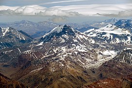
 Aerial view of Tupungato volcano from Argentina. | |
| 最高点 | |
| 海拔 | 6,570米(21,560英尺)[A] |
| 地形突起度 | 2,765米(9,072英尺)[1] |
| 列表 | Ultra |
| 坐标 | 33°21′30″S 69°46′12″W / 33.35833°S 69.77000°W [1] |
| 地理 | |
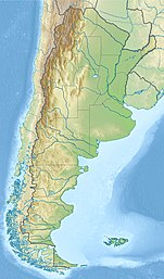
| 位置 | 阿根廷门多萨省 智利圣地亚哥首都大区 |
| 所属山脉 | Principal Cordillera 安地斯山脉 |
| 地质 | |
| 岩石年代 | 更新世[2] |
| 山脉类型 | 火山穹丘[2] |
| 火山岛弧/带 | South Volcanic Zone |
| 最近喷发 | 80万年前[3] |
| 攀山 | |
| 首次登顶 | 1897年,Matthias Zurbriggen和Stuart Vines |
图蓬加托火山(西班牙语:Volcán Tupungato),海拔约6600米,高度2765米,属于南美洲最高的山峰之一,是更新世形成的层状火山,位于智利圣地亚哥首都大区和阿根廷门多萨省接壤的边境。
参考资料
[编辑]- ^ 1.0 1.1 Argentina and Chile, Central Ultra Prominences. Peaklist.
- ^ 2.0 2.1 González Díaz, Emilio F. Contribución al Conocimiento de la Petrografía del Cerro Tupungato (Provincia de Mendoza) y de otras Rocas Efusivas de la Región. Dirección Nacional de Geología y Minería. 1961 [2 August 2022] (西班牙语).
- ^ Tupungato. 全球火山作用计划. 史密森尼学会.

外部链接
[编辑]- Pictures of Mount Tupungato(页面存档备份,存于互联网档案馆)
- Technical information
- Star Dust Plane Crash Mystery (页面存档备份,存于互联网档案馆)
- Andes Mountains (Spanish) [1]
| 这是一篇与阿根廷地理相关的小作品。您可以通过编辑或修订扩充其内容。 |
| 这是一篇与智利地理相关的小作品。您可以通过编辑或修订扩充其内容。 |

