阿什兰 (亚拉巴马州)
外观
| 阿什兰 Ashland | |
|---|---|
| 镇[1] | |
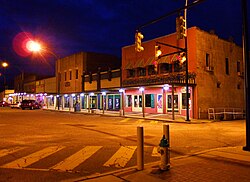
 黄昏时的阿什兰1号街 | |
 阿什兰在亚拉巴马州中的位置 | |
| 坐标:33°16′20″N 85°50′13″W / 33.272206°N 85.836925°W | |
| 国家 | 美国 |
| 州 | 亚拉巴马州 |
| 县 | 克莱县 |
| 建立 | 1867年 |
| 成立市政机关 | 1871年 |
| 语源 | Henry Clay's estate |
| 政府 | |
| • 类型 | 市长议会制 |
| • 市长 | 拉里·J·费迪拿 |
| 面积 | |
| • 总计 | 7.2 平方英里(18.8 平方公里) |
| • 陆地 | 7.2 平方英里(18.7 平方公里) |
| • 水域 | 0 平方英里(0.1 平方公里) |
| 海拔 | 1,119 英尺(341 米) |
| 人口(2007年)[2] | |
| • 总计 | 1,873人 |
| • 密度 | 272.9人/平方英里(104.5人/平方公里) |
| 时区 | 北美中部时区(UTC-6) |
| • 夏时制 | 北美中部时区(UTC-5) |
| ZIP代码 | 36251 |
| 电话区号 | 256 |
| FIPS代码 | 01-02860 |
| GNIS代码 | 0159091 |
| 网站 | http://www.cityofashland.net/ |
阿什兰(英语:Ashland)位于美国亚拉巴马州东部,是克莱县的县治所在[3],面积18.8平方公里。根据2000年人口普查,共有1,965人,其中白人占73.74%、非裔美国人占25.29%。[4]根据2050年人口估计,本镇共有1,885人。[5]
地理
[编辑]阿什兰的座标为33°16′20″N 85°50′13″W / 33.27222°N 85.83694°W(33.272206,-85.836925)。[6]根据2000年人口普查,本城面积为7.3平方英里(18.91平方千米),其中7.2平方英里(18.65平方千米)为陆地,0.04平方英里(0.10平方千米)为水域。[7][8]阿什兰海拔为1,130英尺(340米),是亚拉巴马州海拔最高城市。[9]
参考文献
[编辑]- ^ U.S.Census change list. [2013-08-12]. (原始内容存档于2010-08-06).
- ^ Annual Estimates of the Population for Incorporated Places in Alabama. United States Census Bureau. July 10, 2008 [July 14, 2008]. (原始内容存档于2008-08-01).
- ^ Find a County. National Association of Counties. [2011-06-07].
- ^ American FactFinder. United States Census Bureau. [2008-01-31].
- ^ Population Estiames- Alabama. United States Census Bureau. [January 20, 2010]. (原始内容 (CSV)存档于2010-02-10).
- ^ US Gazetteer files: 2010, 2000, and 1990. United States Census Bureau. 2011-02-12 [2011-04-23].
- ^ US Gazetteer files 2010. United States Census Bureau. [2013-01-25]. (原始内容存档于2012-07-14).
- ^ Geographic Comparison Table. American Fast Facts. United States Census Bureau. [2013-08-12]. (accessdate =13 January 2010 原始内容 请检查
|url=值 (帮助)存档于2020-02-12). - ^ US Board on Geographic Names. United States Geological Survey. 2007-10-25 [2008-01-31].

