
File:Texaco Road and Texaco Road North Map.png

本预览的尺寸:556 × 599像素。 其他分辨率:223 × 240像素 | 445 × 480像素 | 770 × 830像素。
原始文件 (770 × 830像素,文件大小:1,022 KB,MIME类型:image/png)
摘要
| 描述 |
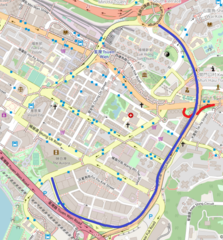
中文(香港):德士古道及德士古道北地圖,走綫以藍色表示(德士古交匯處以紅色表示)。 |
| 日期 | |
| 来源 | https://www.openstreetmap.org/#map=16/22.3695/114.1161 |
| 作者 | OpenStreetMap contributors |
许可协议
| This work contains information from OpenStreetMap, which is made available under the Open Database License (ODbL).
The ODbL does not require any particular license for maps produced from ODbL data. Prior to 1 August 2020, map tiles produced by the OpenStreetMap Foundation were licensed under the CC-BY-SA-2.0 license. Maps produced by other people may be subject to other licences. |
文件历史
点击某个日期/时间查看对应时刻的文件。
| 日期/时间 | 缩略图 | 大小 | 用户 | 备注 | |
|---|---|---|---|---|---|
| 当前 | 2020年5月3日 (日) 11:30 | | 770 × 830(1,022 KB) | Sanmosa | Add Texaco Interchange |
| 2020年5月1日 (五) 11:54 |  | 770 × 830(1,023 KB) | Sanmosa | Uploaded a work by OpenStreetMap contributors from https://www.openstreetmap.org/#map=16/22.3695/114.1161 with UploadWizard |
文件用途
以下页面使用本文件: