錫河
外觀
| 錫河 Maenam Chi | |
|---|---|
 錫河 | |
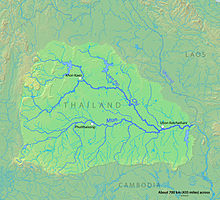
 蒙河流域地形圖 | |
| 流域 | |
| 源頭 | |
| • 位置 | 猜也奔府 |
| 河口 | |
| • 位置 | 四色菊府蒙河 |
| • 海拔 | 110米(360英尺) |
| 流域面積 | 49,480 km2(19,100 sq mi) |
| 本貌 | |
| 長度 | 1,047 km(651 mi) |
| 流量 | |
| • 地點 | 益梭通府 |
| • 平均流量 | 290 m3/s(10,000 cu ft/s) |
| • 最大流量 | 3,960 m3/s(140,000 cu ft/s) |
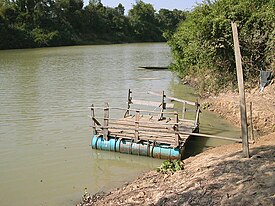
錫河(泰語:แม่น้ำชี,音素換寫:Mæ̀n̂ả chī,皇家轉寫:Maenam Chi,發音:[mɛ̂ːnáːm t͡ɕʰīː]),泰國河流,為全境位於泰國的河流中最長的一條(765公里(475英里))。錫河是蒙河的一條支流,屬於湄公河水系。在雨季時,錫河時常氾濫[1]。
河道
[編輯]錫河源自於碧差汶山脈,向東流經依善地區的猜也奔府、坤敬府,以及瑪哈沙拉堪府。之後於黎逸府轉向南流,流經益梭通府,並於四色菊府干他拉隆縣匯入蒙河,錫河年流量約9.3立方公里(2.2立方英里)[2]。
1718年,占巴塞王國建立後,諾卡薩王派出3,000人從湄公河東岸移居西岸,並在錫河流域建立了第一個佬族聚落,並於今天的黎逸府金地縣建立了第一個佬族的勐[3]。
參考文獻
[編輯]- ^ Thailand: Water level in Chi River still high. ReliefWeb. [2017-11-25]. (原始內容存檔於2019-07-01) (英語).
- ^ Delineation of flood hazards and risk mapping in the Chi River Basin (PDF). [2017-11-25]. (原始內容存檔 (PDF)於2021-01-21).
- ^ Brow, James, Population, land and structural change in Sri Lanka and Thailand, Contributions to Asian studies (Kogan Page), 1976, (Issue 9): 47 [2017-11-25], ISBN 90-04-04529-5, (原始內容存檔於2016-05-22)
延伸閱讀
[編輯]- C. Pawattana; N. K. Tripathi; S. Weesakul. Floodwater retention planning using GIS and hydrodynamic model: a case study for the Chi River Basin, Thailand. Environmental Informatics Archives (ISEIS – International Society for Environmental Information Sciences). 2007, 5: 548–556 [March 5, 2012]. EIA07-056.[永久失效連結]
- Choopug Suttisa. Civil Society in the Chi River, Northeast Thailand (PDF). Massey University, New Zealand: 1–17. 2011 [March 5, 2012]. (原始內容 (Ph.D.)存檔於April 26, 2012).
Abstract: This paper aims to examine the concept of civil society in the rural communities in the Chi River, Northeast Thailand. It focuses on the questions of what civil society means in the Thai rural context, what factors make civil society proactive and how civil society is activated. By using participatory action research (PAR) as the main methodology to answer the inquiries. The paper addresses the new term of 『grounded civil society』 which was created through the research process in two case studies. The research determines that two elements activated grounded civil society are from outside and inside factors. The outside factors included the negative effect of government development projects and the intervention of the participatory action research, which stimulate local people to engage in civil society. The inside factors are the poor economic conditions of the villagers and the social capital existing in the communities. The paper concludes with an analysis of the causal links between social capital and civil society which claims that social capital facilitated the creation of civil society.
