跳至內容

模板:Infobox airport/testcases

維基百科,自由的百科全書

測試 1 Public airport

[編輯]

Dallas-Fort Worth International Airport

左右對比
{{Infobox airport}}{{Infobox airport/sandbox}}
Dallas-Fort Worth International Airport
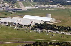
An aerial view of Dallas-Fort Worth International Airport
概覽
機場類型Public
所有者City of Dallas City of Fort Worth
營運者DFW Airport Board
服務城市Dallas/Fort Worth
海拔高度607英尺(185米)
座標32°53′49″N 097°02′17″W / 32.89694°N 97.03806°W / 32.89694; -97.03806
網址www.dfwairport.com
地圖
Dallas-Fort Worth International Airport在德克薩斯州的位置
Dallas-Fort Worth International Airport
Location within Texas
Dallas-Fort Worth International Airport在美國的位置
Dallas-Fort Worth International Airport
Location in United States
跑道
方向 長度 表面
英尺 公尺
13L/31R 9,000 2,743 Concrete
13R/31L 9,301 2,835 Concrete
17C/35C 13,401 4,085 Concrete
17L/35R 8,500 2,591 Concrete
17R/35L 13,401 4,085 Concrete
18L/36R 13,400 4,084 Concrete
18R/36L 13,400 4,084 Concrete
直升機停機坪
編號 長度 表面
英尺 公尺
H1 158 48 Concrete
統計數據(2005)
Passengers59,176,265
Aircraft operations711,878
Metric tonnes of cargo741,432
Sources: airport website[1] and FAA[2]
Dallas-Fort Worth International Airport
An aerial view of Dallas-Fort Worth International Airport
概覽
機場類型Public
所有者City of Dallas City of Fort Worth
營運者DFW Airport Board
服務城市Dallas/Fort Worth
海拔高度607英尺(185米)
坐標32°53′49″N 097°02′17″W / 32.89694°N 97.03806°W / 32.89694; -97.03806
網址www.dfwairport.com
地圖
Dallas-Fort Worth International Airport在德克薩斯州的位置
Dallas-Fort Worth International Airport
Location within Texas
Dallas-Fort Worth International Airport在美國的位置
Dallas-Fort Worth International Airport
Location in United States
跑道
方向 長度 表面
英尺 公尺
13L/31R 9,000 2,743 Concrete
13R/31L 9,301 2,835 Concrete
17C/35C 13,401 4,085 Concrete
17L/35R 8,500 2,591 Concrete
17R/35L 13,401 4,085 Concrete
18L/36R 13,400 4,084 Concrete
18R/36L 13,400 4,084 Concrete
直升機停機坪
編號 長度 表面
英尺 公尺
H1 158 48 Concrete
統計數據(2005)
Passengers59,176,265
Aircraft operations711,878
Metric tonnes of cargo741,432
Sources: airport website[1] and FAA[2]

測試 2 Military airport

[編輯]

Wright-Patterson Air Force Base

左右對比
{{Infobox airport}}{{Infobox airport/sandbox}}
Wright-Patterson Air Force Base


概覽
機場類型Military: Air Force Base
營運者United States Air Force
地理位置Dayton, Ohio
使用期間1948 - present
司令官
海拔高度823英尺(251米)
座標39°49′34″N 084°02′54″W / 39.82611°N 84.04833°W / 39.82611; -84.04833
網址www.wpafb.af.mil
地圖
Wright-Patterson Air Force Base在俄亥俄州的位置
Wright-Patterson Air Force Base
Location within Ohio
跑道
方向 長度 表面
英尺 公尺
5L/23R 12,601 3,841 PEM
5R/23L 7,000 2,134 Asphalt
Sources: official website[3] and FAA[4]
Wright-Patterson Air Force Base


概覽
機場類型Military: Air Force Base
營運者United States Air Force
地理位置Dayton, Ohio
使用期間1948 - present
司令官
海拔高度823英尺(251米)
坐標39°49′34″N 084°02′54″W / 39.82611°N 84.04833°W / 39.82611; -84.04833
網址www.wpafb.af.mil
地圖
Wright-Patterson Air Force Base在俄亥俄州的位置
Wright-Patterson Air Force Base
Location within Ohio
跑道
方向 長度 表面
英尺 公尺
5L/23R 12,601 3,841 PEM
5R/23L 7,000 2,134 Asphalt
Sources: official website[3] and FAA[4]

測試 3 New parameters: pushpin_mark, pushpin_marksize

[編輯]

Christmas Island Airport

左右對比
{{Infobox airport}}{{Infobox airport/sandbox}}
Christmas Island Airport
概覽
機場類型Public
營運者PDL Toll
地理位置Christmas Island
海拔高度916英尺(279米)
座標10°27.0′S 105°41.4′E / 10.4500°S 105.6900°E / -10.4500; 105.6900
地圖
YPXM在印度洋的位置
YPXM
YPXM
Location on a map of the Indian Ocean
跑道
方向 長度 表面
公尺 英尺
18/36 2,103 6,900 Asphalt
Sources: Australian AIP[5]
Christmas Island Airport
概覽
機場類型Public
營運者PDL Toll
地理位置Christmas Island
海拔高度916英尺(279米)
坐標10°27.0′S 105°41.4′E / 10.4500°S 105.6900°E / -10.4500; 105.6900
地圖
YPXM在印度洋的位置
YPXM
YPXM
Location on a map of the Indian Ocean
跑道
方向 長度 表面
公尺 英尺
18/36 2,103 6,900 Asphalt
Sources: Australian AIP[5]

測試 4 Number autoformat and autoconvert ft → m

[編輯]

Dallas-Fort Worth International Airport

左右對比
{{Infobox airport}}{{Infobox airport/sandbox}}
Dallas-Fort Worth International Airport
An aerial view of Dallas-Fort Worth International Airport
概覽
機場類型Public
所有者City of Dallas City of Fort Worth
營運者DFW Airport Board
服務城市Dallas/Fort Worth
海拔高度607英尺(185公尺)
座標32°53′49″N 097°02′17″W / 32.89694°N 97.03806°W / 32.89694; -97.03806
網址www.dfwairport.com
地圖
Dallas-Fort Worth International Airport在德克薩斯州的位置
Dallas-Fort Worth International Airport
Location within Texas
跑道
方向 長度 表面
英尺 公尺
13L/31R 9,000 2,743 Concrete
13R/31L 9,301 2,835 Concrete
17C/35C 13,401 4,085 Concrete
17L/35R 8,500 2,591 Concrete
17R/35L 13,401 4,085 Concrete
18L/36R 13,400 4,084 Concrete
18R/36L 13,400 4,084 Concrete
直升機停機坪
編號 長度 表面
英尺 公尺
H1 158 48 Concrete
統計數據(2005)
Passengers59176265
Aircraft operations711878
Metric tonnes of cargo741432
Sources: airport website[6] and FAA[7]
Dallas-Fort Worth International Airport
An aerial view of Dallas-Fort Worth International Airport
概覽
機場類型Public
所有者City of Dallas City of Fort Worth
營運者DFW Airport Board
服務城市Dallas/Fort Worth
海拔高度607英尺(185公尺)
坐標32°53′49″N 097°02′17″W / 32.89694°N 97.03806°W / 32.89694; -97.03806
網址www.dfwairport.com
地圖
Dallas-Fort Worth International Airport在德克薩斯州的位置
Dallas-Fort Worth International Airport
Location within Texas
跑道
方向 長度 表面
英尺 公尺
13L/31R 9,000 2,743 Concrete
13R/31L 9,301 2,835 Concrete
17C/35C 13,401 4,085 Concrete
17L/35R 8,500 2,591 Concrete
17R/35L 13,401 4,085 Concrete
18L/36R 13,400 4,084 Concrete
18R/36L 13,400 4,084 Concrete
直升機停機坪
編號 長度 表面
英尺 公尺
H1 158 48 Concrete
統計數據(2005)
Passengers59176265
Aircraft operations711878
Metric tonnes of cargo741432
Sources: airport website[6] and FAA[7]

測試 5 Number autoformat and autoconvert m → ft

[編輯]

Helsinki Airport

左右對比
{{Infobox airport}}{{Infobox airport/sandbox}}
Helsinki Airport

Helsinki-Vantaan lentoasema
Helsingfors-Vanda flygplats
概覽
機場類型Public
營運者Finavia
服務城市Helsinki
地理位置Vantaa, Finland
樞紐航空公司
海拔高度55米(180英尺)
座標60°19′02″N 024°57′48″E / 60.31722°N 24.96333°E / 60.31722; 24.96333
網址www.helsinki-vantaa.fi
地圖
HEL在芬蘭的位置
HEL
HEL
Location within Finland
跑道
方向 長度 表面
公尺 英尺
04R/22L 3,440 11,286 Asphalt
04L/22R 3,060 10,039 Asphalt
15/33 2,901 9,518 Asphalt
統計數據(2010)
Passengers12884500
Landings88480
Source: AIP Finland[8]
Statistics from Finavia[9]
Helsinki Airport

Helsinki-Vantaan lentoasema
Helsingfors-Vanda flygplats
概覽
機場類型Public
營運者Finavia
服務城市Helsinki
地理位置Vantaa, Finland
樞紐航空公司
海拔高度55米(180英尺)
坐標60°19′02″N 024°57′48″E / 60.31722°N 24.96333°E / 60.31722; 24.96333
網址www.helsinki-vantaa.fi
地圖
HEL在芬蘭的位置
HEL
HEL
Location within Finland
跑道
方向 長度 表面
公尺 英尺
04R/22L 3,440 11,286 Asphalt
04L/22R 3,060 10,039 Asphalt
15/33 2,901 9,518 Asphalt
統計數據(2010)
Passengers12884500
Landings88480
Source: AIP Finland[8]
Statistics from Finavia[9]

測試 6 Autoconvert m → ft, metric number manually formatted

[編輯]

Helsinki Airport

左右對比
{{Infobox airport}}{{Infobox airport/sandbox}}
Helsinki Airport

Helsinki-Vantaan lentoasema
Helsingfors-Vanda flygplats
概覽
機場類型Public
營運者Finavia
服務城市Helsinki
地理位置Vantaa, Finland
樞紐航空公司
海拔高度55米(180英尺)
座標60°19′02″N 024°57′48″E / 60.31722°N 24.96333°E / 60.31722; 24.96333
網址www.helsinki-vantaa.fi
地圖
HEL在芬蘭的位置
HEL
HEL
Location within Finland
跑道
方向 長度 表面
公尺 英尺
04R/22L 3,440 11,286 Asphalt
04L/22R 3,060 10,039 Asphalt
15/33 2,901 9,518 Asphalt
統計數據(2010)
Passengers12,884,500
Landings88,480
Source: AIP Finland[8]
Statistics from Finavia[9]
Helsinki Airport

Helsinki-Vantaan lentoasema
Helsingfors-Vanda flygplats
概覽
機場類型Public
營運者Finavia
服務城市Helsinki
地理位置Vantaa, Finland
樞紐航空公司
海拔高度55米(180英尺)
坐標60°19′02″N 024°57′48″E / 60.31722°N 24.96333°E / 60.31722; 24.96333
網址www.helsinki-vantaa.fi
地圖
HEL在芬蘭的位置
HEL
HEL
Location within Finland
跑道
方向 長度 表面
公尺 英尺
04R/22L 3,440 11,286 Asphalt
04L/22R 3,060 10,039 Asphalt
15/33 2,901 9,518 Asphalt
統計數據(2010)
Passengers12,884,500
Landings88,480
Source: AIP Finland[8]
Statistics from Finavia[9]

測試 7 Only metric data without "metric-rwy=y"

[編輯]

Helsinki Airport

左右對比
{{Infobox airport}}{{Infobox airport/sandbox}}
Helsinki Airport

Helsinki-Vantaan lentoasema
Helsingfors-Vanda flygplats
概覽
機場類型Public
營運者Finavia
服務城市Helsinki
地理位置Vantaa, Finland
樞紐航空公司
海拔高度180英尺(55米)
座標60°19′02″N 024°57′48″E / 60.31722°N 24.96333°E / 60.31722; 24.96333
網址www.helsinki-vantaa.fi
地圖
HEL在芬蘭的位置
HEL
HEL
Location within Finland
跑道
方向 長度 表面
英尺 公尺
04R/22L 3,440 Asphalt
04L/22R 3,060 Asphalt
15/33 2,901 Asphalt
統計數據(2010)
Passengers12884500
Landings88480
Source: AIP Finland[8]
Statistics from Finavia[9]
Helsinki Airport

Helsinki-Vantaan lentoasema
Helsingfors-Vanda flygplats
概覽
機場類型Public
營運者Finavia
服務城市Helsinki
地理位置Vantaa, Finland
樞紐航空公司
海拔高度180英尺(55米)
坐標60°19′02″N 024°57′48″E / 60.31722°N 24.96333°E / 60.31722; 24.96333
網址www.helsinki-vantaa.fi
地圖
HEL在芬蘭的位置
HEL
HEL
Location within Finland
跑道
方向 長度 表面
英尺 公尺
04R/22L 3,440 Asphalt
04L/22R 3,060 Asphalt
15/33 2,901 Asphalt
統計數據(2010)
Passengers12884500
Landings88480
Source: AIP Finland[8]
Statistics from Finavia[9]

測試 8 Mix of imperial/metric data with "metric-rwy=y" but without "metric-elev=y"

[編輯]

Paris-Charles de Gaulle Airport

左右對比
{{Infobox airport}}{{Infobox airport/sandbox}}
Paris-Charles de Gaulle Airport

Aéroport Paris-Charles-de-Gaulle

Roissy Airport
概覽
機場類型Public
所有者/營運者Aéroports de Paris
服務城市Paris
地理位置25 km(16 mi) NE of Paris
樞紐航空公司
海拔高度392英尺(119公尺)
座標49°00′35″N 002°32′52″E / 49.00972°N 2.54778°E / 49.00972; 2.54778
網址http://www.aeroportsdeparis.fr/ADP/en-gb
地圖
CDG在法蘭西島(地區)的位置
CDG
CDG
Location in Île-de-France
跑道
方向 長度 表面
公尺 英尺
08L/26R 4,215 13,829 Asphalt
08R/26L 2,700 8,858 Concrete
09L/27R 2,700 8,858 Asphalt
09R/27L 4,200 13,780 Asphalt
統計數據(2010)
Aircraft movements525314
Passengers58164612
Source: French AIP[5]
Paris-Charles de Gaulle Airport

Aéroport Paris-Charles-de-Gaulle

Roissy Airport
概覽
機場類型Public
所有者/營運者Aéroports de Paris
服務城市Paris
地理位置25 km(16 mi) NE of Paris
樞紐航空公司
海拔高度392英尺(119公尺)
坐標49°00′35″N 002°32′52″E / 49.00972°N 2.54778°E / 49.00972; 2.54778
網址http://www.aeroportsdeparis.fr/ADP/en-gb
地圖
CDG在法蘭西島(地區)的位置
CDG
CDG
Location in Île-de-France
跑道
方向 長度 表面
公尺 英尺
08L/26R 4,215 13,829 Asphalt
08R/26L 2,700 8,858 Concrete
09L/27R 2,700 8,858 Asphalt
09R/27L 4,200 13,780 Asphalt
統計數據(2010)
Aircraft movements525314
Passengers58164612
Source: French AIP[5]

測試 9 Missing data

[編輯]

Sheghnan Airport

左右對比
{{Infobox airport}}{{Infobox airport/sandbox}}
Shughnan Airport
概覽
地理位置Shughnan
海拔高度6,750英尺(2,057公尺)
座標37°29′55.51″N 71°30′25.25″E / 37.4987528°N 71.5070139°E / 37.4987528; 71.5070139
跑道
方向 長度 表面
英尺 公尺
16/34 Gravel
Shughnan Airport
概覽
地理位置Shughnan
海拔高度6,750英尺(2,057公尺)
坐標37°29′55.51″N 71°30′25.25″E / 37.4987528°N 71.5070139°E / 37.4987528; 71.5070139
跑道
方向 長度 表面
英尺 公尺
16/34 Gravel

測試 10 Striken runway data

[編輯]

Galkacyo Airport

左右對比
{{Infobox airport}}{{Infobox airport/sandbox}}
Galkacyo International Airport
概覽
地理位置Galkacyo
海拔高度975英尺(297公尺)
座標6°46′51.16″N 47°27′15.89″E / 6.7808778°N 47.4544139°E / 6.7808778; 47.4544139
地圖
Galkacyo International Airport在索馬利亞的位置
Galkacyo International Airport
跑道
方向 長度 表面
英尺 公尺
05R/23L 9,859 3,006 Asphalt
05L/23R 9,859 3,006 Dirt
Galkacyo International Airport
概覽
地理位置Galkacyo
海拔高度975英尺(297公尺)
坐標6°46′51.16″N 47°27′15.89″E / 6.7808778°N 47.4544139°E / 6.7808778; 47.4544139
地圖
Galkacyo International Airport在索馬利亞的位置
Galkacyo International Airport
跑道
方向 長度 表面
英尺 公尺
05R/23L 9,859 3,006 Asphalt
05L/23R 9,859 3,006 Dirt

測試 11 Elevation rounding

[編輯]

Fukui Airport

左右對比
{{Infobox airport}}{{Infobox airport/sandbox}}
Fukui Airport
概覽
機場類型Public
營運者Fukui Prefecture
地理位置Harue, Japan
海拔高度18英尺(5公尺)
座標36°08′34″N 136°13′26″E / 36.14278°N 136.22389°E / 36.14278; 136.22389
地圖
RJNF在日本的位置
RJNF
RJNF
Location in Japan
跑道
方向 長度 表面
公尺 英尺
18/36 1,200 3,937 Concrete
Source: Japanese AIP at AIS Japan[5]
Fukui Airport
概覽
機場類型Public
營運者Fukui Prefecture
地理位置Harue, Japan
海拔高度18英尺(5公尺)
坐標36°08′34″N 136°13′26″E / 36.14278°N 136.22389°E / 36.14278; 136.22389
地圖
RJNF在日本的位置
RJNF
RJNF
Location in Japan
跑道
方向 長度 表面
公尺 英尺
18/36 1,200 3,937 Concrete
Source: Japanese AIP at AIS Japan[5]

測試 12 New parameter: pushpin_relief

[編輯]

N'Djamena International Airport

左右對比
{{Infobox airport}}{{Infobox airport/sandbox}}
N'Djamena International Airport
概覽
機場類型Public / Military
服務城市N'Djamena, Chad
海拔高度968英尺(295公尺)
座標12°08′01″N 015°02′02″E / 12.13361°N 15.03389°E / 12.13361; 15.03389
地圖
FTTJ在查德的位置
FTTJ
FTTJ
Location of airport in Chad
跑道
方向 長度 表面
公尺 英尺
05/23 2,800 9,186 Asphalt
N'Djamena International Airport
概覽
機場類型Public / Military
服務城市N'Djamena, Chad
海拔高度968英尺(295公尺)
坐標12°08′01″N 015°02′02″E / 12.13361°N 15.03389°E / 12.13361; 15.03389
地圖
FTTJ在查德的位置
FTTJ
FTTJ
Location of airport in Chad
跑道
方向 長度 表面
公尺 英尺
05/23 2,800 9,186 Asphalt

測試 13 Public heliport (no runways)

[編輯]

London Heliport

左右對比
{{Infobox airport}}{{Infobox airport/sandbox}}
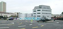
London Heliport
概覽
機場類型Public
所有者Reuben Brothers
營運者The London Airport Ltd.
地理位置London
海拔高度18英尺(5公尺)
座標51°28′12″N 000°10′46″W / 51.47000°N 0.17944°W / 51.47000; -0.17944
網址www.londonheliport.co.uk
地圖
EGLW在Greater London的位置
EGLW
EGLW
Location in Greater London
直升機停機坪
編號 長度 表面
公尺 英尺
03/21 38 × 16 125 × 52 Concrete
Sources: UK AIP at NATS
London Heliport
概覽
機場類型Public
所有者Reuben Brothers
營運者The London Airport Ltd.
地理位置London
海拔高度18英尺(5公尺)
坐標51°28′12″N 000°10′46″W / 51.47000°N 0.17944°W / 51.47000; -0.17944
網址www.londonheliport.co.uk
地圖
EGLW在Greater London的位置
EGLW
EGLW
Location in Greater London
直升機停機坪
編號 長度 表面
公尺 英尺
03/21 38 × 16 125 × 52 Concrete
Sources: UK AIP at NATS

測試參考文獻

[編輯]
  1. ^ Dallas-Fort Worth International Airport, official web site
  2. ^ DFW的美國聯邦航空局機場記錄 (PDF)
  3. ^ Wright-Patterson Air Force Base (official site)
  4. ^ FFO的美國聯邦航空局機場記錄 (PDF)
  5. ^ 5.0 5.1 5.2 YPXM – CHRISTMAS ISLAND (PDF)。源自澳大利亞航空服務公司英語Airservices AustraliaAIP航路補充資料,自2022-03-24生效。 引用錯誤:帶有name屬性「AIP」的<ref>標籤用不同內容定義了多次
  6. ^ Dallas-Fort Worth International Airport, official web site
  7. ^ DFW的美國聯邦航空局機場記錄 (PDF)
  8. ^ 8.0 8.1 8.2 EFHK Helsinki-Vantaa (PDF). AIP Suomi / Finland. Finavia: EFHK AD 2.1, pp. 1–7. 17 December 2009 [19 February 2010]. 
  9. ^ 9.0 9.1 9.2 Finavia's Air Traffic Statistics 2010 (PDF). Vantaa: Finavia: 7, 9. [15 July 2011]. 
  10. ^ Delta Air Lines Newsroom – Press Kit. News.delta.com. 7 January 2010 [28 January 2011]. 
  11. ^ Galcaio (GLK) Somalia