
梅杜莎槽溝層:修订间差异
无编辑摘要 |
无编辑摘要 |
||
| 第1行: | 第1行: | ||
{{Link style|time=2015-12-11T07:21:08+00:00}} |
|||
{{Infobox feature on celestial object |
{{Infobox feature on celestial object |
||
|name |
|name= 梅杜莎槽沟层 |
||
|image |
|image= Medusae Fossae based on day THEMIS.png |
||
|caption |
|caption=[[热辐射成像系统]]拍摄的梅杜莎槽沟层全时图像 |
||
|coordinates = {{coord|3.2|S|163.0|W|globe:mars_type:landmark|display=inline,title}} |
|coordinates = {{coord|3.2|S|163.0|W|globe:mars_type:landmark|display=inline,title}} |
||
|length |
|length = 333 公里 |
||
}} |
}} |
||
'''梅杜莎槽沟层'''(Medusae Fossae Formation)是[[火星]]上一处可能起源于[[火山]]的大型地质单元<ref name=esa-mff>{{cite web|title=The Medusa Fossae formation on Mars|url=http://www.esa.int/Our_Activities/Space_Science/Mars_Express/The_Medusa_Fossae_formation_on_Mars/(print)|publisher=[[European Space Agency]]|date=29 March 2005}}</ref>,它取名自[[希腊神话]]中的[[美杜莎|梅杜莎]],而”槽沟”(Fossae)是[[拉丁语]]中“深沟”之意。该地貌约位于南纬5°、东经213°处,横跨[[塔尔西斯]]和[[埃律西昂]]火山区附近的[[火星分界|高-低地边界]]区,梅杜莎槽沟层范围涵盖了五个区:[[亚马孙区 (火星)|亚马逊区]]、[[塔尔西斯区]]、[[门农区]]、[[埃律西昂区]]和[[埃俄利斯区]] |
|||
'''梅杜莎槽溝層'''('''Medusae Fossae Formation''','''MFF''')是[[火星]]赤道上綿延約5500公里的獨特沉積構造,成因至今仍未明瞭。位於[[埃律西昂平原]]和[[亞馬遜平原 (火星)|亞馬遜平原]]南方,[[火星分界|火星南北地形差異的分界線]]上。[[層 (地層)|層]]([[:en:Formation (stratigraphy)|Formation]])是[[岩層學]]([[:en:Lithostratigraphy|Lithostratigraphy]])中岩層的基本單位。<ref>[http://www.gl.ntu.edu.tw/file/course/94_2/95field_YangCN.ppt#286,80, 投影片1 - 台大地質系]{{dead link|date=2018年3月 |bot=InternetArchiveBot |fix-attempted=yes }}第80頁</ref>此地層以位於其中、{{coord|3.16|S|197.0|E|globe:Mars|name=梅杜莎槽溝(Medusae Fossae)}}的梅杜莎槽溝(Medusae Fossae)命名。 |
|||
梅杜莎槽沟层为沿火星[[赤道]](不连续)绵延超过5000公里的软质、易风化沉积物区,其面积相当于美国大陆面积的20%<ref name=pmid30030425>{{cite journal |doi=10.1038/s41467-018-05291-5 |pmid=30030425 |pmc=6054634 |title=The Medusae Fossae Formation as the single largest source of dust on Mars |journal=Nature Communications |volume=9 |issue=1 |pages=2867 |year=2018 |last1=Ojha |first1=Lujendra |last2=Lewis |first2=Kevin |last3=Karunatillake |first3=Suniti |last4=Schmidt |first4=Mariek |bibcode=2018NatCo...9.2867O }}</ref>。有时,该地层看起来像一片平坦且起伏平缓的地表,但在一些地方,因风蚀而形成一些山脊和沟槽<ref name=esa-mff/>。雷达成像显示,该地区可能含有极多孔岩石(例如火山灰)或类似冰川的厚冰层,其数量与火星南极冰盖下储量大致相同<ref>{{cite journal |doi=10.1126/science.1148112 |pmid=17975034 |lay-url=https://www.newscientist.com/article/dn12866-vast-amount-of-water-ice-may-lie-on-martian-equator/ |laysource=NewScientist |laydate=November 1, 2007 |title=Radar Sounding of the Medusae Fossae Formation Mars: Equatorial Ice or Dry, Low-Density Deposits? |journal=Science |volume=318 |issue=5853 |pages=1125–1128 |year=2007 |last1=Watters |first1=T. R. |last2=Campbell |first2=B. |last3=Carter |first3=L. |last4=Leuschen |first4=C. J. |last5=Plaut |first5=J. J. |last6=Picardi |first6=G. |last7=Orosei |first7=R. |last8=Safaeinili |first8=A. |last9=Clifford |first9=S. M. |last10=Farrell |first10=W. M. |last11=Ivanov |first11=A. B. |last12=Phillips |fi rst12=R. J. |last13=Stofan |first13=E. R. |bibcode=2007Sci...318.1125W }}</ref><ref>{{cite journal |bibcode=2016LPI....47.1869O |title=Radar Sounding by MARSIS over Lucus Planum, Mars |journal=Lunar and Planetary Science Conference |issue=1903 |pages=1869 |last1=Orosei |first1=R. |last2=Cantini |first2=F. |last3=Caprarelli |first3=G. |last4=Carter |first4=L. M. |last5=Papiano |first5=I. |last6=Rossi |first6=A. P. |year=2016 }}</ref>。通过使用火星全球气候模型模拟,以劳拉·克伯(Laura Kerber)为首的一组研究人员发现,梅杜莎槽沟层可能形成于[[阿波里那山]]、[[阿尔西亚山]]和[[帕弗尼斯山]]所喷发的火山灰<ref>{{cite journal |doi=10.1016/j.icarus.2012.03.016 |title=The dispersal of pyroclasts from ancient explosive volcanoes on Mars: Implications for the friable layered deposits |journal=Icarus |volume=219 |issue=1 |pages=358–381 |year=2012 |last1=Kerber |first1=Laura |last2=Head |first2=James W. |last3=Madeleine |first3=Jean-Baptiste |last4=Forget |first4=François |last5=Wilson |first5=Lionel |bibcode=2012Icar..219..358K }}</ref>。相关的细粒成分提供了进一步证据。该地区几乎没有雷达回波,鉴于这一原因,它也被称为“隐形”区<ref>{{cite book |first=Nadine G. |last=Barlow |title=Mars: an introduction to its interior, surface and atmosphere |url=https://archive.org/details/marsintroduction00barl_258 |url-access=limited |publisher=[[Cambridge University Press]] |location=Cambridge, UK |date=2008 |pages=[https://archive.org/details/marsintroduction00barl_258/page/n84 75]–76 |isbn=978-0-521-85226-5 }}</ref>。该地层被划分为三个单元(上、中、下子单元),都属于亚马逊纪,属于火星地质史上最年轻的时代<ref>{{cite journal |doi=10.3133/i1802B |citeseerx=10.1.1.457.7583 |title=Geologic map of the eastern equatorial region of Mars |first1=Ronald |last1=Greeley |first2=J.E. |last2=Guest |year=1987 }}</ref>。其元素成分的比较表明,梅杜莎槽沟层是火星表面尘埃的主要来源地<ref name=pmid30030425/>。2018年7月,研究人员报告称,事实上,[[火星]]上最大单一尘埃来源地为梅杜莎槽沟层<ref name=pmid30030425/>。 |
|||
{| class="wikitable" |
|||
|- |
|||
|<center> |
|||
{{Image label begin|image=Medusae Fossae Formation topo.jpg |width={{{width|815}}}|float={{{float|none}}}}} |
|||
{{Image label|x=0.206|y=0.178|scale={{{width|815}}}|text=<big>'''1'''</big>|color=#000000}} |
|||
{{Image label|x=0.276|y=0.181|scale={{{width|815}}}|text=<big>'''2'''</big>|color=#000000}} |
|||
{{Image label|x=0.436|y=0.199|scale={{{width|815}}}|text=<big>'''3'''</big>|color=#000000}} |
|||
{{Image label|x=0.461|y=0.222|scale={{{width|815}}}|text=<big>'''4'''</big>|color=#000000}} |
|||
{{Image label|x=0.476|y=0.264|scale={{{width|815}}}|text=<big>'''5'''</big>|color=#000000}} |
|||
{{Image label|x=0.476|y=0.181|scale={{{width|815}}}|text=<big>'''6'''</big>|color=#000000}} |
|||
{{Image label|x=0.516|y=0.201|scale={{{width|815}}}|text=<big>'''7'''</big>|color=#000000}} |
|||
{{Image label|x=0.536|y=0.228|scale={{{width|815}}}|text=<big>'''8'''</big>|color=#000000}} |
|||
{{Image label|x=0.641|y=0.198|scale={{{width|815}}}|text=<big>'''9'''</big>|color=#000000}} |
|||
{{Image label|x=0.664|y=0.210|scale={{{width|815}}}|text=<big>'''10'''</big>|color=#000000}} |
|||
{{Image label|x=0.694|y=0.134|scale={{{width|815}}}|text=<big>'''11'''</big>|color=#000000}} |
|||
{{Image label|x=0.764|y=0.187|scale={{{width|815}}}|text=<big>'''12'''</big>|color=#000000}} |
|||
{{Image label|x=0.784|y=0.195|scale={{{width|815}}}|text=<big>'''13'''</big>|color=#000000}} |
|||
{{Image label|x=0.797|y=0.136|scale={{{width|815}}}|text=<big>'''14'''</big>|color=#000000}} |
|||
{{Image label|x=0.916|y=0.144|scale={{{width|815}}}|text=<big>'''15'''</big>|color=#000000}} |
|||
{{Image label end}} |
|||
</center>[[File:magnify-clip.png|right|15px|link=File:Medusae Fossae Formation topo.jpg]]<small>梅杜莎槽沟层周边区域地形图,中央为緯度0度、东经180度,每格為纬度、经度均为10度,[[麦卡托投影]]。<ref>[http://www.nasm.si.edu/research/ceps/research/mars/zimbelman_medusae.cfm Geologic Mapping of the Medusae Fossae Formation, Mars] {{webarchive|url=https://web.archive.org/web/20090420235210/http://www.nasm.si.edu/research/ceps/research/mars/zimbelman_medusae.cfm |date=2009-04-20 }} Center for Earth and Planetary Studies, Smithsonion National Air and Space Museum</ref>位于梅杜莎槽沟层的特征:</small> |
|||
{| border=0 |
|||
|- |
|||
|1:埃俄利斯高原<br/>2:仄费里亚高原<br/>3:阿佛纳斯凹地群<br/>4:塔尔塔罗斯峭壁 |
|||
|5:阿波利纳里斯沟脊地<br/>6:塔尔塔罗斯断崖<br/>7:卢库斯高原<br/>8:门农沟脊地 |
|||
|9:梅杜莎槽沟群<br/>10:梅杜莎沟脊地<br/>11:欧墨尼得斯山脊<br/>12:亚马逊桌山 |
|||
|13:亚马逊沟脊地<br/>14:戈尔迪山脊<br/>15:吉加斯槽沟群<br/> |
|||
|} |
|||
|} |
|||
来自[[2001火星奥德赛号]]中子光谱仪数据的分析揭示,梅杜莎槽沟层的西侧舌状坡含有水,这意味着该地层含有大量的水冰,在高[[转轴倾角|倾角]](倾斜)时期,地表上的水冰保持了稳定<ref>{{cite journal |doi=10.1016/j.icarus.2017.07.028 |title=Equatorial locations of water on Mars: Improved resolution maps based on Mars Odyssey Neutron Spectrometer data |journal=Icarus |volume=299 |pages=148–160 |year=2018 |last1=Wilson |first1=Jack T. |last2=Eke |first2=Vincent R. |last3=Massey |first3=Richard J. |last4=Elphic |first4=Richard C. |last5=Feldman |first5=William C. |last6=Maurice |first6=Sylvestre |last7=Teodoro |first7=Luís F.A. |bibcode=2018Icar..299..148W |arxiv=1708.00518 }}</ref>。 |
|||
结合数个火星重力模型和火星轨道器激光高度计地形数据,可计算出该沉积层的密度,其值为1.765±0.105 克/厘米3,类似于地球上熔结[[凝灰岩]]的密度<ref name="Ojha2018a" />,这排除了沉积层成分中存在大量水冰的可能,再加上高含量的[[硫]]和[[氯]],暗示它属于火山喷发的产物。该沉积层总体积为1.4×10<sup>6</sup>公里<sup>3</sup>,如此大的沉积层可能是在5亿年周期性喷发中形成的<ref name="Ojha2018a">{{cite journal |doi=10.1029/2018JE005565 |title=The Density of the Medusae Fossae Formation: Implications for its Composition, Origin, and Importance in Martian History |journal=Journal of Geophysical Research: Planets |volume=123 |issue=6 |pages=1368–1379 |year=2018 |last1=Ojha |first1=Lujendra |last2=Lewis |first2=Kevin |bibcode=2018JGRE..123.1368O }}</ref>。 |
|||
<gallery class="center" widths="190px" heights="180px" > |
|||
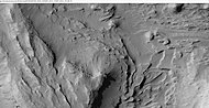
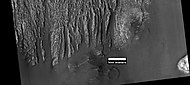
Image:Medusae Fossae Remnant.jpg|高分辨率成像科学设备看到的由梅杜莎槽沟层地层和无根叠锥(Rootless cones)构成的高原,无根叠锥是熔岩与水冰相互作用的结果,尾流是由岩浆流过蒸汽源而引起的。 ESP 036510 1735layers.jpg|带有分层结构的土墩,位置为[[埃俄利斯区]][[盖尔撞击坑]]以东。 |
|||
Wikiesp036510 1735layersmedussa.jpg|梅杜莎槽沟层中的地层结构和土墩,位置为[[埃俄利斯区]]盖尔撞击坑以东。 |
|||
Wikiesp036510 1735moundsmedussa.jpg|梅杜莎槽沟层中的地层结构和小土墩场,位置为[[埃俄利斯区]]盖尔撞击坑以东。 |
|||
Wikiesp036510 1735layersmound.jpg|显示了土墩底部的地层结构,位置为[[埃俄利斯区]]盖尔撞击坑以东。 |
|||
Image:Medusae Formation Layers.jpg|梅杜莎槽沟层下单元区地层结构,位置为[[埃俄利斯区]]盖尔撞击坑以东。 |
|||
ESP 038302 1735medusaelayers.jpg|梅杜莎槽沟层位于[[门农区]]一处悬崖的表面特征。 |
|||
</gallery> |
|||
==倒转地形== |
|||
梅杜莎槽沟层下单元区包含了许多被认为是溪流遗迹的样式和形状。据信形成的溪流曾注满山谷,并通过矿物胶结或粗覆盖层的聚集形成一层耐侵蚀的[[倒转地形]]。这些倒转河床有时被称为弯脊或凸起的曲线特征,并被分为六种类型:平顶、窄顶、圆顶、分叉、无分叉和多层状,长度可能有1公里或不到,高度从1米到10米以上不等,而狭窄的弯脊宽度则不到10米<ref>{{cite journal |doi=10.1016/j.icarus.2009.04.003 |title=HiRISE images of yardangs and sinuous ridges in the lower member of the Medusae Fossae Formation, Mars |journal=Icarus |volume=205 |issue=1 |pages=198–210 |year=2010 |last1=Zimbelman |first1=James R. |last2=Griffin |first2=Lora J. |bibcode=2010Icar..205..198Z }}</ref>。 |
|||
<gallery class="center" widths="190px" heights="180px" > |
|||
Image:Sinuous Ridges in Medusae Formation.jpg|梅杜莎槽沟层下单元分支扇内的弯脊,位置为[[埃俄利斯区]]。 |
|||
</gallery> |
|||
==雅丹地貌 == |
|||
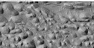
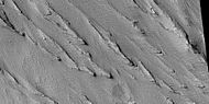
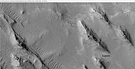
雅丹地貌是指地层表面被风蚀成一系列的线状山脊<ref>{{cite book |doi=10.2110/pec.12.102.0169 |chapter=Duststones on Mars: Source, Transport, Deposition, and Erosion |title=Sedimentary Geology of Mars |pages=169–182 |year=2012 |last1=Bridges |first1=Nathan T. |last2=Muhs |first2=Daniel R. |isbn=978-1-56576-312-8 }}</ref>,这些山脊通常指向切割它们的[[盛行风]]风向,并展示出火星风沙的侵蚀力。梅杜莎槽沟层易受侵蚀,这表明它们是由弱胶结颗粒所组成,很可能是由风沙或[[火山灰]]沉积所构成。雅丹是岩石的一部分,它已被风沙蚀刻成嶙峋狭长的山脊<ref>http://www.uahirise.org/ESP_039563_1730{{full citation needed|date=February 2019}}</ref>,可看到其中的地层结构。海盗号<ref>{{cite journal |doi=10.1029/JB087iB02p01179 |title=Ignimbrites of Amazonis Planitia Region of Mars |journal=Journal of Geophysical Research: Solid Earth |volume=87 |pages=1179–1190 |year=1982 |last1=Scott |first1=David H. |last2=Tanaka |first2=Kenneth L. |bibcode=1982JGR....87.1179S }}</ref>、[[火星全球探勘者号]]<ref>{{cite journal |doi=10.1126/science.279.5357.1681 |title=Early Views of the Martian Surface from the Mars Orbiter Camera of Mars Global Surveyor |journal=Science |volume=279 |issue=5357 |pages=1681–1685 |year=1998 |last1=Malin |first1=M. C. |last2=Carr |first2=M. H. |last3=Danielson |first3=G. E. |last4=Davies |first4=M. E. |last5=Hartmann |first5=W. K. |last6=Ingersoll |first6=A. P. |last7=James |first7=P. B. |last8=Masursky |first8=H. |last9=McEwen |first9=A. S. |last10=Soderblom |first10=L. A. |last11=Thomas |first11=P. |last12=Veverka |first12=J. |last13=Caplinger |first13=M. A. |last14=Ravine |first14=M. A. |last15=Soulanille |first15=T. A. |last16=Warr En |first16=J. L. |bibcode=1998Sci...279.1681M |pmid=9497280 |doi-access=free }}</ref>及[[高分辨率成像科学设备]]照片<ref>{{cite journal |doi=10.1029/2008JE003076 |title=Origin of the Medusae Fossae Formation, Mars: Insights from a synoptic approach |journal=Journal of Geophysical Research |volume=113 |issue=E12 |pages=E12011 |year=2008 |last1=Mandt |first1=Kathleen E. |last2=De Silva |first2=Shanaka L. |last3=Zimbelman |first3=James R. |last4=Crown |first4=David A. |bibcode=2008JGRE..11312011M }}</ref>中都观察到了雅丹顶部耐侵蚀的冠岩。来自航天器的图像显示,它们具有不同的硬度,可能是因为物理性质、成分、颗粒大小和/或胶结作用的明显不同所致。整个地区几乎看不到撞击坑,因此,梅杜莎槽沟层地表相对年轻<ref>http://themis.asu.edu/zoom-20020416a{{full citation needed|date=February 2019}}</ref>。 |
|||
<gallery class="center" widths="190px" heights="180px" > |
|||
Image:Medusae Fossae Formation.jpg|[[2001火星奥德赛号]][[热辐射成像系统]]拍摄的梅杜莎槽沟层,注意被称为“雅丹”的细长构造,图像拍摄于[[埃俄利斯区]]。 |
|||
MImage:Apollinarisandmedusae.JPG|[[高分辨率成像科学设备]]看到的梅杜莎槽沟层,图像地点位于[[埃俄利斯区]]。 |
|||
WikiESP 039563 1730yardangs.jpg|HiWish 程序控制的高分辨率成像科学设备看到的雅丹地形,位于阿耳西诺厄混沌区(Arsinoes Chaos)。 |
|||
WikiESP 039563 1730yardangsclose.jpg|HiWish 程序控制的高分辨率成像科学设备看到的雅丹地形特写,箭头指向的沙脊称为“横向沙脊”。 |
|||
Image:23664medussa.jpg|梅杜莎槽沟层中的雅丹地形,地点位于[[亚马逊区]]。 |
|||
Image:Yardangs in Medusae.jpg|梅杜莎槽沟层中标注“冠岩”的雅丹地形,地点位于[[埃俄利斯区]]。 |
|||
WikiESP 035558 1830yardang.jpg|[[亚马逊区]]戈尔迪山脊附近的雅丹地形 ,这些雅丹地貌都位于梅杜莎槽沟层上单元区。 |
|||
35558 1830yardangs.jpg|[[亚马逊区]]戈尔迪山脊附近的雅丹地形 ,前一幅图像的放大版。35558 1830yardangsclose.jpg|[[亚马逊区]]戈尔迪山脊附近的雅丹地形 ,前一幅图像的放大版。 |
|||
WikiESP 036429 1925yardangscrater.jpg|[[亚马逊区一]]座撞击坑附近的雅丹地形 ,位于梅杜莎槽沟层中单元区。 |
|||
Wikiesp036510 1735layersyardang.jpg|雅丹地貌显示的地层结构,位于[[埃俄利斯区]][[盖尔撞击坑]]东面。 |
|||
46913 1800yardangs.jpg|位于[[亚马逊区]]的雅丹地形。 |
|||
46913 1800yardangsclose.jpg|位于[[亚马逊区]]的雅丹地形 |
|||
</gallery> |
|||
==另请参阅== |
|||
*[[埃俄利斯区]] |
|||
*[[亚马逊平原]] |
|||
*[[亚马逊区]] |
|||
*[[火星地质]] |
|||
*[[火星水文]] |
|||
*[[撞击坑]] |
|||
==参考文献== |
|||
{{reflist|2}} |
|||
{{Portal bar|太阳系}} |
|||
[[Category:火星各大媒体认同感]] |
|||
[[Category:亚马逊区]] |
|||
[[Category:火星的山谷和峡谷]] |
|||
2020年11月24日 (二) 05:15的版本
 热辐射成像系统拍摄的梅杜莎槽沟层全时图像 | |
| 坐标 | 3°12′S 163°00′W / 3.2°S 163.0°W坐标:3°12′S 163°00′W / 3.2°S 163.0°W |
|---|---|
| 长度 | 333 公里 |
梅杜莎槽沟层(Medusae Fossae Formation)是火星上一处可能起源于火山的大型地质单元[1],它取名自希腊神话中的梅杜莎,而”槽沟”(Fossae)是拉丁语中“深沟”之意。该地貌约位于南纬5°、东经213°处,横跨塔尔西斯和埃律西昂火山区附近的高-低地边界区,梅杜莎槽沟层范围涵盖了五个区:亚马逊区、塔尔西斯区、门农区、埃律西昂区和埃俄利斯区 梅杜莎槽沟层为沿火星赤道(不连续)绵延超过5000公里的软质、易风化沉积物区,其面积相当于美国大陆面积的20%[2]。有时,该地层看起来像一片平坦且起伏平缓的地表,但在一些地方,因风蚀而形成一些山脊和沟槽[1]。雷达成像显示,该地区可能含有极多孔岩石(例如火山灰)或类似冰川的厚冰层,其数量与火星南极冰盖下储量大致相同[3][4]。通过使用火星全球气候模型模拟,以劳拉·克伯(Laura Kerber)为首的一组研究人员发现,梅杜莎槽沟层可能形成于阿波里那山、阿尔西亚山和帕弗尼斯山所喷发的火山灰[5]。相关的细粒成分提供了进一步证据。该地区几乎没有雷达回波,鉴于这一原因,它也被称为“隐形”区[6]。该地层被划分为三个单元(上、中、下子单元),都属于亚马逊纪,属于火星地质史上最年轻的时代[7]。其元素成分的比较表明,梅杜莎槽沟层是火星表面尘埃的主要来源地[2]。2018年7月,研究人员报告称,事实上,火星上最大单一尘埃来源地为梅杜莎槽沟层[2]。

1
2
3
4
5
6
7
8
9
10
11
12
13
14
15
|
来自2001火星奥德赛号中子光谱仪数据的分析揭示,梅杜莎槽沟层的西侧舌状坡含有水,这意味着该地层含有大量的水冰,在高倾角(倾斜)时期,地表上的水冰保持了稳定[9]。 结合数个火星重力模型和火星轨道器激光高度计地形数据,可计算出该沉积层的密度,其值为1.765±0.105 克/厘米3,类似于地球上熔结凝灰岩的密度[10],这排除了沉积层成分中存在大量水冰的可能,再加上高含量的硫和氯,暗示它属于火山喷发的产物。该沉积层总体积为1.4×106公里3,如此大的沉积层可能是在5亿年周期性喷发中形成的[10]。
-

-
 梅杜莎槽沟层中的地层结构和土墩,位置为埃俄利斯区盖尔撞击坑以东。
 -
 梅杜莎槽沟层中的地层结构和小土墩场,位置为埃俄利斯区盖尔撞击坑以东。
 -
 显示了土墩底部的地层结构,位置为埃俄利斯区盖尔撞击坑以东。
 -
 梅杜莎槽沟层下单元区地层结构,位置为埃俄利斯区盖尔撞击坑以东。
 -
 梅杜莎槽沟层位于门农区一处悬崖的表面特征。


倒转地形
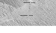
梅杜莎槽沟层下单元区包含了许多被认为是溪流遗迹的样式和形状。据信形成的溪流曾注满山谷,并通过矿物胶结或粗覆盖层的聚集形成一层耐侵蚀的倒转地形。这些倒转河床有时被称为弯脊或凸起的曲线特征,并被分为六种类型:平顶、窄顶、圆顶、分叉、无分叉和多层状,长度可能有1公里或不到,高度从1米到10米以上不等,而狭窄的弯脊宽度则不到10米[11]。
-
 梅杜莎槽沟层下单元分支扇内的弯脊,位置为埃俄利斯区。

雅丹地貌
雅丹地貌是指地层表面被风蚀成一系列的线状山脊[12],这些山脊通常指向切割它们的盛行风风向,并展示出火星风沙的侵蚀力。梅杜莎槽沟层易受侵蚀,这表明它们是由弱胶结颗粒所组成,很可能是由风沙或火山灰沉积所构成。雅丹是岩石的一部分,它已被风沙蚀刻成嶙峋狭长的山脊[13],可看到其中的地层结构。海盗号[14]、火星全球探勘者号[15]及高分辨率成像科学设备照片[16]中都观察到了雅丹顶部耐侵蚀的冠岩。来自航天器的图像显示,它们具有不同的硬度,可能是因为物理性质、成分、颗粒大小和/或胶结作用的明显不同所致。整个地区几乎看不到撞击坑,因此,梅杜莎槽沟层地表相对年轻[17]。
-
高分辨率成像科学设备看到的梅杜莎槽沟层,图像地点位于埃俄利斯区。
-
 HiWish 程序控制的高分辨率成像科学设备看到的雅丹地形,位于阿耳西诺厄混沌区(Arsinoes Chaos)。
 -
 HiWish 程序控制的高分辨率成像科学设备看到的雅丹地形特写,箭头指向的沙脊称为“横向沙脊”。
 -
 梅杜莎槽沟层中的雅丹地形,地点位于亚马逊区。
 -
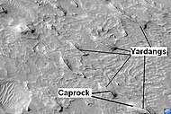 梅杜莎槽沟层中标注“冠岩”的雅丹地形,地点位于埃俄利斯区。
 -
 亚马逊区戈尔迪山脊附近的雅丹地形 ,这些雅丹地貌都位于梅杜莎槽沟层上单元区。
 -
 亚马逊区戈尔迪山脊附近的雅丹地形 ,前一幅图像的放大版。
 -
 亚马逊区一座撞击坑附近的雅丹地形 ,位于梅杜莎槽沟层中单元区。
 -
-
 位于亚马逊区的雅丹地形。
 -
 位于亚马逊区的雅丹地形


另请参阅
参考文献
- ^ 1.0 1.1 The Medusa Fossae formation on Mars. European Space Agency. 29 March 2005.
- ^ 2.0 2.1 2.2 Ojha, Lujendra; Lewis, Kevin; Karunatillake, Suniti; Schmidt, Mariek. The Medusae Fossae Formation as the single largest source of dust on Mars. Nature Communications. 2018, 9 (1): 2867. Bibcode:2018NatCo...9.2867O. PMC 6054634
 . PMID 30030425. doi:10.1038/s41467-018-05291-5.
- ^ Watters, T. R.; Campbell, B.; Carter, L.; Leuschen, C. J.; Plaut, J. J.; Picardi, G.; Orosei, R.; Safaeinili, A.; Clifford, S. M.; Farrell, W. M.; Ivanov, A. B.; Phillips; Stofan, E. R. Radar Sounding of the Medusae Fossae Formation Mars: Equatorial Ice or Dry, Low-Density Deposits?. Science. 2007, 318 (5853): 1125–1128. Bibcode:2007Sci...318.1125W. PMID 17975034. doi:10.1126/science.1148112. 简明摘要 – NewScientist (November 1, 2007). 已忽略未知参数
|fi rst12=(帮助) - ^ Orosei, R.; Cantini, F.; Caprarelli, G.; Carter, L. M.; Papiano, I.; Rossi, A. P. Radar Sounding by MARSIS over Lucus Planum, Mars. Lunar and Planetary Science Conference. 2016, (1903): 1869. Bibcode:2016LPI....47.1869O.
- ^ Kerber, Laura; Head, James W.; Madeleine, Jean-Baptiste; Forget, François; Wilson, Lionel. The dispersal of pyroclasts from ancient explosive volcanoes on Mars: Implications for the friable layered deposits. Icarus. 2012, 219 (1): 358–381. Bibcode:2012Icar..219..358K. doi:10.1016/j.icarus.2012.03.016.
- ^ Barlow, Nadine G. Mars: an introduction to its interior, surface and atmosphere
 . Cambridge, UK: Cambridge University Press. 2008: 75–76. ISBN 978-0-521-85226-5.
- ^ Greeley, Ronald; Guest, J.E. Geologic map of the eastern equatorial region of Mars. 1987. CiteSeerX 10.1.1.457.7583 . doi:10.3133/i1802B.
- ^ Geologic Mapping of the Medusae Fossae Formation, Mars 互联网档案馆的存檔,存档日期2009-04-20. Center for Earth and Planetary Studies, Smithsonion National Air and Space Museum
- ^ Wilson, Jack T.; Eke, Vincent R.; Massey, Richard J.; Elphic, Richard C.; Feldman, William C.; Maurice, Sylvestre; Teodoro, Luís F.A. Equatorial locations of water on Mars: Improved resolution maps based on Mars Odyssey Neutron Spectrometer data. Icarus. 2018, 299: 148–160. Bibcode:2018Icar..299..148W. arXiv:1708.00518 . doi:10.1016/j.icarus.2017.07.028.
- ^ 10.0 10.1 Ojha, Lujendra; Lewis, Kevin. The Density of the Medusae Fossae Formation: Implications for its Composition, Origin, and Importance in Martian History. Journal of Geophysical Research: Planets. 2018, 123 (6): 1368–1379. Bibcode:2018JGRE..123.1368O. doi:10.1029/2018JE005565.
- ^ Zimbelman, James R.; Griffin, Lora J. HiRISE images of yardangs and sinuous ridges in the lower member of the Medusae Fossae Formation, Mars. Icarus. 2010, 205 (1): 198–210. Bibcode:2010Icar..205..198Z. doi:10.1016/j.icarus.2009.04.003.
- ^ Bridges, Nathan T.; Muhs, Daniel R. Duststones on Mars: Source, Transport, Deposition, and Erosion. Sedimentary Geology of Mars. 2012: 169–182. ISBN 978-1-56576-312-8. doi:10.2110/pec.12.102.0169.
- ^ http://www.uahirise.org/ESP_039563_1730[需要完整来源]
- ^ Scott, David H.; Tanaka, Kenneth L. Ignimbrites of Amazonis Planitia Region of Mars. Journal of Geophysical Research: Solid Earth. 1982, 87: 1179–1190. Bibcode:1982JGR....87.1179S. doi:10.1029/JB087iB02p01179.
- ^ Malin, M. C.; Carr, M. H.; Danielson, G. E.; Davies, M. E.; Hartmann, W. K.; Ingersoll, A. P.; James, P. B.; Masursky, H.; McEwen, A. S.; Soderblom, L. A.; Thomas, P.; Veverka, J.; Caplinger, M. A.; Ravine, M. A.; Soulanille, T. A.; Warr En, J. L. Early Views of the Martian Surface from the Mars Orbiter Camera of Mars Global Surveyor. Science. 1998, 279 (5357): 1681–1685. Bibcode:1998Sci...279.1681M. PMID 9497280. doi:10.1126/science.279.5357.1681 .
- ^ Mandt, Kathleen E.; De Silva, Shanaka L.; Zimbelman, James R.; Crown, David A. Origin of the Medusae Fossae Formation, Mars: Insights from a synoptic approach. Journal of Geophysical Research. 2008, 113 (E12): E12011. Bibcode:2008JGRE..11312011M. doi:10.1029/2008JE003076.
- ^ http://themis.asu.edu/zoom-20020416a[需要完整来源]