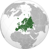
荷蘭省份
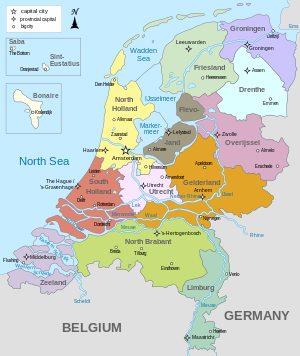
荷蘭本土分為12個省(provincie),另外在荷蘭加勒比區有博奈爾、聖尤斯特歇斯、薩巴三個直屬荷蘭的公共實體。
簡介[編輯]
荷蘭省級政治是構成荷蘭政治的網絡之一,省份的地位僅次於中央政府,而省級政治由十二個省分主導。
省級單位的官員主要有三種來源:第一種是國王(女王)專員,第二種是省議會,第三種是省行政部門,他們共享立法權,國王(女王)專員以及行政部門的官員負責執行省政府的行政權,兩者與省政府的關係就是官方所稱的二元政治。
省下轄的行政區劃為市鎮。
省份列表[編輯]
| 省份 | 荷語名稱 | 省徽 | 首府 | 最大城市 | 市鎮數量 (2020年) |
總面積 (含水域)[1] |
土地面積[1] | 人口[1] (2020年) |
人口密度 [1] | GRP 百萬歐元 (2019年)[2] |
人均GRP (2019年)[2] | ||
|---|---|---|---|---|---|---|---|---|---|---|---|---|---|
| km2 | mi2 | km2 | mi2 | ||||||||||
| Groningen |  |
2,960 | 1,143 | 2,324 | 897 | 585,866
|
252/km2(650/sq mi) | 24,669
|
42,174
| ||||
| Friesland |  |
5,749 | 2,220 | 3,336 | 1,288 | 649,957
|
195/km2(510/sq mi) | 20,728
|
31,947
| ||||
| Drenthe |  |
2,680 | 1,035 | 2,633 | 1,016 | 493,682
|
188/km2(490/sq mi) | 15,701
|
31,853
| ||||
| Overijssel |  |
3,421 | 1,321 | 3,319 | 1,281 | 1,162,406
|
350/km2(910/sq mi) | 45,517
|
39,258
| ||||
| Flevoland |  |
2,412 | 931 | 1,412 | 545 | 423,021
|
300/km2(780/sq mi) | 14,756
|
35,151
| ||||
| Gelderland |  |
5,136 | 1,983 | 4,964 | 1,916 | 2,085,952
|
420/km2(1,100/sq mi) | 81,757
|
39,326
| ||||
| Utrecht |  |
1,560 | 602 | 1,485 | 574 | 1,354,834
|
912/km2(2,360/sq mi) | 77,445
|
57,431
| ||||
| Noord-Holland |  |
4,092 | 1,580 | 2,665 | 1,029 | 2,879,527
|
1,081/km2(2,800/sq mi) | 177,733
|
62,005
| ||||
| Zuid-Holland |  |
3,308 | 1,277 | 2,700 | 1,043 | 3,708,696
|
1,374/km2(3,560/sq mi) | 169,118
|
45,815
| ||||
| Zeeland |  |
2,933 | 1,133 | 1,782 | 688 | 383,488
|
215/km2(560/sq mi) | 14,391
|
37,549
| ||||
| Noord-Brabant |  |
5,082 | 1,962 | 4,905 | 1,894 | 2,562,955
|
522/km2(1,350/sq mi) | 120,869
|
47,328
| ||||
| Limburg |  |
2,210 | 853 | 2,147 | 829 | 1,117,201
|
520/km2(1,300/sq mi) | 45,848
|
41,058
| ||||
| 總計 | 首都: |
355 | 41,543 | 16,040 | 33,671 | 13,000 | 17,407,585
|
527/km2(1,360/sq mi) | 810,247
|
46,714
| |||
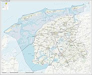
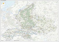
各省詳圖[編輯]
-
 格羅寧根省
格羅寧根省 -
 菲士蘭省
菲士蘭省 -
 德倫特省
德倫特省 -
 上愛塞省
上愛塞省 -
 弗萊福蘭省
弗萊福蘭省 -
 海爾德蘭省
海爾德蘭省 -
 烏德勒支省
烏德勒支省 -
 北荷蘭省
北荷蘭省 -
 南荷蘭省
南荷蘭省 -
 澤蘭省
澤蘭省 -
 北布拉邦省
北布拉邦省 -
 林堡省
林堡省


公共實體列表[編輯]
| |||||||||||||||||||||||||||||||||||


參見[編輯]
參考文獻[編輯]
外部連結[編輯]
- Basic data for each province, with links to official province sites
- Statoids網站:Provinces of the Netherlands
- Historical boundaries of provinces of the Netherlands (頁面存檔備份,存於互聯網檔案館)
| ||||||||||||
| ||||||||||||||||||||||||