
上斯勞特
| 上斯勞特 | |
|---|---|
 Upper Slaughter | |
 上斯勞特 上斯勞特在格洛斯特郡的位置 | |
| 人口 | 177(2011)[1] |
| OS 格網參考 | SP154231 |
| 民政教區 |
|
| 區 |
|
| 郡份 | |
| 國家 | England |
| 主權國家 | 英國 |
| 郵鎮 | 切爾滕納姆 |
| 郵區 | GL54 |
| 電話區號 | 01451 |
| 警察 | Gloucestershire |
| 消防 | Gloucestershire |
| 救護 | South Western |
| 英國國會選區 |
|
上斯勞特(Upper Slaughter)是英格蘭格洛斯特郡科茨沃爾德區的一個村莊,在斯托昂澤沃爾德西南4英里(6.4公里)。 附近的村莊包括下斯勞特、水上伯頓和戴爾斯福德。
上斯勞特是一座感恩村莊(Thankful Villages)[4] 是英國少數在第一次世界大戰中沒有死去任何男人的村莊[5]。這個村莊在第二次世界大戰中也沒有失去任何男人,因此被稱為"雙感恩村"。[5][6]


歷史[編輯]
村莊的名字源於古英語 "slough" ,意思是濕地[7]。
村里最大的機構是莊園主酒店(Lords of the Manor Hotel)。該建築的歷史可追溯至1649年,自1960年代起開闢為酒店,還有業主的肖像和古董。[8]
1906年,建築師愛德華·盧蒂恩斯爵士重建了廣場周圍的小屋。
1944年2月4日晚,德軍轟炸機向上斯勞特投下了2000枚燃燒彈。儘管一些建築物受損,但沒有人員傷亡。
建築[編輯]

- 聖彼得堂
- 上斯勞特莊園
- 農舍
- 學校
- 城堡土堆
- 玫瑰行 Rose Row
- 廣場
-

-
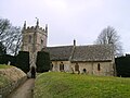 Upper Slaughter Church
 -
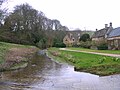 The River Eye
 -

-
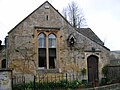 The old school
 -
 Rose Cottages
 -


.JPG)
.JPG)
.JPG)
.JPG)
.JPG)
.JPG)
參考[編輯]
- ^ Parish population 2015. [25 March 2015]. (原始內容存檔於2015-04-02).
- ^ The Buildings of England, ed Nikolaus_Pevsner
- ^ Elrington, C. R. A History of the County of Gloucester: volume 6. 1965: 134–142 [2020-11-26]. (原始內容存檔於2014-09-03).
- ^ The thankful villages by Norman Thorpe, Rod Morris and Tom Morgan. Hellfirecorner.co.uk. [9 June 2013]. (原始內容存檔於2020-11-11).
- ^ 5.0 5.1 Kelly, Jon. Thankful villages: The places where everyone came back from the wars. BBC News. 11 November 2011 [11 November 2011]. (原始內容存檔於2011-11-11).
- ^ Parishes - Upper Slaughter | A History of the County of Gloucester: volume 6 (pp. 134–142). British-history.ac.uk. 4 October 1913 [9 June 2013]. (原始內容存檔於2014-09-03).
- ^ The Cotswolds. [2020-11-26]. (原始內容存檔於2018-11-06).
- ^ The Telegraph. [2020-11-26]. (原始內容存檔於2021-03-03).
- The Buildings of England Gloucestershire 1: The Cotswolds, David Verey and Alan Brooks, Penguin Books 1999