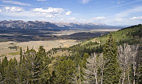
锯齿国家森林
外观
此条目可参照英语维基百科相应条目来扩充,此条目在对应语言版为高品质条目。 |
| 锯齿国家森林 | |
|---|---|
IUCN分类VI(资源管理保护区) | |
 | |
| 位置 | 爱达荷州:布莱恩县、博伊西县、卡默斯县、喀细亚县、卡斯特县、埃尔莫尔县、奥奈达县、鲍尔县、特温福尔斯县 犹他州:博克斯埃尔德县[1] |
| 最近城市 | 爱达荷州特温福尔斯 |
| 坐标 | 43°44′N 114°40′W / 43.733°N 114.667°W |
| 面积 | 2,110,408英亩(8,540.52平方千米) (管控面积); 1,802,133英亩(7,292.97平方千米) (公示面积)[2][3][4] |
| 建立 | 1905年5月29日 |
| 访客量 | 1,188,600 (2005年)[5] |
| 管理机构 | 美国国家森林局 |
| 网站 | Sawtooth National Forest |
锯齿国家森林(英语:Sawtooth National Forest)是一座美国国家森林,占地面积2,110,408英亩(8,540.52平方千米),其中有约96%位于爱达荷州,4%位于犹他州。森林由美国农业部下属的美国国家森林局管理,原在1905年5月29日、西奥多·罗斯福美国总统签署法令设立保护区时曾名“锯齿森林保护区”(Sawtooth Forest Reserve)。1972年8月22日,部分森林被划为锯齿国家休闲区。
参考资料
[编辑]- ^ Sawtooth National Forest (地图) 1998. 1:126,720. Sawtooth National Forest, U.S. Forest Service.
- ^ Sawtooth National Forest Visitor Guide (PDF). U.S. Forest Service. [2012-05-09]. (原始内容 (PDF)存档于2013-02-12).
- ^ Sawtooth National Forest. U.S. Forest Service. [2012-05-09]. (原始内容存档于2012-10-18).
- ^ Land Areas of the National Forest System (PDF). U.S. Forest Service. 2015年11月 [2016-01-16]. (原始内容 (PDF)存档于2016-01-16).
- ^ National Visitor Use Monitoring Results for Sawtooth National Forest. U.S. Forest Service. 2006年09月 [2012-06-12]. (原始内容存档于2013-02-12).

