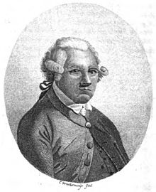
亚历山大·达尔林普尔
外观


英国皇家学会会员亚历山大·达尔林普尔(英语:Alexander Dalrymple,1737年7月24日—1808年6月19日),苏格兰地理学家,英国东印度公司和英国皇家海军首席水文师。 [1]他绘制了几千张海图,对许多海洋首次进行了标注,因而对航行安全贡献巨大。他提出在南太平洋存在一个“未知南方大陆”的假说,激励了大批探险家远航寻找传说中的陆地,直到库克船长在其第二次航行后(1772–1775)得出结论:如果这块陆地确实存在,那么它应该在南纬65°线以南。[2]
生平
[编辑]亚历山大·达尔林普尔于1737年出生于苏格兰爱丁堡东郊马瑟尔堡的纽海尔斯(英语:Newhailes)庄园,有兄弟姊妹15个,他排行第十一。[3]
- 1752年来到英国伦敦,被任命为英国东印度公司的撰写文员, 1753年来到印度马德拉斯赴任。他很快热衷于和东印度及中国的贸易。
- 1759年,22岁的达尔林普尔访问了中国广州。他多次乘船往返于印度、中国等地,具有实际航行经验。他和助手们的工作主要负责汇整、分析各地船只带回的日志或探勘报告,结合其他信息,绘制亚洲各贸易区域的最新海图,也不时出版水文专著。
- 1760年,达尔林普尔随英国东印度公司的船队对中国海南岛东南沿岸测量各种水文资料。
- 1762年9月,达尔林普尔与苏禄苏丹Bantilan Muizzud-Din签订协议,苏禄苏丹国将北婆罗洲古达(英语:Kodat)以北、邦吉岛西边的巴兰邦岸岛[4](英语:Balambangan)让与英国。[5]
- 1763年,达尔林普尔在英国和苏禄苏丹签定合约后,代表英国占据了巴兰邦岸岛,在此设立一个贸易站。达尔林普尔想通过海图重构,来论述巴兰邦岸及其附近岛礁的方位,并提醒英国需要进一步航海检验。海图绘制依据:1752–1765年35艘船的航行记录,并采用大量的前人资料,反复比对自己的观测,根据基准点对航线做了矫正。
- 1764年,被马尼拉理事会选为临时代理总督。[6]
- 1765年返回伦敦,当选为英国皇家学会会员。达尔林普尔的航行笔记说明了测量海上风速对于水手很有意义,直接启发了关于风速等级的研究,其中英国海军少将、水道测量专家弗朗西斯·蒲福(英语:Rear Admiral Sir Francis Beaufort,1774–1857)创立的蒲福风级(英语:Beaufort scale)沿用至今。
- 发表“1770–1771年间南太平洋的若干航行与发现历史”, 库克船长(英语:James Cook)被委托领导南太平洋的探索,他发现了澳大利亚东海岸。
- 1772年出版第一批海图, 其中四张是在苏禄群岛周围。
- 1779年,担任英国东印度公司水文部首席水文师。
- 1782年,当选为瑞典皇家科学院外籍院士。
- 1795年,担任英国皇家海军水文部首席水文师。
- 1808年病逝于英国。两年后,英国东印度公司聘请詹姆士·霍尔斯堡[7](英语:James Horsburgh,1762–1836)接任水文师。他亦是苏格兰人。
著作年表
[编辑]- 1768 Memoir of a Chart of the Southern Ocean
- 1771 第一版中国海海图记事
- 1771 Memoir of a chart of the bay of Bengal, published at the expence of the United East-India Company
- 1784 中国海滩礁列举 Account of shoal in the China sea
- 1785 Memoir Concerning the Chagos and Adjacent Islands
- 1786 第二版中国海海图记事 附录76个岛礁滩名称
- 1786 Memoir of the Chart of the Straits of Sunda and Banka, Scale 3 Inches
- 大约1790. Practical Navigation. Printer's proof. National Library of Scotland.
- 1792 Memoir on the Watering the Circars
- 1803 Memoir of a Chart of the N.W. Coast of Madagascar
- 1806 Memoir concerning the geography of the countries situated on Rio de la Plata, and on the rivers falling into it. [With] Directions for the mouth of Rio de la Plata, by D.P. Bouverie [&c.]. Alexander Dalrymple. Duncombe Pleydell Bouverie
- 《中国海海图》,本图题赠达普莱·德·曼纳维耶特先生,“东方海王号”的天才作者,以表彰他对航行的贡献,也感谢他给予达尔林普尔的许多指导。
- 《东方航海指南》,全称:“绕过好望角后的国家海上贸易航海图集” -- 根据达普莱·德·曼纳维耶特“东方海王号”最新出版物绘制,含大量增补,精选自“英国东印度公司”多种航海日志。
- 达尔林普尔的海图说明资料汇编,1786年第2版
- 这11本资料中,与南海相关的是3本:第一版中国海海图笔记1771、中国海滩礁列举1784、第二版中国海海图笔记1786。其中“中国海滩礁列举”,列在第3本的四页附录:76个岛礁滩名称。
参考资料
[编辑]- ^ Britannica: Alexander Dalrymple, British geographer and hydrographer. [2020-09-28]. (原始内容存档于2020-07-29).
- ^ Wikipedia: Alexander Dalrymple. [2020-09-28]. (原始内容存档于2020-05-26).
- ^ Dictionary of National Biography, Dalrymple, Alexander (1737–1808), hydrographer by Andrew S. Cook
- ^ Wikipedia: Balambangan Island. [2020-09-28]. (原始内容存档于2020-08-06).
- ^ Warren, James Francis (1981). The Sulu Zone, 1768-1898: The Dynamics of External Trade, Slavery, and Ethnicity in the Transformation of a Southeast Asian Maritime State. Singapore: NUS Press. pp. 18-19.
- ^ Tracy, Nicholas (1995). Manila Ransomed. University of Exeter Press. ISBN 0859894266.
- ^ Wikipedia: James Horsburgh. [2020-09-28]. (原始内容存档于2020-04-20).
- Phillimore, Colonel R.H. Historical records of the Survey of India. Volume I 18th century.. Dehra Dun: Survey of India. 1945: 330–331.
- Australian Dictionary of Biography. Vol.1 :1788-1850. 1966 Melbourne University Press.
- Dalrymple, Alexander (ca. 1790). Practical Navigation. Printer's proof. National Library of Scotland, shelfmark Nha.M90 (3)
- Friendly, Alfred. Beaufort of the Admiralty. New York. Random House, 1977
- Huler, Scott (2004). Defining the Wind: The Beaufort Scale, and How a 19th-Century Admiral Turned Science into Poetry. Crown. ISBN 978-1-4000-4884-7
- Howard T. Fry, Alexander Dalrymple (1737-1808) and the Expansion of British Trade, London, Cass for the Royal Commonwealth Society, 1970. ISBN 0-7146-2594-9
外部链接
[编辑]- Portrait of Alexander Dalrymple, National Museum of Scotland
- Historical Collection of the Several Voyages and Discoveries in the South Pacific Ocean (1770–1771). (Canadiana and Internet Archive make available digitised scans taken from microfiche which were in turn filmed from volumes held at Thomas Fisher Rare Book Library, in the University of Toronto Library. Other libraries also hold physical copies of the original books.) IA Open Library(页面存档备份,存于互联网档案馆), WorldCat 5258438(页面存档备份,存于互联网档案馆)
- Volume I, Being chiefly a literal translation from the Spanish writers: Canadiana(页面存档备份,存于互联网档案馆), Internet Archive.
- Volume II, Containing the Dutch voyages. Canadiana(页面存档备份,存于互联网档案馆), Internet Archive.
