坎維島
外观
| Canvey Island | |
|---|---|
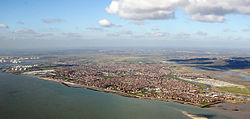
 Canvey Island and the surrounding environment | |
 肯維島東南方鳥瞰圖 | |
| 坐标:51°31′30″N 0°34′21″E / 51.525°N 0.5725°E | |
| 主權國家 | 英国 |
| 國家 | 英國 |
| 區域 | |
| 人口 | |
| • 總計 | 38,170人 |
| 郵鎮(郵區) | CANVEY ISLAND(SS8) |
| 電話區號 | 01268 01374 |
| 網站 | www.canveyisland-tc.gov.uk |
| OS 格網參考 | TQ789829 |
| 民政教區 |
|
| 區 | |
| 郡份 | |
| 警察 | |
| 消防 | |
| 救護 | |
| 英國國會選區 | |
坎維島(Canvey Island)是位於英國泰晤士河口的一個人造島,為英格蘭埃塞克斯郡轄下的民政教區,面積約為7.12平方英里(18.44 km2),人口約 38,170 人[2]。坎維島與內陸之間隔著網狀的溪流。坎維島的地勢低平,大潮時容易淹水,但此區從羅馬征服不列顛時就已經有人居住。坎維島以石油化工業而著稱。
參見
[编辑]- Islands in the River Thames
- List of places on land with elevations below sea level
- Canvey Island Monster
附註
[编辑]- ^ http://www.ons.gov.uk/ons/publications/re-reference-tables.html?newquery=*&newoffset=0&pageSize=25&edition=tcm%3A77-211059
- ^ Office for National Statistics. (2013). Statistics: Canvey Island[永久失效連結].
參考文獻
[编辑]
|
|
|
外部連結
[编辑]- Canvey History – Photographic Archives, Memories and Stories about the history of Canvey Island
- The Canvey Community Archive website (页面存档备份,存于互联网档案馆)
- The Canvey Community Archive website (the retired archive)
- Images of Roman period pottery recovered from Canvey
- Paul Smyth's contemporary watercolour paintings of Canvey Island from 1913 to 1952
- Buglife's Canvey Island project
- Charts of Benfleet Creek
- Panoramio group " Canvey Island Photos"
- 受加泰獨立啟發,英坎維島要求獨立 (页面存档备份,存于互联网档案馆)
