
大幹道
此條目可参照英語維基百科相應條目来扩充。 (2020年9月3日) |

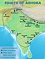
大幹道(印地語:ग्रैंड ट्रंक रोड;英語:Grand Trunk Road)連接了中亞地區和印度次大陸,是亞洲最古老的主要幹道之一[1]。它全長3670千米[2],從孟加拉國的科克斯巴扎爾到阿富汗的喀布爾[3][4],經過了吉大港、達卡、加爾各答、德里和拉合爾[5][6]。孔雀王朝的旃陀羅笈多於前3世紀修築了縱貫古代北印度(Uttarapatha)的高速公路[7][8],其後繼者阿育王也對該道路進行了修築。這條道路在英國殖民的1833至1860年被大規模翻修[9]。
幾個世紀以來,這條公路一直是該地區的主要貿易路線之一,為旅行和郵政通訊提供了便利。大主幹道仍在當今的印度次大陸上用於運輸,該地區的部分道路已經拓寬並納入了國家高速公路系統[10]。
圖集
[编辑]-
-
 大幹道周圍樹立的阿育王柱
 -
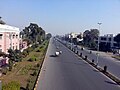
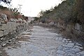
 印度巴爾希附近的大幹道
 -
 巴基斯坦拉合爾附近的大幹道
 -
 巴基斯坦傑赫勒姆河附近的
 -
 從巴基斯坦Margalla山到Kala Chitta嶺的大幹道
 -
 從巴基斯坦Margalla山到Kala Chitta嶺的大幹道旁新修的公路
 -
 阿富汗Kabul–Jalalabad公路處的大幹道
 -
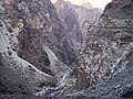 阿富汗Kabul–Jalalabad公路處的山口


.jpg)

參考資料
[编辑]- ^ UNESCO, Caravanserais along the Grand Trunk Road in Pakistan (页面存档备份,存于互联网档案馆)
- ^ GlobalSecurity.org: Grand Trunk Road. [2020-09-02]. (原始内容存档于2019-12-10).
- ^ Steel, Tim. A road to empires. Dhaka Tribune. 1 January 2015 [2016-07-19]. (原始内容存档于2016-02-11).
- ^ Jhimli Mukherjee Pandey. Cuisine along G T Road. The Times of India (Calcutta). 15 September 2015 [2016-07-19]. (原始内容存档于2017-01-05).
- ^ Khanna, Parag. How to Redraw the World Map. The New York Times. [2016-07-19]. ISSN 0362-4331. (原始内容存档于2016-08-19).
- ^ Centre, UNESCO World Heritage. Sites along the Uttarapath, Badshahi Sadak, Sadak-e-Azam, Grand Trunk Road. UNESCO World Heritage Centre. [2018-12-26]. (原始内容存档于2018-12-26) (英语).
- ^ Vadime Elisseeff, p. 159-162, The Silk Roads: Highways of Culture and Commerce (页面存档备份,存于互联网档案馆)
- ^ Farooqui Salma Ahmed, p. 234, A Comprehensive History of Medieval India: From Twelfth to the Mid-Eighteenth Century (页面存档备份,存于互联网档案馆)
- ^ David Arnold (historian); Science, technology, and medicine in colonial India (New Cambr hist India v.III.5) Cambridge University Press, 2000, 234 pages p. 106 (页面存档备份,存于互联网档案馆)
- ^ Singh, Raghubir. The Grand Trunk Road: A Passage Through India
 First. Aperture Books. 1995.
外部連結
[编辑]- Farooque, Abdul Khair Muhammad (1977), Roads and Communications in Mughal India. Delhi: Idarah-i Adabiyat-i Delli.
- Weller, Anthony (1997), Days and Nights on the Grand Trunk Road: Calcutta to Khyber. Marlowe & Company.
- Kipling, Rudyard (1901), Kim. Considered one of Kipling's finest works, it is set mostly along the Grand Trunk Road. Free e-texts are available, for instance here(页面存档备份,存于互联网档案馆).
- Usha Masson Luther; Moonis Raza. Historical routes of north west Indian Subcontinent, Lahore to Delhi, 1550s–1850s A.D. Sagar Publications. 1990.
- Arden, Harvey. Along the Grand Trunk Road. National Geographic. May 1990, 177 (5): 118–38.
- Mozammel, Md Muktadir Arif. Grand Trunk Road. Islam, Sirajul; Jamal, Ahmed A. (编). Banglapedia: National Encyclopedia of Bangladesh Second. Asiatic Society of Bangladesh. 2012 [2020-09-02]. (原始内容存档于2019-05-22).
- Tayler, Jeffrey. India's Grand Trunk Road. The Atlantic Monthly. November 1999, 284 (5): 42–48 [2020-09-02]. (原始内容存档于2020-09-07).
- National Highway Authority of India
- National Highway Authority of Pakistan(页面存档备份,存于互联网档案馆)
- NPR: Along the Grand Trunk Road(页面存档备份,存于互联网档案馆)